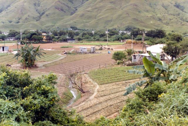
Greetings. Andrew, allow me to try. Corrections welcome. Following your hint between Kam Tin and Sek Kong, the nearby hills would be to the north.
On the right, the hill slopes gently downward and its spur feature is aiming at, for reference, a bit to the left of the banana tree. On the left, there are two near-parallel spur features, with a stream between them and another stream to the right (east). These two streams meet at a location further downstream but their junction is not visible due to a spur line that extends from the right. If my estimate is correct, the united stream flows into Tai Kong Po shown on the 1952 contour map. These spur features appear to match the contours on the 1952 map.
This would place you and your camera high on the main road about midpoint between Kam Tim and Sek Kung Camp and looking to the NNE. A very few of these fields are still operational in looking at current Google aerial photos.
I think that you have probably found the location. I have just re-read our holiday diary from August 1981 and see that we had taken a bus from Kowloon to Yuen Long, where unfortunately I didn't take any photographs, and then caught another bus to Kam Tin from a temporary bus terminus on some waste land immediatley on the East of Yuen Long, where I think that the road crossed a river. After visiting the walled village we walked in fierce heat (Judy wrote that her hand was so slippery she could hardly hold her umbrella up to ward off the sun) through the town (again no photographs) and all the way along the main road to and past the Sek Kong camp, where our diary notes that the Ghurkhas were stationed. The diary also reads that the visit to the New Territories was specifically to take photographs of the fields and rural scenes, so in the days of the limitations of film I might have decided not to bother with buildings. According to the diary, somewhere possibly not far beyond the Sek Kong camp, we decided that it was too hot for comfort and decided to catch a bus back to Kowloon. The diary notes that the bus took us over a mountain pass, the only likely one would have been on the Twisk Route. A group of boy and girl scouts each carrying heavy rucksacks boarded the bus on the pass, and that area would have been a very likely place for them to have been hiking on. Any thoughts, anyone? Best wishes, Andrew
Hi Andrew, since you walked from Kam Tin to and past the Sek Kong camp, I think you took this photo while standing at or very close to the junction of the main road and the NW-SE Sek Kong road the latter the only camp road shown on the 1952 map.
At this spot, the 1952 shows a creek that would be the same as in the photo. The two walk paths seem to match. To the north, the two pararrel spur contours aim directly southward, as are in the photo. Regards, Peter
I sent the previous comment unintentionally, and then changed it before seeing your comment! I think that the photograph was taken somewhere between the Sek Kong camp and the junction just above the 'San' of San Lung Wai on the 1952 map. I now see on the map that a bus travelling from the West would take the southern brown road at that junction and then head round and south to go over theTwisk road. Andrew
Thank you Andrew for nailing down the correct location. I was mistaken when I put the two water channels on equal footing. The one on the photo was too small to show up on the 1952 map. Those spur lines are still looking at you standing at the correct location. Regards, Peter
Comments
Fields between Kam Tin and Sek Kong
Greetings. Andrew, allow me to try. Corrections welcome. Following your hint between Kam Tin and Sek Kong, the nearby hills would be to the north.
On the right, the hill slopes gently downward and its spur feature is aiming at, for reference, a bit to the left of the banana tree. On the left, there are two near-parallel spur features, with a stream between them and another stream to the right (east). These two streams meet at a location further downstream but their junction is not visible due to a spur line that extends from the right. If my estimate is correct, the united stream flows into Tai Kong Po shown on the 1952 contour map. These spur features appear to match the contours on the 1952 map.
This would place you and your camera high on the main road about midpoint between Kam Tim and Sek Kung Camp and looking to the NNE. A very few of these fields are still operational in looking at current Google aerial photos.
https://www.google.ca/maps/place/Kam+Tin+Rd,+Kam+Tin,+Hong+Kong/@22.454…;
Regards, Peter
Hi Peter,
Thanks Peter,
I think that you have probably found the location. I have just re-read our holiday diary from August 1981 and see that we had taken a bus from Kowloon to Yuen Long, where unfortunately I didn't take any photographs, and then caught another bus to Kam Tin from a temporary bus terminus on some waste land immediatley on the East of Yuen Long, where I think that the road crossed a river. After visiting the walled village we walked in fierce heat (Judy wrote that her hand was so slippery she could hardly hold her umbrella up to ward off the sun) through the town (again no photographs) and all the way along the main road to and past the Sek Kong camp, where our diary notes that the Ghurkhas were stationed. The diary also reads that the visit to the New Territories was specifically to take photographs of the fields and rural scenes, so in the days of the limitations of film I might have decided not to bother with buildings. According to the diary, somewhere possibly not far beyond the Sek Kong camp, we decided that it was too hot for comfort and decided to catch a bus back to Kowloon. The diary notes that the bus took us over a mountain pass, the only likely one would have been on the Twisk Route. A group of boy and girl scouts each carrying heavy rucksacks boarded the bus on the pass, and that area would have been a very likely place for them to have been hiking on. Any thoughts, anyone? Best wishes, Andrew
Fields between Kam Tin and Sek Kong
Hi Andrew, since you walked from Kam Tin to and past the Sek Kong camp, I think you took this photo while standing at or very close to the junction of the main road and the NW-SE Sek Kong road the latter the only camp road shown on the 1952 map.
At this spot, the 1952 shows a creek that would be the same as in the photo. The two walk paths seem to match. To the north, the two pararrel spur contours aim directly southward, as are in the photo. Regards, Peter
Hi Peter,
Hi Peter,
I sent the previous comment unintentionally, and then changed it before seeing your comment! I think that the photograph was taken somewhere between the Sek Kong camp and the junction just above the 'San' of San Lung Wai on the 1952 map. I now see on the map that a bus travelling from the West would take the southern brown road at that junction and then head round and south to go over theTwisk road. Andrew
Fields between Kam Tin and Sek Kong
Thank you Andrew for nailing down the correct location. I was mistaken when I put the two water channels on equal footing. The one on the photo was too small to show up on the 1952 map. Those spur lines are still looking at you standing at the correct location. Regards, Peter