
Uphill from the Hatton Road Sitting Out Area park, there are two "tolerated structures" on Government owned property - surrounded by a fence - that are going to waste.
(you have to go to Centamap.com - it is not shown on Google Maps.
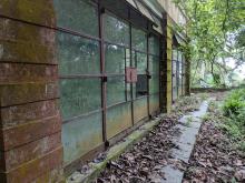
One building is a one bedroom / one bathroom bungalow c.1970. The other has a very large living and two small bedrooms and an outside kitchen also c.1970. Between them is a large, flat garden. Each building has big glass windows that face onto the garden.
It is zoned agricultural, but the two buildings should really be restored and put to use as nature displays for Lung Fu Shan Country Park.
TS, or "tolerated structures", is usually code for squatter hut, but in this case, the buildings were clearly a nice home.
About 10 years ago it appeared to be run as an aviary or some such as you could always hear birds from behind the wall.
I found reference to a man, 麥正, a "well-known cartoonist" who emigrated to Canada in 1992, who created 正園花園 (Ching Yuen Garden) in 1972.
But why has Ching Yuen Garden been allowed to go to seed (pun intended).
Photos that show this Place
Comments
Re: Ching Yuen
Hi there,
I remember there is a big notice board written in Chinese urging to setup some sort of a fund to restore the site and open to the public for quite a while. I'll see if I could take a few snaps the next time I walk by.
Best Regards,
T
Master Mak Ching wrote by
re: Master Mak
Interesting. I think the '炮台山' he refers to is Pinewood Battery, which is just a bit further up the hill from Ching Yuen.
Cing Yuen Gardens
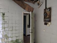
Hello, does anybody know who owns/ manages Ching Yuen Gardens now? I live nearby and am involved in a public art project, which is attempting to open such spaces to the public. Lately, it appears that the building has been left open to the elements and the internal walls vandalised, which is truly a crying shame! There is a sign hanging over the gate which reads "The Love Garden", but it could certainly use some love and attention now by the looks of it... Any info gratefully received!
Contact the Lands
Contact the Lands Department: http://www.landsd.gov.hk/en/about/enquiries.htm. Or go in person:
2835 1711
Cing Yuen
Hi Artinheaven, I'm working on a university project about this part of HK which involves looking at properties in the area that are unoccupied. We'd be really interested in talking to your art group. Could you let me know how to get in touch with you? If you like you could send me an email to solum@hku.hk. Best regards, Aleksander
Ching Yuen Garden
Doing some work for a guided tour of the Pinewood Battery/Lung Fu Shan area, I've stumbled over the history of the Ching Yuen Garden. Mak Ching's belief that it was a rear area for the WW2 battery seems to be correct. The aerial photographic evidence shows nothing there in 1924. That was shortly after, interestingly, Pinewood Battery ceased being a military location, was resumed by the government and handed over to the pretty new Hong Kong Scouts as a sort of Gilwell Camp location. Not sure how long that lasted, but not beyond c.1930 (have yet to find the smoking gun for military resumption).
When it was resumed by the military, however, and Pinewood Battery rebuilt as an AA battery, what was built in addition was the platform on which Ching Yuen Garden stands, along with a building (probably the smaller bungalow (so bungalow maybe 1930s)). A 1945 aerial photo shows a clear, military layout with a single building and what looks like a set of rectangular areas - possible store dumps or tented accommodation sites.
That location stays looking like that through subsequent aerial photos through to 1952 (when it first appears on a topographical map). Sometime between 1952 and 1960 it was taken over by the Malaria Bureau (they meant Anti-Malaria!) and used, as a 1:1000 map indicates, as "quarters and store" pretty much retaining the same layout as it had in HKSRA days, though by 1960 with the bungalow and six, equal sized rectangular areas, probably the stores. It stays as the Malaria Bureau's local Mid-Levels base through until about 1970-72 - the layout in aerial photos in 1963 and 1968 still looks pretty organized, but in 1972 it looks abandoned. On 1975 maps it begins to change, but in aerial photos it doesn't seem to get its second building until the later 1980s.
As one of the folk I work with commented, with it as a manifest part of Pinewood Battery (a listed heritage site); with two fairly distinguished post-war HK artists having lived there; with it having been something of an artistic rendezvous point for HK artists in the 70s and 80s; and with it featuring as 山之半 居 (the house half way up the mountain) in many of the very distinguished Huang Yong Yu's ( 黄永玉 ) paintings (today very valuable collectors' pieces - HK$1.5 million being a recent price at Christie's for those (like the HK Government) for whom that's the only sort of metric that matters), one would have thought that by now an intelligent government that actually knew something of the history of the place that it governs, might have rescued the place from rack and ruin and turned it into a self-supporting artists' venue - a sort of Mid-Levels Cattle Depot. Fat chance.
StephenD
re: Ching Yuen Garden
Thanks Stephen, the site is older than I expected.
There's a brief mention of the Malaria Bureau moving here on page 188 of Plague, SARS and the Story of Medicine in Hong Kong:
Ching Yuen Garden
Thanks David - good to know the dates of relocation and departure.
Best,
StephenD