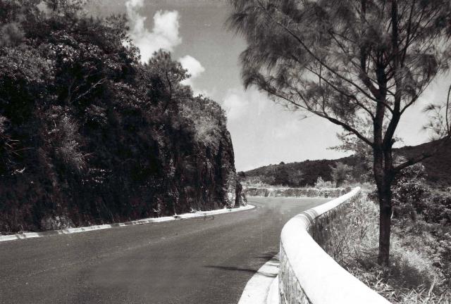
Probably the New Territories or possibly on the Island.
Following Moddseys's and Peter's suggestions, and my subsequent comments, I now believe that this photograph was taken on the Tai Tam Road to the North or North East of the reservoir dam. It's very difficult to pin-point the exact spot because the two very distinctive sharp double bends, that look likely, do not match what one can see on the modern Google Earth Street View. However, I have placed the pin on the map in possibly the right place, not very far from the junction of the Shek O and Tai Tam roads at the Tai Tam Gap, which is probably just out of sight behind the edge of the cliff face on Malcolm's photograph. It is thought that the gently rising slope in the background on the photograph is the lower North end of Mt Collinson. The Shek O road would have been running horizontally more or less in line with the far wall. Thanks for the help of several contributors. I hope this is correct! (Andrew S)
Comments
Tai Tam Road
I think this photo is also related to the Stanley walk that Malcolm did. Looks like near Red Hill before the road was widened. Just my guess. Cheers!
Hi Moddsey,
Hi Moddsey,
Checking on Malcolm's original file of images, I see that this one was numerically right next to the two others that he took near Tai Tam Tuk. It was the last of the three, with the one closest to the Tai Tam Tuk reservoir being the first, suggesting that the numericdal order had simply been reversed by Malcolm when he 'catalogued' them. The curve of the road rang a bell for me and I suggest that this photograph was taken on his way to Tai Tam Tuk at either of the very sharp double bends in the Tai Tam Road on the south or south east side of Boa Vista - see the 1952 map. I certainly passed that way on a few occasions in 1958. I also think that, having walked all the way from Little Sai Wan, the reservoir was his objective, as it was mine and, knowing that he'd have to walk all the way back to camp, he'd have been unlikely to press on much further into 'unknown terrtory'. Remember that we did not have any maps. Best wishes Andrew
Re: Bend
Thanks. This was the bend that may show the hillside on the right before the road works improvement.
Hi Moddsey. Do you mean the
Hi Moddsey. Do you mean the bend where the Tytam AASL shelter is pinned on the 1952 map, or the more gradual one a bit further South? Regards Andrew
Pak Pat Shan Road
It is close to the junction of Pak Pat Shan Road and Tai Tam Road but looking north. No worries if it is not. Cheers!
An interesting dilemma. I
An interesting dilemma. I still think that the place where Malcolm stood is more likely to have been at one of the sharpish bends shown on the 1952 map to the North East of the dam. To me it seems a logical place on his walk. Unfortunately, on Google Earth Street View, the vegetation now blocks good views of all the hills which would help a positive identification. The ones showing in the Pak Pat Han street views do not look high enough to be Mt Parker or Mt Butler, etc.. Does anyone else have any thoughts? Andrew
Tai Tam Road Double Curve
Greetings. " ... either of the very sharp double bends in the Tai Tam Road on the south or south east side of Boa Vista..."
It appears these double bends are still there, and the spot remains two-lane wide. On Google map, place your view on the south bend, fine tone it using the small (lower left) map window to mid-point between the two road names, then look north. The 2009 view shows the ridgeline straight ahead which might help confirm or reject this alternative. The tree in this photo at the first (south) bend is at about the same spot as the mature tree today. My reservation is that the two bends or angles by their trees don't look the same. Regards, Peter
Thanks Moddsey and Peter. It
Thanks Moddsey and Peter. It’s almost certainly somewhere along the Tai Tam Road but, as Moddsey suggests, it’s precise location doesn’t really matter. It just shows how tortuous that road has always been all the way from Chai Wan - and nowadays one has to admire the skill of the drivers of the large buses that need to pass each other on it.