At first I thought that this might be the same small bay as on the previous photograph but on closer inspection it doesn't look like it. Lantau? (Andrew S)
Date picture taken
1952
Gallery
Shows place(s)
Comments
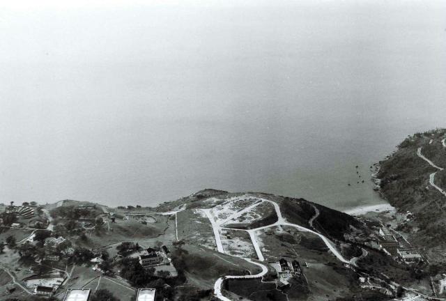
Sandy bay
The small bay on the right should be Sandy bay. The circular road you can see is still there and has Bisney Villas on it. The main road winding around the coastline is Victoria Road.
Far right is the southern slope of Mt Davis so I wonder if the structure you can see at the extreme top right might be Blarney Stone?
Thank you Phil,
Thank you Phil,
I’ll change the title and add an appropriate pin. It could be Blarney Stone, as that is probably the right place. Maybe check it out on the maps. With Google Earth and the maps we should be able to be quite precise. I’ll give it a go. Regards Andrew
Down at the bottom-left edge…
Down at the bottom-left edge are a couple of rectangles with crosses painted on them. They're the wings of Queen Mary Hospital, seen from above. (I hadn't noticed that one wing is wider than the other before!)
I guess that the crosses were to identify the site as a hospital in case of any fighting, though I'm not sure if they were left over from WW2 or more recently applied around the time of the Korean War.
In Ewart Hunt's gallery …
In Ewart Hunt's gallery (1952/3) the distinctive war time camouflage shapes painted onto the Peninsula Hotel were still evident, eight years after the war. I suspect the crosses on the hospital roofs are also almost certainly from the 1941/5 period.
Apologies to Phil for not seeing and replying to his comment in 2019! Yes the circular road is very identifiable as the one where Bisney Villas would be built and the structure at the top right is certainly in the correct spot for the old Blarney Stone house. I don't think there was any other building closer to Sandy Bay on that particular stretch of road.