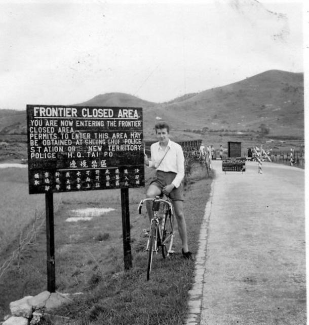
The sign mentions sheung Shui and Tai Po which would be nearby. I cannot tell if the hills agree with the 1952 contour map.
We called it racing bicycle, in Chinese "head-down" bicycle. I tried and found it not as comfortable, perhaps I needed more time to get used to for long distance. Regards, Peter
The 1952 photograph, below, of the Man Kam To bridge from the 1950s gallery does look very similar. In both cases, the bridge is a Bailey bridge and they were used to temporarily(?) replace old bridges destroyed in the fighting in many theatres of war. It also has a ramp up onto it but that was usually the case, and there is a small wooden control post on the right hand side. Mike's photograph shows a different strucutre but his image was taken a few years later between 1953 and 1955. There is no railway line on either image and I don't think that there can have been many border crossings. However, Mike's mountains seem to be quite close and are quite high and I agree that the 1952 map does not show any significant mountains on the Chinese side of the border just there. This 1952 photograph shows some low(?) mountains but they look to be a long way away.
Man Kam To would certainly be within a day's cycling distance on their racing bikes.
Does anyone know how many border crossings there were?
Don't think it is Man Kam To. I think it is a checkpoint for entry into the frontier closed area where a special permit is required. May be somewhere on the Fanling to Sha Tau Kok Road.
I think that you might have narrowed it down. On Google Earth and the street view I moved up the Fanling to Sha Tau Kok road and there are two definite places where the road crosses rivers. One is where it crosses the Ma Wat River, and that mountain top on Mike's photograph definitley matches a very distant view of an identical mountain top. The other, which is very similar is at, I think, Ma Mei Ha where the road crosses the Tan Shan river. I've tried to copy these street view images - but with no success. Any further thoughts?
Well done Moddsey. That's the same bridge as on Mike's photograph - the rounded hill matches very well. Are you able to pin it down to either of those river crosssings on the Sha Tau Kok road? Regards, Andrew
This small bridge just northwest of Lin Ma Hang is a possibility - small, remote, background hills a bit agreeable with the 1952 contour map, but not yet able to find hill-matching current photos. Regards, Peter
It could be the FCA boundary on Ping Che Road at Ta Kwu Ling, I think the road here has always been quite straight and there was a bridge crossing over the Ping Yuen River.
Edit: I'm not sure the small hills match anywhere there though, so back to the drawing board.
Thanks for your contributions. I am now quite lost, not being able to reconcile Google Earth images with the old 1952 map. You all have much more knowledge about that area than I have - never having been anywhere near it in 1957/8, so Ill leave it to you to try to sort it out. I shall be very interested to see your conclusion and hopefully one of you will be able to put a pin on the map so that I can see where the bridge was. In 1981, I managerd on a visit to locate myself on several parts of the road running East from Yuen Long to Kam Tin and further East, but I cannot now fix any of those points on Google Earth - largely because one river has been totally rerouted and none of the fish and duck farms are there to help me. Best wishes, Andrew
Yes, not Au Tau, as it is too far south. As the photo is from the 1950s, one would be looking at the boundaries of the FCA that was established in 1951.
Dear folks, this may not be at the border, but rather a perimeter to an army camp. Here is another candidate (not yet discussed?). The photo might have been taken from the train looking west at Lo Wu camp. The 1952 map shows a bridge here and contours beyond it - gentle slope on the right, looking straight at 163-metre peak, very tempting. Still looking for Google street/farm views -
Yes, the press photo from 1954 that I had linked shows the same location.
I had tried searching for the boundaries of the Frontier Closed Area Order of 1951 but to no avail. As noted here after enactment, this Order came under the Public Order Ordinance of 1948. But I did find a Public Order Curfew Order from 1949 which can be viewed here . The curfew boundaries are given and extend as far south to the crossroads at Au Tau. The Police Magazine of December 1951 about Police Stations in the NT which can be viewed here makes mention of a Bailey type bridge west of Au Tau.
For now, it is difficult to line-up the hills in the photo with the few roads that led to the border at the time. Here is the view of Au Tau Interchange showing how the landscape has changed. Cheers!
I think I may have found it. I believe Peter was correct originally and this is Man Kam To. The hills behind are still there but the eastern high point (on the right of Moddsey's linked image) has been accentuated because a reservoir has been built there making a deeper dip in the ridgeline (so it looks quite pointy compared to the older images). I think this would make the bridge in the photos spanning the Ng Tung River. Similar aspect on Streetview today here.
Of course the river has been "nullahfied" and had its span increased since then to control flooding hence the need for a much bigger bridge.
Excellent detective work and collaboration. If you all agree that it is the Man Kam To bridge as Peter thought, then the rather open white guard hut on the 1952 must have been replaced by the more substantial ‘black’ one when Mike’s photograph was taken c1954?
Now, can one of you place an accurate pin on the map? Cheers Andrew
Dear Folks, thanks to the discussions and Phil's effort, we have arrived at the right spot. I don't deserve credit because I offered Man Kam To at the border as a candidate. I kept searching for a matching ridgeline / contours on the mainland no wonder without success. Regards, Peter
Comments
Which border crossing was this one?
Greetings. Could this one be Man Kam To? https://gwulo.com/node/40970
The sign mentions sheung Shui and Tai Po which would be nearby. I cannot tell if the hills agree with the 1952 contour map.
We called it racing bicycle, in Chinese "head-down" bicycle. I tried and found it not as comfortable, perhaps I needed more time to get used to for long distance. Regards, Peter
Hi Peter,
Hi Peter,
The 1952 photograph, below, of the Man Kam To bridge from the 1950s gallery does look very similar. In both cases, the bridge is a Bailey bridge and they were used to temporarily(?) replace old bridges destroyed in the fighting in many theatres of war. It also has a ramp up onto it but that was usually the case, and there is a small wooden control post on the right hand side. Mike's photograph shows a different strucutre but his image was taken a few years later between 1953 and 1955. There is no railway line on either image and I don't think that there can have been many border crossings. However, Mike's mountains seem to be quite close and are quite high and I agree that the 1952 map does not show any significant mountains on the Chinese side of the border just there. This 1952 photograph shows some low(?) mountains but they look to be a long way away.
Man Kam To would certainly be within a day's cycling distance on their racing bikes.
Does anyone know how many border crossings there were?
Regards, Andrew
Re: Border Crossing
Don't think it is Man Kam To. I think it is a checkpoint for entry into the frontier closed area where a special permit is required. May be somewhere on the Fanling to Sha Tau Kok Road.
Hi Moddsey.
Hi Moddsey.
I think that you might have narrowed it down. On Google Earth and the street view I moved up the Fanling to Sha Tau Kok road and there are two definite places where the road crosses rivers. One is where it crosses the Ma Wat River, and that mountain top on Mike's photograph definitley matches a very distant view of an identical mountain top. The other, which is very similar is at, I think, Ma Mei Ha where the road crosses the Tan Shan river. I've tried to copy these street view images - but with no success. Any further thoughts?
Andrew
Similar Scene
Well done Moddsey. That's
Well done Moddsey. That's the same bridge as on Mike's photograph - the rounded hill matches very well. Are you able to pin it down to either of those river crosssings on the Sha Tau Kok road? Regards, Andrew
Not at this Juncture
Not at this juncture. Will have a look later. Perhaps other correspondents can comment in the meantime. Cheers!
Another candidate for this bridge
Thanks moddsey and Andrew for the feedbacks.
https://gwulo.com/jubilee-buildings?a=1#17/22.55368/114.18082/Map_by_ES…;
This small bridge just northwest of Lin Ma Hang is a possibility - small, remote, background hills a bit agreeable with the 1952 contour map, but not yet able to find hill-matching current photos. Regards, Peter
Ping Che Road?
It could be the FCA boundary on Ping Che Road at Ta Kwu Ling, I think the road here has always been quite straight and there was a bridge crossing over the Ping Yuen River.
Edit: I'm not sure the small hills match anywhere there though, so back to the drawing board.
Hi Phil, Peter and Moddsey.
Hi Phil, Peter and Moddsey.
Thanks for your contributions. I am now quite lost, not being able to reconcile Google Earth images with the old 1952 map. You all have much more knowledge about that area than I have - never having been anywhere near it in 1957/8, so Ill leave it to you to try to sort it out. I shall be very interested to see your conclusion and hopefully one of you will be able to put a pin on the map so that I can see where the bridge was. In 1981, I managerd on a visit to locate myself on several parts of the road running East from Yuen Long to Kam Tin and further East, but I cannot now fix any of those points on Google Earth - largely because one river has been totally rerouted and none of the fish and duck farms are there to help me. Best wishes, Andrew
stumped
thought it might be Sandy Ridge but now I am seeing things. This one may take some time.
Au Tau
Philk - would the scene be this ?
FCA
I'm not sure that the FCA ever came down as far as there, I think it's western most limits ended somewhere around Maipo?
Re: FCA
Yes, not Au Tau, as it is too far south. As the photo is from the 1950s, one would be looking at the boundaries of the FCA that was established in 1951.
b At the Border?
Dear folks, this may not be at the border, but rather a perimeter to an army camp. Here is another candidate (not yet discussed?). The photo might have been taken from the train looking west at Lo Wu camp. The 1952 map shows a bridge here and contours beyond it - gentle slope on the right, looking straight at 163-metre peak, very tempting. Still looking for Google street/farm views -
https://gwulo.com/jubilee-buildings?a=1#15/22.5184/114.1124/Map_by_ESRI…
Regards, Peter
1954 Photo
Another photo from 1954 showing more of the hills.
Hi Moddsey. That has to be
Hi Moddsey. That has to be the same location as on Mike Sykes' photograph - but where is it on the map? Can you all pin it down? Thanks. Andrew
Hi Andrew
Yes, the press photo from 1954 that I had linked shows the same location.
I had tried searching for the boundaries of the Frontier Closed Area Order of 1951 but to no avail. As noted here after enactment, this Order came under the Public Order Ordinance of 1948. But I did find a Public Order Curfew Order from 1949 which can be viewed here . The curfew boundaries are given and extend as far south to the crossroads at Au Tau. The Police Magazine of December 1951 about Police Stations in the NT which can be viewed here makes mention of a Bailey type bridge west of Au Tau.
For now, it is difficult to line-up the hills in the photo with the few roads that led to the border at the time. Here is the view of Au Tau Interchange showing how the landscape has changed. Cheers!
Man Kam To
I think I may have found it. I believe Peter was correct originally and this is Man Kam To. The hills behind are still there but the eastern high point (on the right of Moddsey's linked image) has been accentuated because a reservoir has been built there making a deeper dip in the ridgeline (so it looks quite pointy compared to the older images). I think this would make the bridge in the photos spanning the Ng Tung River. Similar aspect on Streetview today here.
Of course the river has been "nullahfied" and had its span increased since then to control flooding hence the need for a much bigger bridge.
Thanks everyone.
Thanks everyone.
Excellent detective work and collaboration. If you all agree that it is the Man Kam To bridge as Peter thought, then the rather open white guard hut on the 1952 must have been replaced by the more substantial ‘black’ one when Mike’s photograph was taken c1954?
Now, can one of you place an accurate pin on the map? Cheers Andrew
Marker
here is the approximate place. https://gwulo.com/node/45459
Looking at the 1952 map overlay, the bridge here had a 90ft span at that time.
Frontier Check Point
Dear Folks, thanks to the discussions and Phil's effort, we have arrived at the right spot. I don't deserve credit because I offered Man Kam To at the border as a candidate. I kept searching for a matching ridgeline / contours on the mainland no wonder without success. Regards, Peter
Good Work
Good Work Phil!!
I have followed all the
I have followed all the comments with great interest. Google Earth Street View looks very different! Many thanks Andrew
Close-up of the Checkpoint at Man Kam To