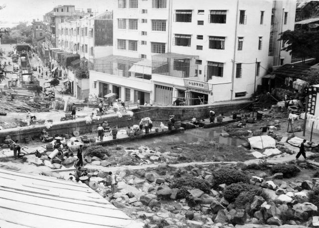
This looks very much as Tai Hang would have been in the early 1950s. Zooming in on this image I believe that the Causeway Bay typhoon shelter's breakwater(?) is just visible at the top left. (Andrew S)
Date picture taken
1953
Gallery
Shows street(s)
Comments
Re: Tai Hang
Hi There,
The street with the nullah is Wu Sha Street. The street is still there but the nullah went underground. That street name actually means washing fabrics in the stream thus what the photo shown in the foreground would be somewhat of its namesake literally.
T
Thank you T,
Thank you T,
I have added a pin on the map at the top end of Wun Sha Street, where the laundry seems to have been. If the laundry was at the top of Wun Sha Street, it looks on Google Earth as though the area immediately above the 'dam' might still be undeveloped. Are there any remains of the laundry slabs up there? Best wishes Andrew
Re: Wun Sha Street
Hi Andrew,
We may be able to line up the photo a bit. Back then the nullah was in the middle of Wun Sha Street. Based on the point of view the photographer may be standing in a straight line towards the middle of the nullah. Unfortunately all the building on eastern side had been rebuilt and could not be used for matching. But the slope may be. If you use Street View to go up towards the end, there is a public park\playground on the western side with a stone retention wall that may match the time frame. The government did not build retension like those anymore.
T
Hi T,
Hi T,
I have moved the pin to the place where the playground is and where there is the bend in Wun Sha Street. The photograph suggests that there was a straight line view down the street towards Causeway bay. Is that better? Andrew
Re: Wun Sha Street
Hi Andrew,
The layout of the street blocks had not change much. There are still a few older houses on the western blocks today. If you 'walk' around in Google Street View you shoudl be able to see them. Last time I was in the area I spotted a few of those low buildings with ceremic tiled roofs, traditional village houses.
The would be likely the location as the slope suddenly rises around there. But that would be quite close to Tai Hang Road above. The photographer may have actually stood at Tai Hang Road back then. You mentioned some of your colleagues stayed at Wang Fung Terrace before. Maybe the photo was taken on their way down?
T
Hi T,
Hi T,
Rhe R.A.F. had moved out of Wang Fung Terrace a few years before Peter was in Hong Kong. However, he like most of us would have gone to see the Tiger Balm Garden and would most likely have walked up the Tai Hang Road to get there. So, if he looked down he would probably have seen the laundry. Regretfully, I didn’t! Best wishes, Andrew
Re: Wun Sha Street
Hi Andrew,
If we use Satellite view the approximate position should be quite clear. The only wide street as seen is Wu Sha Street with the underground nullah now. If we trace the stream using older maps, the stream may actually go up right next to the Tiget Balm Garden just across the road. There is a wide pedestrian bridge\steps linking Wun Sha Street and Tai Hang Road for decades. But back then, there may be other narrow foot paths along the slopes.
T
Hi T,
Hi T,
The reason I placed the pin on the bend is that on Peter's photograph the buildings (including the Wing Lee Carpenter one) on the right where the road ended are not in alignment with the lower part of the street. I have just noticed on the 1952 map that there is a thick blue line crossing the stream slightly uphill from where I have inserted the pin! That must represent a small 'reservoir' above a dam and surely the place for the laundry. On the 1952 map there are also 3 dashes heading uphill from more or less next to my pin to meet the Tai Hing Road - an ideal path from which to photograph the laundry and probably the route taken by Peter and the rest of us up to the Tiger balm Gardens. Any thoughts? Best wishes, Andrew