Current condition
Demolished / No longer exists
Date completed
(Day & Month are approximate.)
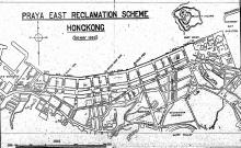
A map from the 1940s (Plate 3-5b, Mapping Hong Kong) shows this pier at the end of Fleming Road. I'm not sure exactly what the 'G.P.' stood for - 'General Pier' perhaps? It's where rubbish was loaded onto barges.
Any ideas what happened to the rubbish after that?
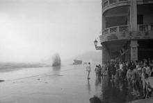
Photos that show this Place
1920
1941
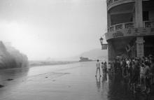
1941
Comments
Refuse Boat Pier
From the 1930 PRAYA EAST RECLAMATION SCHEME. FINAL REPORT.
(d) A Refuse Boat Pier projecting 58 feet from the Cope at the end of Fleming Road. This pier is constructed in sloping blockwork and provides 60 feet of berthage on its outer face having a depth of 15 feet of water below Ordnance Datum.
As other piers in this area, it was opened in 1929.
Re: G. P.
G. P. may refer to a Garbage Pier.