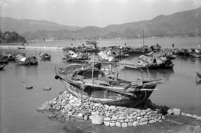
I cannot identify where Ted took this photograph. It would seem to be in a typhoon shelter but the shoreline is unfamiliar so I don't think that it is anywhere on the Eastern part of the Island.. The range(s) of hills might be a clue and it looks very much like a road gradually descending the distant hill. The building on theheadland at mid left looks like a substantial house. In the mid 1950s, old and presumably non seaworthy sampans were often beached, and used as workable homes, but I don't recall ever seeing one perched on an artificial stone 'island'. Any clues as to the location?
Date picture taken
1956
Gallery
Comments
Re: A causeway running across
Hi There,
There seemed to be a causeway running across the photo, wide enough for single lane vehicle traffic. I believe I saw a small vehicle on it If this is the case and back in the 1950's, there didn't seem to be too many choices. I tend to agree the ridges may be the biggest clues.
Thanks & Best Regards,
T
Hi T,
Hi T,
Yes, I hadn't spotted it. There is a small (and very old) car near the left hand side of the causeway and it is heading off to the left. There must have been a bridge on that narrow road to allow the sampans to leave the typhoon shelter, if that's what it was, and get out to sea.
I suspect that it might be somewhere in the New Territories, possibly but nowhere too remote as Ted is unlikiely to have had his own transport.
Andrew
Sampans Hong Kong
Greetings. Given the height and closeness of the camera to these boats, I wonder if this photo was taken from the train while Ted was heading north. I am travelling on the Google car along the rail to test my luck and patience. The sun's shadow appears to exclude the south side of HK island and the west side of New Territories. That long line just below the redige line, was it a road or natural? One street view photo from the current Tai Po Railway Pier looks tempting, and the railway track (original?) just south of it. Regards, Peter
The closer line of the hills
The closer line of the hills on the horizon is the ridge line running down from Cloudy Hill, today separating Tai Po and Hong Lok Yuen, however the causeway in front is not the Tai Po Railway Pier but rather the causeway linking Tai Po and island house. I have included an aerial photo of the causeway from the 1930s below:
I believe the building on the left on top of the hill in the original photo is the Tai Po Bungalow. The road on the hillside would therefore be Wo Hop Shek Road.
Sampans by Tai Po (1950s)
Thank you Herostratus for identifying the site with solid (and water too) proof. Regards, Peter
1963 Tai Po
Similar scene but passed Island House.
Tai Po
Thanks, everyone for sorting out where that image was of. Looking at Google Earth, now, I'd never have been abole to sort it out!
Andrew