Current condition
Demolished / No longer exists
Date completed
Approximate location of area marked "Rifle Range" on map, dated 1924, at Page 181 of Mapping Hong Kong.
Photos that show this Place
1900s
1910s
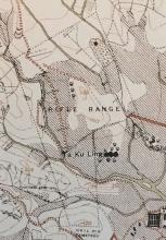
1924
Comments
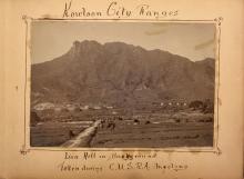
1920's Rifle Range in North Kowloon
This photo appeared in the Eternal1966e website recently, dated to the 1920's.
The outline of the Lion Rock is unmistakable, so it was obviously taken just to the south of it in north Kowloon. Between the camera and the point where the land starts to climb towards Lion Rock is a long flat length of grassland with short, parallel ridges running across it at intervals. Under focus a horizontal line of squarish, light coloured, objects can be seen just as the land begins to rise.
It looks like a rifle range. The squarish objects could be the targets and perhaps the parallel ridges were firing points set at different fixed distances from the targets. In effect Lion Rock was the butt to stop the bullets.
Another photo appears on eternal 1966e, also dated to the 1920's, which i think shows the view looking in the opposite direction, back down the Range.
The parallel ridges are more obvious from this direction. Note the stream running down the right side and low hills on the left side of the Range.
This extract from the 1924 map at Page 181 of Mapping Hong confirms that a Military Reserve occupied the southern slopes of the Lion Rock (top left) and ran most of the way towards Kowloon City (bottom right).
The southern part of the Reserve is marked "Rifle Range". It's roughly mid-way between the Lion Rock and Kowloon City. I think that equates to somewhere in the vicinity of Junction Road Park, Lok Fu, Wang Tau Hom today, so have put the "Place" marker there. Here's a further blow up of the Range. I think the area seen in the two photos runs between the stream that runs up the western boundary of the Range and the low hills upon which the word "Range" is written.
Good Work
Good work. I had made some comments here about the Rifle Range and the 1950s RAF Explosives Area northweat of Kai Tak. Not sure if the two were connected.
Rifle Range
Thanks Moddsey. Interesting to see that the Rifle Range was still there in the 1930's and was serving a duel purpose - golf course. Hopefully not at the same time!
Rifle range
Thanks for adding the extra information about this. Looking at the maps there is still a rifle range shown at this location on the 1952 map:
http://gwulo.com/node/34468?a=1#17/22.34043/114.19032/Map_by_ESRI-1952_…
1930s Kowloon City Rifle Range
Re: Morse Park
Hi There,
The Wiki entry for Morse Park cited it used to be a rifle range and once hosted the Hong Kong Scouts Golden Jubilee Jamboree back in the 1960s. It didn't mention about the Explosive Ordinance storage though.
Might be difficult to back trace the actual boundary today as the area in general had been redeveloped over the past decades.
T
Kowloon City Ranges
They were already in use when
They were already in use when Tim's 1910 photo was taken, so I've pushed the completion date back from c.1920 to c.1910.
Notice 320 in the Government Gazette from 1914 mentions several ranges, including one of the two shown above:
| From Wong Nei Cheong Gap |
\ Southerly direction. /
Rifle Range
There is a police station on the lower right hand side of the map, so it would be the old Kowloon City Police Station, working Northbound, it should be the Osborne Barrack? So the Range was inside Osborne Barrack, does it make sense?
Not Osborn barracks
Assuming Nga Tsin Wai hasn't moved much in the last 100 years, I don't think that police station on the map corresponds with the modern day Kowloon City Police Station. This one looks closer to opposite where the modern day Shek Ku Lung playground stands.
Re: The Police station stated in the old Map
Hi Phil,
I guess we could use Ng Tsin Wan and the old Wall City to triangulate the police station anyway. The nullah could also be used as another reference. My estimation would put it on the SE side of present day Prince Edward Road, in the old site of the Kai Tai Airport. The old map was older than the airport, right? I supposed the KIL lots were of the Kai Tak Bund?
T
I've had a go at the location
I've had a go at the location of the old Police Station, using the maps at http://www.hkmaps.hk/mapviewer.html
See https://gwulo.com/node/41177
I've added an outline to the
I've added an outline to the map to show the ranges, based on Map 1922 at http://www.hkmaps.hk/mapviewer.html
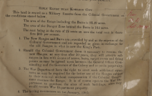
Rifle Range near Kowloon City WDL18
Rifle Range near Kowloon City, Page 15 of《Military Property, Reserves, And Lettings in HONGKONG》- Colonel J.F.LEWIS 1905
This land is rented as a Military Reserve from the Colonial Government on the conditions stated below.
The area of the Range including the Butts is 93.20 acres.
The area of the Danger Zone behind the Butts is 162 acres.
The rent being at the rate 25 cents an acre the total rent is therefore $65 per annum.
1905 Completion date
Para.7 of The Report of the Director of Public Works for 1904 (Gov Gazette Notification 254/1905) mentions that an area of land of just over 255 acres near Kowloon City was leased to the military for ten years for use as rifle ranges and reserve in exchange for them giving up the range at King Park and states that "The Ranges are practically completed" - which all agrees with Jamesho's post of 25-8-2021 above.
The construction completion date can be moved back to 1905.