The wartime map shows this pillbox on the shoreline.
The pillbox is mentioned several times in documents related to the Telegraph Bay redevelopment, which was later named Cyberport. First there is the 'Final EIA (Environmental Impact Assessment) Report for Agreement No CE 92/97' which says:
10.5.5.2 To the south of the Telegraph Bay Development site lies the Aberdeen Waterfall and a nearby Wartime Pillbox with an adjacent bunker. Either the Waterfall or the bunker may be disturbed by the proposed Telegraph Bay Development, with the proposed Southern Access Road passing some considerable distance away from them both. Views and access to these two facilities may not be impeded by the Telegraph Bay Development, although clearly when viewed from the south, the Telegraph Bay Development may be seen in the backdrop.
Then the "Environmental Impact Assessment Study Brief No. ESB-044/1999", for the southern access road (the U-shaped road in the satellite view above) includes:
3.2 The Scope. [...] The EIA study shall address the likely key issues described below; [...]
(iii) the potential impacts to the historic military pillbox at the Waterfall Bay.
and
3.3.6 Impact on Cultural Heritage
The Applicant shall assess any direct and indirect impacts on any sites of cultural heritage, including the historic military pillbox at Waterfall Bay, [...]
If you have any memories or photos of this pillbox, please leave a comment below.
Photos that show this Place
Comments
Pillbox 6, photosynth-style
As a break from the struggles with the KCR Terminus photosynth, here's one of an existing building. A lot easier to get the photos!
Here are some different things to try.
First the basic panorama. There is a right-arrow on the right edge of the box. Click that repeatedly to look around the beach.
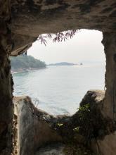
Next try pressing the '.' key repeatedly. You're seeing the photos as I took them - in effect you're seeing the place as I did as I walked around. Keep going long enough and you'll see inside the pillbox.
Now navigate so you are looking at a photo that has a clear view of the outside of the pillbox. Press the 'p' key and behold, the Matrix! In this view we've removed all the photos (pressing 'p' toggles this in any photosynth). All that remains are the key points that photosynth uses to match up all the different photos. Move your mouse to the centre of the box and you should see something like a donut appear. Click it and drag it up and down, left and right to see a 3-D view of the pillbox.
Have fun!
Lyon Light #6
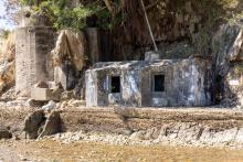
We now know that the tall structure on the seaward side is the remains of the Lyon Light shelter.
The low building below it should then be Pillbox #6. It has the cirular opening in the roof that we've seen before, but it doesn't have loopholes like other pillboxes we've seen. From the blue paint job it looks as though this building was lived in by squatters at some point. Maybe they also chipped out the loopholes to make them into larger windows?
Rob's notes
Year completed is: Approximate
Condition at last visit: Intact
Date of last visit: Jul-1996
Ref: ROB-00605
Other: Poor condition
Pillbox 6 photo
Here is a photo from 2016, unfortunately not downloadable.