Current condition
Ruin
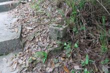
The position of the marker on the map is approximate, but if you're walking up the trail from the reservoir, the r-shaped concrete is on the right of the path.
I didn't see any others nearby, but I didn't make a thorough search.
Photos that show this Place
2016
Comments
"r" shaped structure
This "r" shaped structure is approximately 150 meters uphill from the group of British WWII bunkers at Aberdeen Upper Reservoir described at;
www.gwulo.com/node/2410 ,
www.gwulo.com/node/2176 ,
www.gwulo.com/node/4175 ,
www.gwulo.com/node/2177
and the water tank at www.gwulo.com/atom/23069.
Similar to those seen elsewhere, I suspect this "r" was one of a series forming part of the defensive fence around the military area below. It's real tiger country around the "r" so I didn't try to find out if there were any more up on the hillside. However, there is one on the waters edge almost opposite the entrance to the bunkers at www.gwulo.com/node/2176 . It's been uprooted, possibly from a hole of approximately the same size about 2 meters above it.
Cables
I recall David saying that these r's are markers for underground cables. And the top of the r apparently points towards the direction of the cable. Do you think they usually correlate to defensive lines/fences? It is true that I almost only ever see them near British PB's // Bunkers.
Regards
Cables / defences / both?
Gw found a group of these arranged so that they don't make sense as cable markers, but looked in the right arrangement to be anchors for barbed wire.
Others on the hillside looked more like markers for cables, to me at least .
So I'm hedging my bets at the moment, and guessing there are two different types, built at different times for different purposes, but that just happen to look very similar. Corrections welcome!
Regards, David