For years and years and years I thought this was a bridge built by the Water Works Department. Recently I looked more carefully and found water flowing under the bridge deck, which means that it is actually an aqueduct. It must be very old because I remember crossing it in the 1960s when going for morning exercise with my grandmother, and at that time it looked very old already. It is very elegantly built and should be declared historic monument!
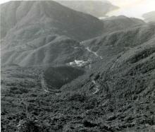
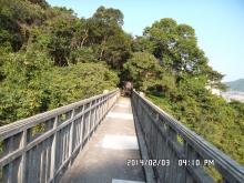
To get there, start from Tai Tam Rd near Hing Man Estate. Walk south along the left side of the road. You will see a green fence between you and Hing Man Estate. Keep walking until the fence ends and you can turn left. After turning left and going a bit further, you will soon see a catchwater. Walk along this catchwater and eventually you will reach the aqueduct. It is built over a deep gorge, with beautiful arches.
There is also an abandoned building nearby. I believe it was a quarter for workers working for the Water Works Department. (A distant relative of mine lived in a similar building near Kowloon Reservoir in the 1960s)
Photos that show this Place
Comments
I just traced the catchwaters
I just traced the catchwaters on a map, and this aqueduct is part of a long route. It starts on the hills above Shau Kei Wan, then follows the contour clockwise til it reaches your aqueduct. After the aqueduct it joins a channel heading south that disappears into a tunnel, runs for 1-200m underground, then emerges again south of the Taitam / Sek O Roads roundabout. That follows a natural riverbed downhill til it meets a small dam, and a new catchwater takes the water around and in to the Tai Tam Tuk reservoir.
Quite a journey!
another mystery
I remember faintly that I have also walked along that part of the catchwater above Shau Kei Wan and Sai Wan Ho with my grandparents (and their morning exercise group, the members of which must have all passed away, or over 100 years old by now!) one foggy spring morning in the late 1960s and we eventually reached (actually we trespassed!) the Mt Butler HF Radio Receiving Station!
After more than 50 years I tried to locate this route again 2 years ago. Starting from the Chai Wan Rd - Tai Tam Rd junction (as my grandparents did 50+ yrs ago), I went uphill and found the catchwater still there. Along the way you can enjoy great views of the part of the city and harbour below. There must have been many landslides over the years and the trail did not resemble what I remember. Even the vegetation is different.
It is still possible to reach the Mt Butler HF Radio Receiving Station eventually. Today, the place is run by a private company, but back then, it was probably a military installation. (The world was politically unstable back then - Vietnam War, Cold War, Cultural Revolution, 67 riots in HK...)
The mystery is that I seem to remember seeing, in the vicinity of the Mt Butler HF Radio Receiving Station of today, a school and perhaps residential buildings for the personnel and families of the British military. The place was landscaped beautifully, and for a while I was fascinated because, walking out of some thick fog, I thought I had gone to Europe.
That was more than 50 years ago. Today, there are still a few abandoned buildings in the area, and one of them does look like a school (Lat. 22.2758, Long. 114.2026).
(To get there, go north east on Mt Butler Rd until it becomes Sir Cecil's Ride. Keep going until you reach almost the very end of the paved road. The old buildings are on your left. I hope I can go and take some pictures before they get demolished.)
Re: foot path to Siu Ma Shan cloes to Mount Butler radio station
Hi there,
I guess the foot path to the radio station could be Sir Cecil's Ride, which is still opened to the public. You should be able to reach an intersection of paths where there are radio masts around. I guess the issue is the foot path along the NW and\or N slopes of Mount parker.
If you check the Geoinfo Map you should be able to see dotted line foot paths along the slopes. But that means the paths maybe much overgrown. You may start for Sir Cecil's Ride from Mount Parker Road down at King's road.
T
ps Sir Cecil's Ride overlaps with Mount Butler Road near the Quarry (now EOD depot) until it branched off towards Wong Nei Chung Gap.
There's a version in a
There's a version in a Chinese website saying that an engineer believed this bridge was built for the workmen... for which I keep my doubts. On the other hand, even if it may be an aquaduct, one needed not spent more for the railings on both sides, perhaps there're still some other reasons reasons behind.