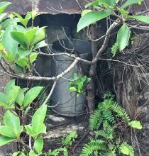
This small structure stands beside the path from Wong Nei Chung Reservoir to Violet Hill.
")
After the path has crossed the dam itself and dropped down past the weir, then it's about a hundred meters or so on the left after starting to climb the hill. It's protected by a high wire mesh fence but there's no sign saying what it is. The gate is unlocked, but the bolt has rusted and wouldn't move so I couldn't get closer.
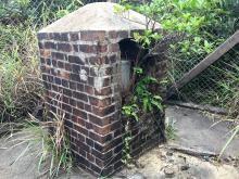
Basically it seems to be a brick structure with an apperture containing a metal cylinder. Here's a close-up.

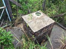
Here's the view from above from the other side.

I assume the hole in the top leads to the cylinder below, and by now am thinking it's an old rain gauge, i.e. thingy to measure rainfall.
The report "Weathering The Storm" at http://www.weather.gov.hk/publica/gen_pub/WeatheringTheStorm-4.pdf
tells us that, "in 1938, the Observatory co-operated with the Waterworks Office of the Public Works Department to collect rainfall data in major reservoirs", including Wong Nei Chung, so perhaps this is the rain gauge that was used.
Grateful if anyone could confirm or shed any further light, particlularly C.M., our resident expert on all things meteorological.
Photos that show this Place
Comments
Wong Nei Chung Reservoir Rain Gauge(?)
A Hedda Morrison photo shows there was activity at this site in 1946/7, but accessing her pics online is always a bit troublesome.
1. Go to the searchbox of the Harvard Library site at http://via.lib.harvard.edu/via/deliver/advancedsearch?_collection=via .
2. In the top box type "hedda morrison".
3. In the next box down type "aberdeen reservoir".
4. Press the search button.
5. A choice of four photos appears. The one I'm talking about is the first on the left, entitled "Aberdeen Reservoir".
Actually, it's not Aberdeen Reservoir, but Wong Nei Chung Reservoir, and was taken in 1946 or 7 probably from somewhere on Tai Tam Reservoir Road near where Parkview now stands overlooking Wong Nei Chung Reservoir.
Look at the hillside rising above the left side of the dam wall. There's an area cleared of vegetation that shows up as light in colour. If you focus in on the right side of this cleared area you can see what appears to be a small, rectangular shaped, plot surrounded by a low wall. I think this is the site on which the suspected rain gauge now stands, but there's insufficient detail in the old photo to see if it was there in 1946/7.
On a different topic, between the rectangular walled area and the dam, a line of posts can be seen running across the hillside. Presumably they supported a fence stopping access to the Reservoir. The posts are still there today, their line tracked by inner and outer lines of those small concrete "r" shaped structures discussed previously at www.gwulo.com/node/1953, www.gwulo.com/node/19380 and www.gwulo.com/node/2034 . Again, as the "r's" track the fence, their function was probably related to it, and the most likely function for an "r" is to act as an anchor for coils of barbed wire that would increase the effectiveness of the fence.
Rain Gauge
Greetings. Thanks gw for the photo of the rain gauge. Weather folks continue to improve forecast to help us plan our daily activities. We now have 7-day forecasts - temperature, wind and sun shine, quality, and more - which are fairly accurate more often than not, and same can be said of rain and snowfall amount. And regional forecasts that "outlook" different months into the future with varying reliability.
Instruments used to collect a wide range of weather parameters are constantely being improved. Howver, the rain gauge like this one needs no improvement and will operate fine for many more years as long as its opening remains intact and every raindrop falling into it gets into the bucket, if they don't mind travel to the site and manually measure the content. And, of course, allow no tall vegetations around it or change in the immediate area's topography. Regards, Peter