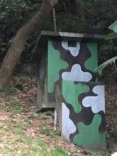
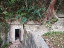
West Brigade HQ exists as ruins in good condition today. The site was constructed by the British Military in the 1930s as a strategically invaluable link between all 4 quarters of the island and the commanding split of East/West of the island. Constructed structures included a string of sunken bunkers, low defense walls, a camouflage defense pillbox and a number of other defensive structures including trenches and shooting position. A smaller NCO bunker with a notable flagpole exists below the current gas station, slightly separated from the other structures.
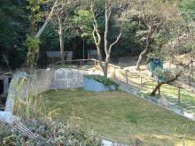
Most of the original structures exist today, visible from Wong Nai Chung Gap Road, residing next to the Esso Gas Station. The main series of structures next to this gas station are accompanied by a commemoration plaque and historical billboards as part of the Wong Nai Chung Gap Historical trail. This area was recently cleaned up and the area is quite serviceable. A bunker was demolished for the construction of the Gas Station, but most still remain intact.
The West Brigade HQ was involved in the engagement at Wong Nai Chung Gap, in the Battle of Hong Kong. The Battle of Wong Nai Chung Gap was the largest sustainment of casualties in a single day, on both sides, in the whole conflict. And, its subsequent capture by the Japanese effectively led to the downfall of Hong Kong Island, splitting the forces there in two (Separating East/West Brigades). At the time of this Battle, the Wong Nai Chung Gap area included defenders of the Middlesex Regiment, The Winnipeg Grenadiers and the HKVDC. Brigadier Lawson was present at the HQ and involved in the Battle.
On December 18th, the Japanese had landed around present day Taikoo and had made advances into the North Point area. They moved up towards Wong Nai Chung Gap from Braemar Hill through the primary use of Sir Cecil's Ride, but also through Wanchai and Happy Valley. Primary engagements occurred around the area of Jardine’s Catch-water, where there were two pillboxes manned mainly by Middlesex Machine Gunners (JLO1/2). Royal Scots on Mount Nicholson also became engaged in fighting the Japanese advance units on the adjacent Jardine's lookout, but also those coming up Happy Valley/Wanchai area.
The superior Japanese force soon closed in on the West Brigade HQ, before the staff and other units could be evacuated. The conflict ensued for a long period, with defenders holding out and inflicting heavy casualties through the use of heavy machine gun fire. The defenders were surrounded and pinned down, with few units able to get through to relieve them. The defense finally deteriorated after nearly every defender was either killed or wounded. Even Brigadier Lawson made a call to Fortress HQ, saying he was going outside to ‘fight it out’ and was killed in action. Few stragglers managed to escape and the remainder of the soldiers (almost all wounded) were taken prisoner.
The Japanese held the position against a number of counterattacks, and were able to effectively split the Commonwealth forces in Hong Kong Island. This was key factor that led to the downfall of the colony on the 25th December Surrender.
NOTE.
-I am an amateur historian, and not all information might be completely correct. Please feel free to add corrections or ask questions in the comments.
-I could not find a page on this site on Gwulo, only a marker and info on the St. Johns ambulance memorial and the Blacks Link Pillbox. So I added this one. If there is any existing info, please link it through the comments section
Photos that show this Place
Comments
West Brigade HQ [c.1934- ]
Hi Iloveoldhk,
Thank you for the informative article. Do you know why the Canadian flag is hoisted outside the NCO bunker, and what the little triangular sign above the bunker says?
Also, I believe there were military structures across the road on the current HK Cricket Club grounds. What was destroyed when the club was built?
Thanks.
Hi. Great to hear from
Hi. Great to hear from someone about this article. The Canadian flag housted and the triangular sign were there only for a Canadian War Memorial day a number of years ago, since many Canadians fought in the area. (I believe the triangular sign was a 'ensign esque' flag of X company Winnipeg Grenadiers; or something of that sort, denoting the combat unit). The flagpost exists still, but that picture is quite special in that sense haha.
The gas station on that side (next to the current West Brigade HQ) used to be a set of bunkers that were demolished. But, other than that, I have no evidence that there were structures destroyed when the club was built. There are some old cement ditches and drainage systems that are on a small dead end road between the cricket club and a gas station next to it, but nothing expecially indicitive of military positions. It is likely there was something there at the time, but most of the defensive positions were on the opposite side of the road.
If you have any more questions, please feel free.
Triangular Flag
Actually. After further scrutinization, the triangular sign appears to be the Winnipeg Grenadier's emblem.
As Shown here.
https://www.google.com.hk/search?q=winnipeg+grenadiers&safe=strict&espv…
Philip Cracknell's latest
Philip Cracknell's latest blog post has more information about the West Brigade HQ, and its current condition:
http://battleforhongkong.blogspot.hk/2018/01/west-brigade-hq-current-co…