Current condition
Ruin
Date completed
Year completed is: Approximate
Condition at last visit: Intact
Date of last visit: Apr-1995
Ref: ROB-00719
Other:
Photos that show this Place
2014
2014
2015
Comments
LL & PB 20 at South Bay
A few days ago I visited South Bay to try to work out where Pillbox (PB) 20 used to stand. I'm not sure that I succeeded, but nevertheless came across plenty of items of interest.
On the theory that all the coastal PBs were built close to their respective Lyon Light (LL), i.e. searchlight, shelters, I started at the South Bay LL shelter. Easiest access is from South Bay Road. Just hop over the wall at the lamp post on the right.
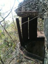
The LL is visible from the road. The slope down to it isn't badly overgrown, but there are plenty of loose rocks. From the roof of the LL it's apparent that it once enjoyed a commanding view of the whole beach.
The LL shelter has been quite badly damaged, particularly around its entrance, but I don't know why, when, how or by who?
The coastal PBs and their respective LLs communicated via metal voice pipes between the two. In this instance the pipe is missing, so no clue on the location of the PB from that source. Some sites had steps running between the PB and LL, e.g. PB/LL's 8, 14 & 21, but there's no sign of that here. The slope infront of the LL has been "shotcreted" covering any evidence of a path that may have once existed.
Being unable to find a way down to the beach, I contoured along the slope to the south-east of the LL. About 30 meters from the LL, on the same level, is this;
A hole has been dug into the slope and a low wall of "breeze blocks" built across its lower lip facing the beach. As breeze blocks are frequently seen at WWII British military sites, its proximity to the LL, and the lack of anything else nearby that it could have been part of, I'm fairly confident that this is a British Army trench dating from prior to the Second WW.
Continuing at the same level along the slope for another 20 meters brings you to another trench.
Being very similar to the first, but without breeze blocks, I presume this one was dug at the same time and to serve the same purpose as the first. I wonder if they were dug prior to the construction of the PB and LL and subsequently became redundant, or if they were dug to compliment the PB and LL?
A few meters past the second trench are the remains of an old concrete staircase. It's broken and covered in places, but enough remains to see that it originally ran from South Beach Road down to the back of the beach. This old concrete post stands near the top of the stairs.
I presume the metal fittings on the side of the post were fastening points for strands of a wire or barbed wire fence. Only one other concrete post stands nearby, but there are a number of small concrete structures shaped like the letter "r".
The "r's" seem to run in two lines from the concrete post mentioned above. One line of "r's" drops directly down to the beach. The other runs just below and parallel to South Bay Road, behind and around the LL before dropping down to the beach. In effect the "r's" surround the area containing the LL, both trenches and presumably the PB assuming it was situated close to the LL.
To the west of the LL, close to where the "r's" reach the beach, is the remains of an old barbed wire fence.
I think I've seen similar "r" structures elsewhere, but can't recall where. Wherever, I hadn't previously considered their purpose and am now wondering what function they served? One of them had a strand of barbed wire attached.
As the "r's" seem to surround this military site, and to be closely associated with barbed wire fencing, could they be anchor points for rolls of coils of barbed wire protecting the PB, LL and trenches? If so, and they date from before WWII, it seems strange that the barbed wire attached to the "r" pictured above hasn't rusted away.
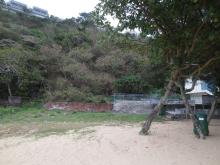
The north end of South Bay Beach is occupied by bbq sites, beach huts and foundations of unidentifiable old buildings, none of which show any of the distinctive characteristics of a coastal pillbox. However, one small area of the rock face at the back of the beach has been concreted.
It's a different type of concrete to that used for "shotcreting" higher up the slope. It looks like the entrance of a tunnel has been blocked. It's almost directly below the LL, but a little further towards the back of the beach, which was the normal arrangement for coastal PBs and their LLs, e.g. PB/LL 6,8,14,21,22,30,31,32 & 35. Considered together with the Japanese Army's habit of tunneling behind British Army instillations, may indicate that PB 20 was sited infront of the tunnel entrance.
That was it. Comments from anyone who can throw more light on anything mentioned above would be most gratefully received.
I'm curious about those
I'm curious about those concrete r shapes too. In other places I've seen them with the arm at another angle, not a right-angle like these. I've wondered if they're some sort of markers for underground cables, but it would be good to get a firm answer.
Regards, David
LL 020 South Bay.
Can't help with the L shaped blocks, but can offer some comments on the PB/LL.
The whole Beach Defence Unit was "wired in". A high wire fence supported on steel or concrete posts surrounded the back and sides, whilst the beach and water was protected by three layers, a double apron fence at high water, another double apron fence at mid water, and free concentina wire at low water. This was the recommended style, but whether it was followed closely I don't know. The last time I checked, some years ago, PB 30 at Turtle Cove Beach had a considerable portion of the side and back fence still standing, mostly on the south side of the LL Shelter.
The trench(es) were probably what was referred to as the Alternate position(s), which gave some degree of protection and enabled the PB crew to fight on should the PB itself become unusable.
The PB was directly in front of the LL, on the edge of the beach. I was never able to find its remains, however a tiled floor barbecue area sits on a concrete base, having similar dimensions and shape to a PB, in that position. I presume that if one was enthusiastic enough to move several tons of sand, that could be confirmed.
LL 020 South Bay
David,
Yes, I too am sure I've seen the "r" structures elsewhere, but I can't remember where, which makes it impossible to put them in any sort of context from which to draw conclusions regarding their purpose. I, like you, had associated them with underground cables, but I don't know why. In the back of my mind there's also some connection to railways. No idea why.
Apologies for posting some of the photos the wrong way around and thanks for your patient assistance in trying to guide me in how to correct them.
Rob,
Thanks for the interesting additional information. I'll go to have a look at PB & LL 30 to see if the old defensive fence is still there.
I remembered where I saw
I remembered where I saw other concrete "r" shapes when I passed them again this morning. These three are on either side of the Hong Kong trail, shortly after leaving Parkview on the climb up to Jardine's Lookout.
They all appear to have had "5/3" or possibly "15/3" scratched into them while the concrete was wet. I'm still not sure what they were used for.
Regards, David
Wong Nai Chong Gap
I'm afraid they are nothing more than VERY post-WW2 HK Telephone Co. underground cable marker stones, David!
I realize that that info will probably come as a disappointment to you, but so be it.
They are actually dotted all over the island. I know of dozens of them which I can show you.
underground cable marker stones
Thanks, good to know what they were for. Does the direction they point in show the direction the cable runs?
Regards, David
Oh "r"
Ah yes, or more appropriately, "r" yes, we return to the question of the provenance of those pesky little concrete "r" shaped structures that keep popping up all over the place.
To recap, the first time I consciously met one was during a visit to South Bay where it was skulking with its mates in the undergrowth around Pillbox & Lyon Light 20 (my post of 3-3-2015 above). Next was an encounter in Little Turtle Cove where they'd formed a double-line surrounding Pillbox & Lyon Light 30 (my post of 12-3-2015 in www.gwulo.com/node/1953). I've also seen them on the west side of Pillbox 21 at Chung Hom Kok, but not realizing the seriousness of the situation, didn't bother writing a post. Lastly I found them standing brazenly, brazenly I say, two abreast adjacent to the site of Pillbox & Lyon Light 19 near Middle Bay (my post of 12-3-2015 in www.gwulo.com/node/2034).
The question of their ancestry was tentatively answered on the basis that their inclination to encircle coastal pillboxes parallel to the line of the perimeter fence suggested they were anchor points for the coils of concertina barbed wire that once protected the pillbox sites.
Now we find they've multiplied and spread inland as far as Jardine's Lookout where they lie in wait for hikers (David's post of 3-2-2016 above). Seemingly no longer afraid to come out in the harsh light of day, reported sighting of "dozens of them"..."dotted all over the Island" have been received (Tideswell27's post above) including around Mount Nicholson, Jardine's Lookout and the south side of Wong Nei Chung Reservoir (80sKids post of 12-3-2015 at www.gwulo.com/node/2034 - I had a look around the south end of the dam wall but couldn't find any "r's", grateful for further directions please).
Along with the sightings have come alternative suggestions for their function. Markers for underground telephone cables being one. Let's be clear on this, if we're going to contain the spread of these little "r" blighters before word gets out, fear spreads amongst the public and society as we know it breaks down, we need to be sure what we're dealing with!
Could the "r" structures of the coastal pillboxes be related to those inland? Not having the technology to compare their DNA, I decided on the next best thing - compare their measurements. Sad you say? Nah...well ok... a bit. The "r's" at South Bay are 8 inches along the top with a cross section of 4" x 4", whilst the measurements of those on the Hong Kong Trail are...wait for it...the same! Being exactly the same dimensions and shape, and given the potential for confusion if they were used for two entirely different functions, doesn't it seem more likely that they'd be used for only one purpose? If so, the inland "r's" would also be anchor points for barbed wire protection of military sites.
Let's return to where David was nearly ambushed by the "r's" at Jardine's Lookout. Scouting the surroundings reveals them to be at the end of a double-line of "r's" running from the Hong Kong Trail towards the north-west until they reach the nearby picnic/bbq site where they disappear, which isn't surprising as the picnic/bbq site is of fairly recent vintage, but then re-appear on the opposite side and climb up and over the next ridge until reaching the path between Wong Nei Chung Anti-aircraft Battery and the two Jardine's Lookout Pillboxes. At this point the hillside is precipitous and I lost them.
Here's the interesting bit. This line of "r's" actually runs around the east and north-east perimeter of the Wong Nei Chung Battery. From where they cross the Hong Kong Trail to the nearest military bunker (behind the small carpark opposite Parkview) it's only about 80 meters. If the line of 'r's" represented a fence line, it would protect the Battery from attack from Jardine's Lookout.
Whilst I can't say that the "r's" at Jardine's Lookout are definitely not markers for underground cables, their proximity and placement in relation to Wong Nei Chung Battery gives strong grounds for believing them to be anchor points for a barbed wire protective fence - just like their coastal relatives. Grateful if anyone can identify "r's" that are not associated with a military site as that would tend to prove that the beasts are multi-functional!
"r"
I'll keep an eye out when hiking, and if I see them anywhere else I'll take a photo to add to the list.
So it's a better way to
So it's a better way to access the LL from behind this lamppost?
南灣道
https://maps.app.goo.gl/4kzg3Nrt3DCwzjYk8
LL 20
Yep, just hop over the wall then it's down the slope being careful of the loose rocks underfoot.
Thanks for your prompt reply,
Thanks for your prompt reply, it made it possible for us to visit the LL yesterday.
However, we didn't venture further in the vicinity since the beach wasn't accessible at present. It didn't seem to have any trace of track around the LL anymore.
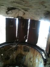
Would like to know why the handles on both sides of the window are at a different angle to those in between? Why not all look like those in between, was it to concentrate the light stroke?