Current condition
Demolished / No longer exists
Date closed / demolished
(Year is approximate.)
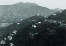
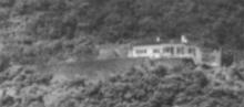
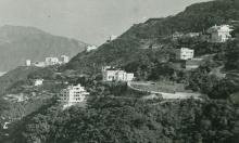
On the 1912 Peak Map its RBL 126. The house number was set in 1924 to "457, The Peak" (see 1924 map), today's address is "28, Barker Road".
The house was demolished (mid-sixties?) and replaced by Knightsbridge Court.
For some more informations see http://gwulo.com/comment/11444#comment-11444
Photos that show this Place
1938
1951
1950s
Comments
Lots vs Street Numbers
Hi Klaus,
You wrote:
On the 1912 Peak Map its RBL 126, renumbered to 457 (see 1924 map). The final address is 28, Barker Road.
A small correction - the "Lot" (piece of land) is still known as RBL 126 today: Rural Building Lot number 126. You can look up that Lot on the GeoInfo Map and see it marks the exact outline of 28, Barker Road.
The address of the buildings on that Lot has changed over the years, from "457, The Peak" to "28, Barker Road".
Regards, David
Re: Lots vs Street Numbers
Hi David,
thank you for this clarification. I didn't realize this difference, but it is clearly understandable. In Germany we have a similar system: In the land register we have cadstral sections and subsections - only ground, without mentioning houses or streets. I will correct this.
Regards, Klaus
RBL 457 sign
The RBL 457 sign (the house of Mrs. Jack Mcgregor) is still there, early 2025.