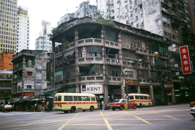
This pre-war corner building was on either the Hennessy Road or possibly that section of Johnston Road where the trams ran. I was facing south and I think that this building appears on one of my 1981 photographs - but taken from another angle. Notice how the old flat roofs were crammed with huts. Even in 1958 this was the case but the continued population growth created a huge need for these temporary homes and it would still be some years before the building of the huge housing schemes would resolve the problem - if it ever did.
Correction. I was actually facing North and the following recent contributions make the location as the Hennessy Road and Stewart Road junction
Date picture taken
1 Nov 1987
Gallery
Shows place(s)
Comments
Possible photo location
Given the wide intersection, this would probably be Hennessy Road. Probably at the junction with Tonnochy Road but facing north.
Re: Tonnochy Road
Hi there,
This would be Tonnochy Road. On the upper left there is a beige building with many windows. That would be the O.T.B. Buiilding, which still exist today.
T
Hi Moddsey
Hi Moddsey
Thanks. This has to be the same road junction and building that you and others commented on on one of my 1981 photograph - but seen from another side of the road. Andrew
1930s Junction of Hennessy and Stewart Roads
Similar pre-war tenements
Hi Moddsey
Hi Moddsey
That's a very good match. Andrew
Re: 1930s Photo
After posting it, I noted the tram tracks were not there! Something to work on.
Those blocks of old
Those blocks of old buildings erected in the 1930s were probably built to a standard design, so it's possible that this 1930s photograph could have been taken at various locations. Andrew
Pre-war Tenements
I have amended the 1930s photo for the time being until verfied to the Junction of Hennessy and Stewart Roads based on this 1941 photo . Looks like the 1930s photo was taken from a tram.
Hi Moddsey,
Hi Moddsey,
On Google Earth street view the tram tracks along that section of Hennessy road are much closer to the North side of the road, so the two black and white photographs from 1930s and 1941 could quite easily have been taken at either the Stewart or Tannochy road crossings, with the 1930s one from the top deck of a tram as you suggest. Howewver, the presence of a brand new pill box on the 1941 photograph is significant. Some years ago Rob gave me a copy of a map showing all the pill bxes, etc. Comparing that with Google Earth, the basic street pattern of the 1930s is quite clear and pill box 57 is marked as being virtually on top of the Tannochy/Hennessy road crossing. So, it's my strong belief that all those photographs, mine included, are there. If Rob sees these comments he might be able to clarify things. Best wishes Andrew
Intersection of Hennessy Road and Tonnochy Road
Dear Moddsey:
Yes, it is the intersection of Hennessy Road and Tonnochy Road (top picture). On Hennessy Road facing north. You can see the sign of the bank "集友銀行" on the right. According to page 906 of 1988 年香港年鑑, the address of the bank is 319 Hennessy Road.
1941 photo
Dear Moddsey:
That 1941 UWM photo is the junction of Hennessy and Stewart Roads. That "金門酒家" sign at the junction indicates it is Stewart Road.
By the way, it is easy to mix up the Stewart and Tonnocy junctions as they looked similar.
Details here:
https://www.uwants.com/viewthread.php?tid=6167379&page=151&nomobile=1
Re: Photo
Siimtang, Noted your comments.
If one reads through the above comments from the beginning of thread, there have been adjustments to the actual location since the first posting, which I have indicated to be the junction of Hennessy and Stewart Roads.
Pre war shop houses
I apologise for getting the exact location of this photograph wrong. My memory and statement that I was facing to the South no doubt caused some confusion, but I can now see from the contributions of Moddsey, tngan and simtang that I was actually facing North towards the harbour. The junction is also the Hennessy Road and the Stewart Road one, not the Tonnochy road one and, hopefully, I can delete the incorrect link to the now redundant pin on the map. Many thanks for your analysis. Andrew
Tonnochy Road
Hi Andrew
My interpretation of the events here is that your photo is of Tonnochy Road as identified by T and Moddsey.
Moddsey had posted a similar image (from 1930) that he initially thought was a match but which he later identified as the corner of Stewart Road thanks to the 1941 image (linked in his comment) that revealed the old pillbox and Caltex garage (oh yes, and the road sign as Simtang pointed out)
Simtang appears to have misunderstood and thought Moddsey had identified the 1941 image as Tonnochy Road, hence his comment.
I reckon that's about right - perhaps someone can confirm/deny :o)
Anyway, the upshot is that there is no need to move your marker because the original identification still stands.
Phil
Thanks Phil,
Thanks Phil,
Unfortunately I have already amended the location to Stewart Road in a footnote to my initial description and I have changed the link to the Stewart Street pin. Even so, is it still the case that my alteration to the effect that I was actually looking to the North is still correct? Athough the photograph was only taken in 1987 it was just one of several intended to simply capture some of the old buildings, with no thought that years later it would appear on Gwulo and need to be fairly accurate. I'll not 're-correct' my comments until you manage to put me on the straight and narrow! Incidentally, I'm still hoping that one day you will strike lucky and find a film clip showing the 'blowing up' of the old camp at Little Sai Wan - as I once heard had been done for a film. Maybe this comment might ring a bell with somebody else in David's large group of followers.
Regards, Andrew
facing north
Hi Andrew
yes, facing north because, as T mentioned, you can see the Overseas Trust bank building in the background - this sits on the north end of Tonnochy between Jaffe Road and Gloucester Road.
Phil
P.S I am always keeping my eye open for the film. But haven't found anything yet.
Location of the Original Photo
Yes, the location of the original photo is the junction of Hennessy and Tonnochy Roads.
I had thought the original photo was a match for the 1930s photo in the thread but was incorrect. Later revealed and adjusted to the junction of Hennessy and Stewart Roads.
Sorry for the confusion caused by adding in the 1930s photo.