Thanks. I saw on Google Earth that Smithfield is in Kennedy Town but, on Google Earth, it looked hillier than I remember and didn't look quite right. However, there are unlikely to be two Smithfields so I'll change the title on this and also on the other six photographs if you think that would be sensible. IO think that they were all taken in roughly the same area. Maybe it would be better to omit the location altogether for the others? Let me know. I shall shortly be uploading some more that I am pretty certain were taken in Wan Chai so please have a good look at them! Best wishes Andrew
For the others in the same batch, it would be very difficult to point to any district as there are no visible indicators such as the Smithfields one. Unless someone is very familiar with that particular shop or stall on the spot, it would be close to impossible to know where were you when you push the shutter back then. We could assume they are somewhere on the Island though.
Definitely the island. I think that I'll leave the others as in Wan Chai. It probablydoesn't matter very much! I'll load four more now - they are pretty certain to be in Wan Chai. I think that you or somebody else will be able to locate them. One particularly, of a corner building, has probably featured in my 1981 folder, but looks as though it was taken from a different angle.
Thank you Chai. I am not familiar with the area but do the overhead views give a precise location for the colour photograph that I took in 1987? If so, can we add an accurate pin to the map? Cheers, Andrew
interesting photo. happy to help but need some time :)
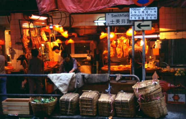
the English name "Smithfield" hasn't changed much but the Chinese name has changed a lot.
It is lovely to see the name "士美非路" on the road sign which is one of the old versions.
Over the years it changed from 士荗非路街, 是美非路 or 士美非路 to 士美菲路 (all pronounced as "si-mei-fei-lo" very similiarly to "Smithfield") "士美菲路" is the final present version.
Thank you Chai. Translating English names into Chinese characters, with the added complication of the differences betrween Cantonese / Mandarin and probably other spoken Chinese dialects and languages must always have provided problems. I admit to being completely lost on such matters! Andrew
a. camera angle is similar to photo 1 but moved slightly to right hand side to Hau Wo Street (厚和街)
b. the HSBC branch, which is on the ground floor of Nan Shan Building (南山樓), is on the top left corner at the junction of Belcher's Street / Smithfield.
Photo 3: "堅尼地城卑路乍街與士美菲路交界1979年" junction of Smithfield / Belcher's Street 1979 (uploaded by "Wah Chan")
Note to photo 3: supports the position of the HSBC branch in photo 1
Photo 4: "士美非路和卑路乍街交界處向西望" junction of Smithfield / Belcher's Street, but a little bit upper into Smithfield (by "oceandeep" on 2011/6/27 onto "WeShare" website. Not sure if it's a original post or a re-post from other websites though.)
Background: In the Chinese description, it was mentioned that a friend of the uploader gave these 3 photos(i.e. photo 4,5,6 in this post), and described as around 1960 before/after
a."旗昌洋行貨倉" (chinese name for "Shewan, Tomes & Co 's godown/warehouse" ). There are 6 little incomplete English characters (i am 70% sure, merely can read "godown" which supports the Chinese name "貨倉"). It was the past of "Smithfield Court".
b. the wall style in photo 5 can support the wall shown in photo4
c: the road slopes upwards gently.
Photo 6: along Smithfield, further south (it's also provided by the same person who provided photo 4 & 5, believed to be 1960 before/after)
The butcher shop is at the corner of 2 Hau Wo Street and Smithfield. In the 70's, may be even earlier, this part of Smithfield and whole of Hau Wo Street had been full of stalls back to back as above two SCMP getty images showed.
If not for this snapshot of daily life posted by Andrew, this street is hardly recorded anywhere. Kennedy Town used to be a grassroot district then, while Hau Wo Street is so small - it may not be covered or mentioned even in local newspapers. Except in 1978.. when above said hawker stalls were all cleared with relocation to a temporary hawkers market further up Smithfield (near today's Forbes Street MTR Exit).
The relocation was successfully completed by May 1978. In the photo, the road sign next to the "Smithfield" plate was likely related to public light buses traffic.
sources : Kung Sheung Evening News 1978-4-12 issue; Wah Kiu Yat Po 1978-5-10 issue
Smithfield may be the only few streets or roads in Hong Kong whose English name is just one single word (other e.g. Glenealy). According to Oceandeep3000 of this district in his blog, name of the butcher shop may be 三興 ('Triple Prosper').
That two-storey old building ("Tong Lau") got a classy renovation after 2000 and a children's painting studio had creatively leased the 1/F and 2/F around 2002 to 2007, preserved until it was demolished by 2008 (per Google street view of the following year).
Long-time residents of Kennedy Town, please feel free to add your valuable comments or interesting info to above.
Comments
Re: Smithfield
Hi there,
The street sign reads Smithfield, which is in Kennedy Town.
Thanks & Best Regards,
T
Hi T
Hi T
Thanks. I saw on Google Earth that Smithfield is in Kennedy Town but, on Google Earth, it looked hillier than I remember and didn't look quite right. However, there are unlikely to be two Smithfields so I'll change the title on this and also on the other six photographs if you think that would be sensible. IO think that they were all taken in roughly the same area. Maybe it would be better to omit the location altogether for the others? Let me know. I shall shortly be uploading some more that I am pretty certain were taken in Wan Chai so please have a good look at them! Best wishes Andrew
Re: other photos, probably in the same group....
Hi Andrew,
For the others in the same batch, it would be very difficult to point to any district as there are no visible indicators such as the Smithfields one. Unless someone is very familiar with that particular shop or stall on the spot, it would be close to impossible to know where were you when you push the shutter back then. We could assume they are somewhere on the Island though.
Thanks & Best Regards,
T
Hi T
Hi T
Definitely the island. I think that I'll leave the others as in Wan Chai. It probablydoesn't matter very much! I'll load four more now - they are pretty certain to be in Wan Chai. I think that you or somebody else will be able to locate them. One particularly, of a corner building, has probably featured in my 1981 folder, but looks as though it was taken from a different angle.
Best wishes Andrew
1977 Smithfield Belcher's Street junction
"A view of a traffic black spot at the junction between Belcher's Street and Smithfield Road in Kennedy Town. 09DEC77" (SCMP / Getty Images)
photo1
https://www.gettyimages.hk/detail/%E6%96%B0%E8%81%9E%E7%85%A7%E7%89%87/view-of-a-traffic-black-spot-at-the-junction-between-belchers-%E6%96%B0%E8%81%9E%E7%85%A7%E7%89%87/1096264344?adppopup=true
the chinese characters of Nanyang Commercial Bank (address: Nan Sang Buidling, 86 Belcher's Street, Kennedy Town) appeared in the photo.
photo2
https://www.gettyimages.hk/detail/%E6%96%B0%E8%81%9E%E7%85%A7%E7%89%87/view-of-a-traffic-black-spot-at-the-junction-between-belchers-%E6%96%B0%E8%81%9E%E7%85%A7%E7%89%87/1096264346?adppopup=true
photo3
https://www.gettyimages.hk/detail/%E6%96%B0%E8%81%9E%E7%85%A7%E7%89%87/view-of-a-traffic-black-spot-at-the-junction-between-belchers-%E6%96%B0%E8%81%9E%E7%85%A7%E7%89%87/1096264338?adppopup=true
photo4
https://www.gettyimages.hk/detail/%E6%96%B0%E8%81%9E%E7%85%A7%E7%89%87/an-aerial-view-of-a-traffic-black-spot-at-the-junction-between-%E6%96%B0%E8%81%9E%E7%85%A7%E7%89%87/1096264352?adppopup=true
Cheers, Chai
Thank you Chai. I am not
Thank you Chai. I am not familiar with the area but do the overhead views give a precise location for the colour photograph that I took in 1987? If so, can we add an accurate pin to the map? Cheers, Andrew
happy to help
interesting photo. happy to help but need some time :)
the English name "Smithfield" hasn't changed much but the Chinese name has changed a lot.
It is lovely to see the name "士美非路" on the road sign which is one of the old versions.
Over the years it changed from 士荗非路街, 是美非路 or 士美非路 to 士美菲路 (all pronounced as "si-mei-fei-lo" very similiarly to "Smithfield") "士美菲路" is the final present version.
Thank you Chai. Translating
Thank you Chai. Translating English names into Chinese characters, with the added complication of the differences betrween Cantonese / Mandarin and probably other spoken Chinese dialects and languages must always have provided problems. I admit to being completely lost on such matters! Andrew
My pleasure Andrew. more on Smithfield / Hau Wo Street
Hi Andrew,
Happy to help on Chinese translation. You guy's English is beautiful I am learning from all of you :)
There's a wikipedia page telling it's history including details about the changes in Chinese name. Here you go: https://en.wikipedia.org/wiki/Smithfield,_Hong_Kong
if you don't mind, I'll try to find more interesting relevant photo links as I don't really own any super old photos:
Photo 1: "The crowded hawker area at the junction of Hau Wo Street and Smithfield (Catchick Street). 13APR78" (SCMP / Getty Image)
https://www.gettyimages.hk/detail/%E6%96%B0%E8%81%9E%E7%85%A7%E7%89%87/the-crowded-hawker-area-at-the-junction-of-hau-wo-street-and-%E6%96%B0%E8%81%9E%E7%85%A7%E7%89%87/1096439592?adppopup=true
Note to photo1:
a. showing HSBC branch
b. I guess the butcher is near this junction (my good guess)
Photo 2:
https://www.gettyimages.hk/detail/%E6%96%B0%E8%81%9E%E7%85%A7%E7%89%87/the-open-market-at-the-junction-of-hau-wo-street-and-smithfield-%E6%96%B0%E8%81%9E%E7%85%A7%E7%89%87/1096439598?adppopup=true
Note to photo 2:
a. camera angle is similar to photo 1 but moved slightly to right hand side to Hau Wo Street (厚和街)
b. the HSBC branch, which is on the ground floor of Nan Shan Building (南山樓), is on the top left corner at the junction of Belcher's Street / Smithfield.
Photo 3: "堅尼地城卑路乍街與士美菲路交界1979年" junction of Smithfield / Belcher's Street 1979 (uploaded by "Wah Chan")
https://www.flickr.com/photos/wahchan/16874184325
Note to photo 3: supports the position of the HSBC branch in photo 1
Photo 4: "士美非路和卑路乍街交界處向西望" junction of Smithfield / Belcher's Street, but a little bit upper into Smithfield (by "oceandeep" on 2011/6/27 onto "WeShare" website. Not sure if it's a original post or a re-post from other websites though.)
Background: In the Chinese description, it was mentioned that a friend of the uploader gave these 3 photos(i.e. photo 4,5,6 in this post), and described as around 1960 before/after
http://www.weshare.hk/uploads/12155/JOcA89v9GLIKRyRqcYvwfA.jpg
Note to photo 4:
a. road sign of "Smithfield" is shown on the wall of "substation" ("變壓站")
b. it was described that there was flooding. Belcher's Road was being fixed.
c. at present it is the bakery shop of "Arome Bakery" (https://www.aromebakery.com.hk/Client/Portal/Index)
Photo 5: "士美非路和卑路乍街交界處向西望" junction of Smithfield / Belcher's Street, but a little bit upper into Smithfield, around 1960 after/before
http://www.weshare.hk/uploads/12155/M4HVWpXK1uczFZ_gSWzn9w.jpg
Note to photo 5:
a."旗昌洋行貨倉" (chinese name for "Shewan, Tomes & Co 's godown/warehouse" ). There are 6 little incomplete English characters (i am 70% sure, merely can read "godown" which supports the Chinese name "貨倉"). It was the past of "Smithfield Court".
b. the wall style in photo 5 can support the wall shown in photo4
c: the road slopes upwards gently.
Photo 6: along Smithfield, further south (it's also provided by the same person who provided photo 4 & 5, believed to be 1960 before/after)
http://www.weshare.hk/uploads/12155/Ap58nq_IyLT6RR1c609WNg.jpg
Note to photo 6:
evidence showing it's Smithfield? i try to guess:
a. the trees along the road quite conforms to the past roadside condition of the part near the present MTR exits.
b. the mountain behind the future Kwun Lung Lau (觀龍樓) looks like Mount Davis ?
c. the road slopes upward to the south side
(hope you find it useful. Sorry for saying too much on a single post.)
Thanks, Chai :)
Junction of Hau Wo Street and Smithfield
The butcher shop is at the corner of 2 Hau Wo Street and Smithfield. In the 70's, may be even earlier, this part of Smithfield and whole of Hau Wo Street had been full of stalls back to back as above two SCMP getty images showed.
If not for this snapshot of daily life posted by Andrew, this street is hardly recorded anywhere. Kennedy Town used to be a grassroot district then, while Hau Wo Street is so small - it may not be covered or mentioned even in local newspapers. Except in 1978.. when above said hawker stalls were all cleared with relocation to a temporary hawkers market further up Smithfield (near today's Forbes Street MTR Exit).
The relocation was successfully completed by May 1978. In the photo, the road sign next to the "Smithfield" plate was likely related to public light buses traffic.
sources : Kung Sheung Evening News 1978-4-12 issue; Wah Kiu Yat Po 1978-5-10 issue
Smithfield may be the only few streets or roads in Hong Kong whose English name is just one single word (other e.g. Glenealy). According to Oceandeep3000 of this district in his blog, name of the butcher shop may be 三興 ('Triple Prosper').
That two-storey old building ("Tong Lau") got a classy renovation after 2000 and a children's painting studio had creatively leased the 1/F and 2/F around 2002 to 2007, preserved until it was demolished by 2008 (per Google street view of the following year).
Long-time residents of Kennedy Town, please feel free to add your valuable comments or interesting info to above.