Current condition
Demolished / No longer exists
Location from Phil's blog, where he also has photos and links to more info:
http://hongkongandmacaufilmstuff.blogspot.hk/2014/12/the-amsterdam-kill…
Photos that show this Place
1960
1961
1974
Comments
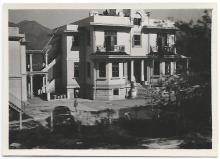
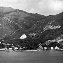
Ho Tung Lau
TaiHangWong writes:
In the aerial photo on Page 118 of "Hong Kong in Old Times" there was a large piece of rectangular land runing south to north lying to the east of the railway tracks and Tai Po Road on the shoreline off the Wo Liu Hang Village at Fo Tan further south of the spit of land of Lok Lo Ha. Its size seems to match the description of Ho Tung Lau on Page 98 of "The Cultural Relic and Heritage of Shatin" published by the Shatin District Council in 2005. This book said that " Sir Ho Tung possessed over 20,000 sq feet of land near the shoreline of the current Fo Tan Railway Station on which he built a three-storey villa."
With the help a magnifying lens I found this piece of rectangular land has the following features : 1. In the northern end there are two large buildings. The one on the extreme north is smaller than the one next to it further south. The latter appears to be the main building of the HO Tung Lau villa. The relative position and size of these two buildings match those of the two buildings shown in the Robert Mitchum's movie in one of the links you mentioned. 2. In the centre there appears to be two tennis courts in an inverted L shape ( with the shorter " - "side at the top and pointing to the left ). 3. To the west and the south of the tennis courts is a large lawn. 4. In the southern extreme there is another building which apperas to be the living quarter of the domestic helpers.
Shatin Army camp
It looks as though Ho Tung Lau was used by the army/RAF at some point - I can't remember which thread we were discussing the other buildings on, but Hugh has a page about it over on his website: http://industrialhistoryhk.org/shatin-airfield-2
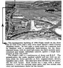
Also used as the
Also used as the "headquarters building of RAF Flight 1900 in Shatin", see:
http://gwulo.com/comment/35529#comment-35529