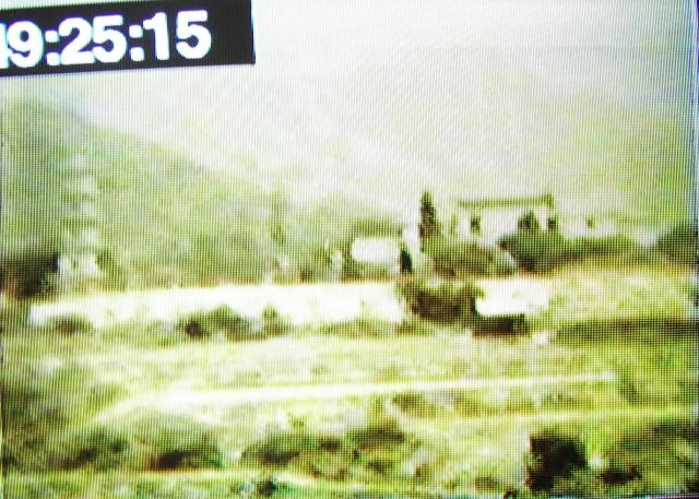
This is another "still" taken from an old 8mm film made in 1948.
It shows a pagoda, on a flattish terrain, it could be near the Kowloon hospital as the film shows the hospital shortly before. Or maybe somewhere in the New Territories?
Suziepie
Date picture taken
25 Feb 1948
Shows place(s)
Comments
Pagodos are us!
The original question on this thread was “Where is this pagoda?”
The film clip images appear to show a pagoda with multiple levels with very large hills/mountains very close behind it.
The assumption appears to be that this is the pagoda at Tsui Shing Lau/Ping Shan as pagodas are rare in Hong Kong, despite it not having a similar number of levels to that in the screen-shot.
Local village hearsay from various sources claim that at some time in the past, but with no certainty as to actually when, it did have more levels, up to seven have been quoted
However it has yet to be explained how the pagoda in the 1948 screen-shot if at Ping Shan somehow reverts to just the three levels shown in the photograph of the Ping Shan radar unit dated around 1950. Ands no one seems to notice or documents the reduction in height at this time period?
I do not believe the screen-shot in question was taken in Hong Kong unless someone can come up with an image of an alternative pagoda in Hong Kong in a similar environment and background.
In 1948 it would have been quite easy to cross the border into China to take such a film clip, especially if the person shooting the film was acting in an official capacity or as a liaison officer dealing with those on the other side. By October 1949 the border was effectively closed.
Doctor Solomon Bard, the eminent historian in his book “In Search of the Past-A Guide To The Antiquities of Hong Kong” has a brief section on the Ping Shan pagoda saying:-
The Pagoda is thought of as a characteristically Chinese building; it achieved its greatest development as the marker of a sacred Buddhist relic or as a place of Buddhist devotion.
There is a paucity of pagodas in Hong Kong compared with the Main1and, where splendid tall pagodas are a common enough feature of the view. Among the few, Tsui Shing Lau is the sole authentically ancient pagoda.
It stands in Ping Shan in the heart of the Tang clan district. Though small and modest by any standard, it enjoys a special and honoured place in local tradition, which sets the date of its building in the 14th century, early in the Ming dynasty. Local people relate that it was built as a protection against “unfavourable influences from the North”. Its location in alignment with Castle Peak mountain was later interpreted as being propitious for scholarship and distinction. The Tang clan of Ping Shan claims, with historical truth, that among its members have flourished a number of distinguished scholars and high officials.
The Pagoda is a six-sided structure, about 10m wide and 20m high, built of Chinese grey brick. Granite blocks frame its entrance. The intricately arranged brick corbels separating the three storeys form a pleasing architectural feature. Of a graceful and dignified aspect, the Pagoda is nonetheless simple in style with little embellishment.
It is said to have been originally seven storeys high and subsequently to have lost the four upper storeys in two separate incidents, presumably caused by the violence of typhoons; a geomancer had then advised the villagers to let the Pagoda remain at three storeys.
Its name of Tsui Shing Lau, which is carved on one of the tablets decorating the Pagoda, may be translated as the “building of many stars”. Two other stone tablets claim for it a heavenly connection, and within is an altar with wooden deities; nonetheless, the Pagoda is neither temple nor Buddhist shrine, but principally a fung shui structure “
It’s strange that there appears to be no photographs/ paintings/drawings or mention of a large pagoda in the New Territories similar to the film clip for any period except the much more recent Shatin pagoda on the hillside. Such a multi-story pagoda would be a magnet for any pre-war/post-war tourists to visit and picture, but no images appear to exist. Even those found for the Tsui Shing Lau pagoda all appear to be post-war including the black and white images.
In 1945 the Royal Air Force decided that Kai Tak airport was “too dangerous” to function as a military airfield, and as an aside even as a civil airport for modern post-war aircraft due to the close proximity of the surrounding mountains An immediate decision was made to build a new airport in the New Territories at the Ping Shan area as it was flat with no mountains to cause a threat to aircraft..
The RAF’s Airfield Construction Units descended on Ping Shan to prepare the ground for an airport using thousands of local workers. The book “Airfield Construction Service 1936-46” has a chapter of their time in Hong Kong.
While prepared to clear whole villages, graves, hills and rivers there is no mention in this book or in the many official documents and newsprint reports I have seen is there any mention a “tall pagoda” being in the way of the airport site or being an impediment to flying aircraft.
The RAF’s effect on the area must have been massive at the time.
To partially quote from the book:-
“A preliminary survey was made for the proposed joint civil and military airfield project at Ping Shan, some 20 miles away from the city in the New Territories. The proposed site for a new airport to replace the badly sited Kai Tak had been selected from maps, and Squadron Leader Ronald MacKintosh was to be responsible for the survey. A very gallant elderly gentleman, recently released from a prisoner-of-war camp, drove the team around the New Territories. They were able to report favourably on this site, subject to more detailed examination. The four members of this party were the first Europeans to penetrate into the Ping Shan area since the Japanese occupation. Some 7.5 square miles was surveyed in an area where life had hardly changed for a dynasty. The site seemed ideal, with both approaches over the sea. The valley was fairly level, but with hills on either side, including Castle Peak west of the southern approach. A number of small villages and homesteads would have to be re-located elsewhere, but more importantly for the local people, it would involve the cutting down and removal of several hills which were the burial grounds of ancestors from the villages.
Cutting across vast areas of paddy fields, the runway was planned to be 1,800 metres (5900 feet) long and 45 metres (150 feet) wide, beginning from Nai Wui village and ending about 280 metres (920 feet) beyond Shek Po towards Deep Bay, passing through Sun Fung Wui, Chung Uk Tsuen, Tin Sum and Li Uk Tsuen. It was planned to be extendable by another 800 metres (2,600 feet) and double the width at a later date.
Further site exploration was more encouraging, and on the basis of preliminary reports Air Ministry approval was given for construction work to proceed. One month later the quarrying flight set to work on a hill of granite; they commenced on digging out a new channel into which to divert the river. The first construction squadron was moved from Kowloon to a tented camp on one side of the valley and, as might be expected, villagers became much alarmed as to what future lay in store for them. Initial preparation completed, access roads and a connecting light railway were built to the quarry which produced 15,000 tons of broken granite monthly.
Many high-ranking officers visited the site, including the C-in-C, Lord Mountbatten. On 27 October 1945 Air Chief Marshal Sir Keith Park and Admiral Sir Cecil Harcourt visited Ping Shan and for them a special rock blast at the quarry was laid on.
The road between Tsun Wan and Tai Mo Shan Peak was rebuilt by the Wing to take heavier motor traffic and the clearing of the hill outcrop at Taiwashan in the Ping Shan valley meant the removal of 230,000 tons of rock.
Work went on apace at Ping Shan until March 1946, when work had to stop!
New international standards had been agreed governing the design of international airports, and Ping Shan did not satisfy these regulations, the southern approach being too narrow. The RAF could have used it, but Air Ministry was not prepared to go it alone. This was a great relief for the local people, who had objected most vehemently because so much of the rice paddy would have been lost.”
More can be found on the Ping Shan airport saga relating to the villagers in one of the chapters in the pdf below that has been highlighted previously on Gwulo.
http://www.galaxylink.com.hk/~john/paul/manuscripts/16.pdf
There is also a UK Imperial War Museum documentary film featuring the Ping Shan airport construction site but no signs in it of any tall pagodas.
HK Public Records Office
Interesting extract as follows:-
Extract from the HK PRO record - re Tiger Balm Garden pagoda
Image for 365-1-38/c042-1_t.jpg
Part of text - “The white pagoda has seven storeys, conforming to the Chinese belief that the number of storeys should be odd.”
Date August 1959
For you TNgan
TNgan - Is it just me or could anyone estimate
What is the distance between the Pagoda and the hills behind?
Between 1.2 and 2 miles. Source Google ruler.
1. Is it just one hill, or, a hill in front with a ridge going way back?
Yes and multiple ridges. You can see these from the village carpark just a few yards away from the Tsui Sing Lau pagoda.
Are they connected?
Yes, but looked at from the pagoda, or Exit A of Tin Shui Wai West Rail Station, they blend in with each other. In the present poor weather conditions with pollution haze, the ridge lines merge with each other.
It also depends on the angle and elevation from which they are viewed.
You can see them from Google Earth, or by taking the West Rail to Siu Hong, but keep your eyes peeled – the train is rather swift.
2. Why do I have the feeling just by looking at the screen shot that the pagoda is very close to the hills?
Perception, depth of view.
Remember you are only looking at one frame.
We have yet to see the DVD run which may well put everything into a better perspective.
3. How high are the hills/ridge behind the pagoda? About 15 metres up to 271 metres. Google Earth referenced. No idea how accurate this is.
We are unable to see the full skyline in the screen shot......
Yes, we also cannot see the top (apex) of the pagoda either. I think this is due to strong sunlight on the day and the angle of the sun at the time. Remember that the picture started from 8mm film which has been converted to video film. It is now being converted again to DVD format. There will be loss of resolution with each conversion.
4. What about the elevation angle from the lens toward the top of the pagoda and beyond?
As before, the apex of the pagoda is not visible. Measure your own eye height above the ground and you will have your first measurement. The distance of the photographer from the pagoda is something I am trying to work out by triangulation. I have a few more ideas but more study is required.
*********** What is important is the type of camera lens and its magnification and focal length. This we don’t know, but it would answer some of your questions above.
During the day of Christmas Eve I collected two sets of contour drawings and the enlarged aerial photograph of the pagoda from the Survey and Mapping Office, Yuen Long. With regard to the latter, the greatest of luck has arrived because it shows the hexagon shaped stone pedestrian level fence/wall around the base of the pagoda which is still there today. When I have a moment I will visit and measure all sides of this hexagon wall and from that I can calculate a ball park measurement that will offer something for the height of the pagoda.This will be the first "true" measurement obtained in the current day.Updated mathematics to follow.
The other items are contour maps – to scale – of the hills that interest you. After I have put these through an A1 scanner and saved them in TIFF format, I can then import them into AutoCAD. After that I shall trace out the contour lines. Thereafter I can identify the contours to show the ridge lines. Tracing contours my way is doing it the hard way. It can be done via Google Earth and converting the data through different software programmes and then dumping it into AutoCAD.
More comparisons between Tsui Sing Lau and Funghuang pagodas
I hope the JPEG's are good enough to view clearly. Remarkable small differences in detail concerning the eave tiles (round green shaped) and the drip-off tiles at two corbel levels on each pagoda. I wonder why there is a difference? Different builder? Someone dared to copy another architects structure? Highly dangerous 4-600 years ago! Damage repair. Dimensional differences of materials?
More measurements and enlarged photograph
Sunday morning 28th December 2014.
Visited the Tsui Sing Lau pagoda and took my file with me. The purpose was to measure the hexagonal shaped stone pedestrian wall which surrounds the pagoda. This can be seen on the enlarged photograph shown below.
The longest side measures 173.25 inches which is about 4.4 metres. By using a protractor to walk off the wall top measure measurement against the shadow and the approximate centre of the pagoda the length over the ground is around 50.53 feet.
Knowing the Latitude and Longitude of the pagoda from Google Earth, I then used a US Navy calculator to work out the azimuth and elevation of the sun on the 2nd June 1949. Hong Kong Summertime (GMT +9) was also factored in. For the purposes of local time I selected Noon (12.00hrs) and then made successive calculations for each hour of the afternoon.
The known data was then put through TANRADIAN using Excel and produced the following heights based on each hour:-
Noon 139.66 feet 42.57 metres
13.00hrs 75.80 23.10
14.00hrs 46.48 14.17
15.00hrs 28.08 8.56
16.00hrs 14.26 4.35
17.00hrs 2.61 0.80
What I don’t know is the time the photograph was taken.
Whilst doing all this work a rather interested crowd gathered including two Russian tourists. One man, a local resident on his way to work, was adamant that the pagoda had seven levels. As he was in a hurry he said he would copy the information he has and would leave it with the security guard in due course. I need to follow up.
Would any local Hong Kong resident like to borrow my aerial photographs and various known dimensions and conduct his own set of calculations?
David, please note that the enlarged photograph has Lands Department copyright protection. If they find it and jump up and down I may need to ask you to remove it in due course.
The next event on the calendar is to wait for the 2nd June 2015 and see where the shadow falls for the hours mentioned above.
It is tempting to note that the calculation at 14.00hrs is awfully close to the Heritage Trail booklet mention of approximately 13 metres, and 17 metres I have seen on a Survey and Mapping Office document.
Re: The shape/outline of the shadow......
Hi there,
I wonder if we could trying to figure it out by the shape and outline of the shadow........
Thanks & Best Regards,
T
TNgan,
TNgan,
You’re right. Using the best optical accessories I can find to offset my descent into hereditary blindness, I rotated the photograph and looked again. In the photograph below you will see three arrows pointing to bulges. All those interested in this topic will instantly know what these mean. The photograph is dated 2nd June 1949 so the picture ties in exactly with IDJ’s lengthy note above concerning the saga of RAF Ping Shan.
In the space of 105 forum topic notes by interested people, this matter has been through the washing machine and tumbled around. The outcome has been marvellous, with all sorts of views and opinions. I regret and apologise for my less than welcome remarks which are due an excess of fresh bread with cheese, and my favourite wine. My comments are, fortunately, not from the heart. They derive from sheer interest, zeal, and intense curiosity.
The wheel has more-or-less fully turned and I am beginning to think that the Tsui Sing Lau was indeed built with seven layers, but four of these went before the invention of the camera to record “true” film records. I use the word true in inverted commas because I have a wild thought that cine film could be used to take a picture of an artist’s painting. But why would an artist paint a boring landscape with a pagoda on the left hand side? Surely and artist would want to paint the magnificence of the structure?
We are back to square one – “Where is it?”
Until we can see Suzipie’s cine film as a YouTube run, and then verify that any one scene was taken in Hong Kong, we don’t know where it is.
THE SAGA OF THE PAGODA
Dear Dave and TNgan and IDJ and all
It would seem logical therefore, following on from the above disclosures, that this is perhaps the last photo/film taken of the pagoda befoe it lost its top 3-4 levels. The RAF B/W photo is dated June 1949. My film image is in the week of 14 February 1948 - so that means the top levels were removed during those 14 months. Obviously it lost its top before the RAF came along.
I am still convinced that this is the Tsui Sing Lau pagoda - because the distant hill, the far distant mountains, the trees and buildings to the right - and the terrain all "fit the picture" - unless someone can come up with another pagoda in the vicinity with all these contributing factors, which I believe would be far too big a coincidence.. If another such big pagoda existed in this area we would all know about it!
Other points:
- Ron Brooks, the camerman, (my Dad) was certainly not galivanting around China - this film footage was taken at the time of the birth of his son (my little brother) at the Kowloon hospital, while he was visiting the Hospital in the week of 14 February 1948. He was an officer at the HK Fire Brigade and was not "acting in an official capacity with liaison or any other Govt work over the border" as has been implied - for a start it was not his "portfolio". He was simply filling in time between visits to his wife and new born son.
- It has been mentioned that traditionally the pagodas were 5, 7 or 9 levels - odd numbers being good luck - yet the Funghuang pagoda in Shenzhen has 6 levels - which is contrary to that statement.
- Within the same 5 minute footage that includes the pagoda Ron Brooks also "shot" the Kowloon Hospital, my baby brother, my molther, the Yaumati Theatre, a train crossing the New Territories, boys on buffalos, an Atlas plane with passengers taking off from an airfield - and a building with the Union Jack flying, that looks like it is somewhere on the border, so all these have to be in the same vicinity - ie: a few miles radius of the Kowloon Hospital.
Thanks for your efforts,
Suziepie
The enigmas must have soloutions
Suziepie,
Please don’t go away just yet.
I did ask in an earlier post if the sequence of scenes in the film could be briefly described from start to finish with a short explanatory sentence i.e Yaumati theatre.
Like this:-
Scene 1 …………..
Scene 2 ……………
Scene 3 ………….
Scene 4………
Scene 5 ………….
The reason for asking is to try and follow the photographer’s movements. If this precise sequence detail can be made available Google Earth can be used to paint the picture of movements.
I am interested to ascertain if the scenes follow what was, in my day (late 1960’s early 1970’s), called a “Round Robin” trip around the New Territories and back to the start point in Kowloon.
I have already started work on the “border crossing” structure and have entered most of the Sino British border police and international crossing posts with identifiers on my Google Earth. Likewise the Ping Shan pagoda of 1949.
In the next week or so I shall also visit the Kowloon Canton Railway Museum at Tai Po and see what ancient photographs have been hung on the wall. This may be a lucky (probably unlucky) short cut into finding the ridgeline behind your train scene.
Have you ever considered writing to the current day Director of Fire Services to enquire if you father’s service record is still available? If it is, you might like to add in the nature of your enquiry and, in particular, try and find out where he was posted in 1948. The nature of his duties would be a bonus.
The address is here:-
Mr. LAI Man Hin, FSDSM
Director of Fire Services,
Fire Services HQ Building,
1 Hong Chong Road,
Tsim Sha Tsui East,
Kowloon,
Hong Kong.
Pagodas do not vanish from the earth very easily.
It is interesting to know that your father was a fire officer. His knowledge of Hong Kong would have been extensive, and he would also have had access to many places which may have been out of bounds to the public.
An overlooked clue perhaps
Hong Kong has been eliminated as the location for the pagoda shot on Suziepie's film.
I missed the following and I think it gives a hint to look in a different direction.
"this 'still' frame is from the same 8mm film and was taken just prior to the footage of the pagoda, if not the same day then probably the same week in 1948.
This "still" frame concerns the "border post" which has an uncertain location. The next frame is the not in Hong Kong pagoda. Perhaps the photographer could see it from the border fence (without crossing the fence) and it was located on what we call the mainland side.
If the cine camera was a good one with several lenses including a telephoto (Bell & Howell type for example), then it would have been easy to take an unobstructed shot.
I have a montage of three images in colour taken from the Lok Ma Chau lookout in 1970 or 1971. I will dig them out and post them later.
Any thoughts?
Where is the Pagoda?
Hi all -
Okay - its not the Tsui Sing Lau - and I have learnt a lot about pagodas and Ping Shan!
I list here the sequence of Roland's tour - starting from the Kowloon Hospital on week of 14 February 1948 (I will also upload a few more "still" frames of this sequence to correspond with the list below - you can follow how close they are to each other by the running time sequence on top left corner of each frame):
1. Kowloon Hospital
2. Atlas plane at Kai Tak airport
3. Panorama of coastal settlement and sea
4. Panorama of same settlement with distant mountains
5. Train crossing presumably heading for Kowloon
6. A small Chinese stone bridge in fields
7. A Chinese town with several covered trucks
8. Same town with more trucks
9. Chinese women carrying baskets and crossing bridge
10. Presumably a border crossing with flag, hut, barricade
11. Same area with barricade
12. Presumably a border crossing building with high fencing and Union Jack
13. Operation of a pump in channal in Chinese town
14. Same area showing street with bridge over the channel
15. Terrain on right of pagoda showing a stone arch and thatched roof
16. The Pagoda with buildings on right and hill behind and distant mountains
17. Boys on buffalo
18. Houses in hillside near sea
19. Sampans
20 Coast with junk
That is the end of the sequence and the end of Roland's "round robin". Some photos showing these scenes are already uploaded - you can find them by the running time schedule on left corner - and others I will add now.
Suziepie
screen captures
Hi Suzie - is there any chance of you uploading the pictures for 5, 18 and 19?
Regarding the border crossing, there are several now including Lo Wu, LokMa Chau, Man Kam To and Sha Tau Kok. Sha Tau kok seems too far away to be included on your dad's trip but I wonder if Man Kam To was a border control point in 1948? Of course, it could be the the 'assumed' border control point on your video is in fact simply the guarded entrace to one of the large barracks in the area. Most were guarded by a small hut and barrier.
1937 Tsui Shing Lau Pagoda
Some 1937 photos of Hong Kong are being sold on eBay. One is of the pagoda at Ping Shan as shown here If the date of the photo is corrrect, then this is the earliest pre-WWII photo of the pagoda that I have seen showing its 3 levels.
TSUI SING LAU PAGODA
Thank you Moddsey for this link.
I have looked at it and find that it is the same (almost) photo as the one located by David B and linked to the site on Wed 2014-12-10:
Quote: ......I've searched for pagoda in Images at the Public Library's MMIS. There are a few shots of Tsui Sing Lau pagoda, but the earliest is dated "ca. 1950s": https://mmis.hkpl.gov.hk/coverpage/-/coverpage/view?_coverpage_WAR_mmisp...
This is a HK Museum of History photo that they label as: ‘Date created/published ca 1950s’. Nowhere does it say the photo is dated in the 1930s.
The author in eBay needs to be careful of false advertising and fraudulent sales if he/she cannot verify that the photo was definitely taken in 1936 - your link was here
If you compare the eBay photo with the HK Museum photo (almost same) you will see they were taken at the same or almost same date. On the roof of the pagoda a shrub is growing. It is in both photos and it is identical - there would be a big difference in the shrub within two years either way! Plus the surrounding bushes are the same.
BTW - I am still not yet convinced that ‘my’ pagoda is not the Tsui Sing Lau Pagoda in Ping Shan as I cannot see any logical explanation for me to believe otherwise: the Feb 1948 film was ALL taken within this region of the NT; the HK Museum of History itself says the pagoda is ‘the only surviving ancient pagoda in HK.’; the surrounding terrain is sympathetic; the basic structure is of the same design -
Considering:
Thus all that being correct it obviously means the top levels were removed during those 14 months.
I have found there was a typhoon on 28 July 1948 - about 5 months after the film was made in Feb 1948, which could have caused the lost ‘top’ - see below:
THE COURIER-MAIL - (BRISBANE, QLD. AUSTRALIA) - 29 July 1948 - Page 1
HONG KONG HAVOC: 20 DEAD - July 1948
HONG KONG, July 28 ( A.A.P.-Reuters) . — At least 20 people are known to have lost their lives last night when a typhoon hit the city and surrounding area. A much higher casualty list is feared when full details are known. Large numbers are missing and many homeless. Several houses collapsed under the combined force of the wind and torrential rain, burying an undetermined number of Chinese occupants.
Many junks and sampans were sunk, and a number of small steamers were washed ashore in Hong Kong Harbour. The British India Company's 10,000 ton ship Sangola broke away from a buoy, but the anchor held. A 90ft landslide has cut the Kowloon-Canton railway, and services are dislocated. A tidal wave is reported to have struck Cheung Chow Island 20 miles east of Hong Kong sinking about 50 boats of all types.
The typhoon was originally expected to pass 150 miles to the east. But it suddenly switched direction yesterday and headed for the colony. The city was hurriedly battened down, thousands rushed for home by the ferries, while small craft sought shelter.
Suziepie
Ebay link-Ping Shan pagoda
If you scroll right down on the ebay link/posting it will show the offered image is part of a picture album dated 1937 owned by someone who appears to have spent time in Hong Kong.
"A page of the album is shown with other images as are details of the original owner. From an album collection of Hong Kong postcards (and photographs) taken by Mr. L. Thorne in 1937/38 - a very candid, personal and professional view of life in and around Hong Kong and the New Territories"
Another Ebay Link - Ping Shan Pagoda
Another photo from the 1937 album collection of L. Thorne as seen here
even without these 1937
even without these 1937 pictures, it was fairly obvious to me (and others after talking to them) that the pagoda on the film is not the Tsui Sing Lau pagoda.
TSUI SING LAU PAGODA
Sorry Phil and IDJ to remain stubborn but until someone can tell/show me where in the same vicinity (on the 'round-robin' route in the Northern New Territories) this pagoda is/was then I have no choice but to remain adamant that it HAS to be the Tsui Sing Lau pagoda. The film footage I have does not, cannot, lie. (Sooner or later I will put it on the site).
And as I have said previously - the postcard is NOT dated and is too similar to the 1950s image used by the Museum. It could very easily have been slipped into the album at a later date. I have done the same thing with albums inherited from my own father. The album referred to above was sold at an auction by auctioneers who had acquired it, not by the author of it, so who can really verify where and when that postcard originated. .
Suziepie
Postcard
It looks set to forever remain a mystery...
Re: Another Place, Another Time
Hi There,
I managed to locate the mentioned concrete base back in November 2015. The coordinate is approximately 22.512028, 114.121452 in Google Maps.
I was unable to determine how old it is though.
T
Re: Another Place, Another Time
Hello tngan
I cannot find where this - concrete base - was mentioned, or the relevance of it?
Kind regards,
Suziepie
Re: Another place, another time,
Hi Suzie,
It is only a reply to IDJ's message concerning the piece of story he quoted from a book, talking a demolished pagoda. Litterally speaking it is sort of off topic.
The concrete base (if you click on the Google Map link embedded in my previous message), is a white\grey dot among the trees on the upper left.
T
It looks set to forever remain a mystery...
"It looks set to forever remain a mystery..."
Turns out I was wrong because the issue of the identification has finally been resolved (albeit 10 years later).
It was a property near Tuen Mun called Lei Yuen. I've created a place for it here: https://gwulo.com/node/60140
to go with T's archway here: https://gwulo.com/node/50184
Suziepie, did you ever manage to get the film in a higher definition?