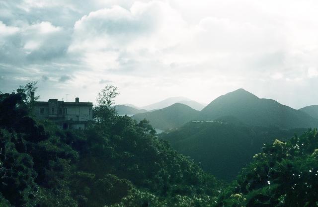
The Hill in the far right should be Nam Long Shan with Lamma Island at the back. The photographer was likely somewhere along the slopes of Middle Gap/Aberdeen Reservoir area. We could try to identify the house by the left though. It's one of those either on Middle Gap Road or Mount Cameron Road.
Not only are they houses half way below, but I think I see detached houses on sizable lots at the bottom of the hill. It is difficult to be sure, but if those indeed are mansions, I think that makes Shouson Hill more likely.
I don't think that many houses so far below would be visible from Mount Cameron / Middle Gap
After gazing at Google Map with Tarrain enabled, I believe the photographer was likely closer to Wong Nei Chung Gap, Maybe the house was one of those along Blacks Link. Have to go up there and take a look to confrim.
Doug's photo is one of an interesting series that he took across the Deep Water Bay Valley. I guess he took them on the same day. This. I believe, is the one taken from the furthest point north, at Wong Nei Chung Gap Road just after it crosses the Gap and is about to descend towards Aberdeen.Going south along Repulse Bay Road from here, others in the set are at;
Returning to this photo. Tree cover prevents a similar pic being taken from the same spot today, but a similar, higher, viewpoint can be obtained from the Wong Nei Chung Reservoir dam wall.
Brick Hill from Wong Nei Chung Gap, by gw
The white house on the left in both photos is at No.4 Repulse Bay Road. Previously the house here was called Holmesdale (www.gwulo.com/node/13911), but I don't know if todays building is the same or has been rebuilt.
If that house was indeed #4 Repulse Bay Road, it was the resident of a General Practitioner (Doctor) in the 1960s whose name is Shiu. His clinic used to be at the present day C.C. Wu Building in Wanchai. I know because Dr Shiu was my doctor when I was a kid. His clinic was big with is own X-Ray machine at the back room.
A note, the elevation of the new and old photo is a bit different. I remember there are foot paths below Wong Nei Chung Gap. Maybe the old photo was taken down there. We might not be able to do that today as the slopes are much overgrown now.
Looks like a match. Thanks for the effort, gw. The present house was constructed in 1987.
tngan, I didn't find a directory entry for No. 4 Repulse Bay and Dr. Shiu from the 1960s. When I was searching for the address of the Hongkong Telephone Company's old house (No. 37), I found that quite a few houses in Repulse Bay were owned by doctors in the 1950s and early-1960s.
Oh well, I had been told about Dr Shiu's (uncertain if that's the correct spelling) address back then. Maybe he rented it or something else. The good doctor was long gone so there is no way to check with him anymore.
Hello, tngan. Even though I didn't find him in the directory, I think there is still a good chance Dr. Shiu was resident at the address at some point. The Hong Kong $ Directories I often check for old addresses covered mainly foreigners that were in the civil service and major companies.
If Dr. Shiu retired (and possibly immigrated) in the 1980s, he may well have sold the property to the owner that redeveloped in '87. The current house was then sold again in '97.
Comments
Re: The hill should be Nam Long Shan
Hi there,
The Hill in the far right should be Nam Long Shan with Lamma Island at the back. The photographer was likely somewhere along the slopes of Middle Gap/Aberdeen Reservoir area. We could try to identify the house by the left though. It's one of those either on Middle Gap Road or Mount Cameron Road.
My 2 cents,
T
Re: Development half way below the peak
Hi there,
The image is not clear enough for me to identify anything. The other thing is that I may be too young to know that area at that time.
There is still an estate called Manly Villa up the slopes, but it doesn't seem to match. Maybe that was something on Shouson Hill instead?
My 2 cents,
T
Shouson Hill
Not only are they houses half way below, but I think I see detached houses on sizable lots at the bottom of the hill. It is difficult to be sure, but if those indeed are mansions, I think that makes Shouson Hill more likely.
I don't think that many houses so far below would be visible from Mount Cameron / Middle Gap
Re: On 2nd thought, more likely closer to Wong Nei Chung Gap
Hi there,
After gazing at Google Map with Tarrain enabled, I believe the photographer was likely closer to Wong Nei Chung Gap, Maybe the house was one of those along Blacks Link. Have to go up there and take a look to confrim.
Thanks & Best Regards,
T
No.4 Repulse Bay Road
Doug's photo is one of an interesting series that he took across the Deep Water Bay Valley. I guess he took them on the same day. This. I believe, is the one taken from the furthest point north, at Wong Nei Chung Gap Road just after it crosses the Gap and is about to descend towards Aberdeen.Going south along Repulse Bay Road from here, others in the set are at;
www.gwulo.com/atom/15396
www.gwulo.com/atom/15397
www.gwulo.com/atom/15398
www.gwulo.com/atom/15405
www.gwulo.com/atom/15403
www.gwulo.com/atom/15400
On reaching the coast (assuming he walked downhill) he seems to have visited both Deep Water and Repulse Bays, taking www.gwulo.com/atom/15401 and www.gwulo.com/atom/15402 .
Returning to this photo. Tree cover prevents a similar pic being taken from the same spot today, but a similar, higher, viewpoint can be obtained from the Wong Nei Chung Reservoir dam wall.
The white house on the left in both photos is at No.4 Repulse Bay Road. Previously the house here was called Holmesdale (www.gwulo.com/node/13911), but I don't know if todays building is the same or has been rebuilt.
#4 Repulse Bay Road
Hi there,
If that house was indeed #4 Repulse Bay Road, it was the resident of a General Practitioner (Doctor) in the 1960s whose name is Shiu. His clinic used to be at the present day C.C. Wu Building in Wanchai. I know because Dr Shiu was my doctor when I was a kid. His clinic was big with is own X-Ray machine at the back room.
A note, the elevation of the new and old photo is a bit different. I remember there are foot paths below Wong Nei Chung Gap. Maybe the old photo was taken down there. We might not be able to do that today as the slopes are much overgrown now.
T
No. 4 Repulse Bay
Looks like a match. Thanks for the effort, gw. The present house was constructed in 1987.
tngan, I didn't find a directory entry for No. 4 Repulse Bay and Dr. Shiu from the 1960s. When I was searching for the address of the Hongkong Telephone Company's old house (No. 37), I found that quite a few houses in Repulse Bay were owned by doctors in the 1950s and early-1960s.
Re: #4 Repulse Bay
Hi there,
Oh well, I had been told about Dr Shiu's (uncertain if that's the correct spelling) address back then. Maybe he rented it or something else. The good doctor was long gone so there is no way to check with him anymore.
Thanks & Best Regards,
T
Dr Shiu
Hello, tngan. Even though I didn't find him in the directory, I think there is still a good chance Dr. Shiu was resident at the address at some point. The Hong Kong $ Directories I often check for old addresses covered mainly foreigners that were in the civil service and major companies.
If Dr. Shiu retired (and possibly immigrated) in the 1980s, he may well have sold the property to the owner that redeveloped in '87. The current house was then sold again in '97.
#4 Repulse Bay Road and the Ho's
Hi there,
That area seemed to be owned by the Ho's these days. #1 & #4 of Repulse Bay Road, and some more blocks in Black's Link.
Thanks & Best Regards,
T