I was walking around the headland that forms the north side of Waterfall Bay recently and noticed an old metal structure partly submerged in the sea.
Unidentified structure. Lamma Island in distance., by gw
Can anyone please tell me what it is?
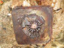
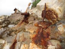
It's about 100m north of Pillbox No.6 and consists of three levels which I'll call upper, middle and lower. The upper level sits just above the high water mark and is a row of metal poles embedded in concrete running parallel to the water.
Part of the upper level., by gw
They're all heavily rusted, but someone has made the effort to protect some of them from further erosion by covering them with plastic bottles, bags and tape. I presume whoever did so knows what they are and believes them to be worth preserving. Thirteen metal poles remain, with a space denoting where a fourteenth probably once stood. Some of them have square shaped metal plates and, or, white piping attached.
Upper level, 3rd pole from north. Wah Fu Estate (left) & Lamma Island (right) in background., by gw
Upper level, looking down on 3rd pole from north., by gw
Upper level, 4th pole from north., by gw
Upper level, 7th (left) & 8th poles from north., by gw
Upper level, 9th to 12th poles from north, all with white protective piping., by gw
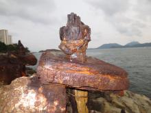
The middle level is about three meters below the upper and set in a shallow excavation in the rock. Fourteen metal poles, or the remains of them, can be seen running parallel to the upper level. Being within the tidal zone the poles here are more rusted and consist of only plain metal poles without attachments.
Middle level, 1st (left) to 3rd poles from north., by gw
Middle level, 12th (left) & 13th poles from north., by gw
The lower level is submerged much of the time. Even at low water most of it remains out of sight beneath the water. It lies about 5m beneath, and parallel to, the middle level.
Lower level., by gw
Lower level, by gw
From what can be seen above water, it appears to consist of a frame of metal beams supporting circular pipes each containing a metal rod or cable.
Part of lower level showing frame supporting circular pipe containing rod or cable., by gw
Part of lower level showing two circular pipes each with a rod/cable within. "U" shaped frame rear and center., by gw
Today only thirteen circular pipes remain, but I suspect there were originally fourteen and that their rods/cables connected to the fourteen poles of the middle and upper levels above.
I don't know what the structure is, but two possibilities come to mind.
Or could it be the anchor point for strings of naval mines laid to protect Hong Kong prior to the Second World War? The website www.indicatorloops.com/hongkong.htm contains information on Hong Kong's minefields and tells us there were two types. Firstly, "contact" mines, designed to explode on physical contact with enemy shipping. Secondly, "controlled" mines, detonated by electric impulse sent along cables to the mines from land based observers. In association with the "controlled" minefields, "indicator loops" were laid on the seabed in the approaches to Hong Kong. These detected vessels crossing over them and sent an electric signal along a cable to alert watchers ashore who could decide whether to detonate the "controlled" mines.
The website contains a map showing the positions of minefields. One string of "contact" mines and two strings of "controlled" mines are shown crossing the East Lamma Channel, i.e. the channel between Hong Kong and Lamma Islands onto which the unidentified structure faces, but only the "contact" mine string is shown coming ashore in the vicinity of Waterfall Bay. However, I don't know if the map positions these minefields exactly or just provides a general guide.
I emailed Dr. Richard Walding, the author of the "indicator loops" website, to ask if the unidentified structure could have been part of Hong Kong's mine defences. He replied that it is not part of an "indicator loop" , but may be part of a "controlled" minefield or the anchor point for a sea boom, a physical barrier to shipping. Unfortunately, I wrote to Dr. Walden before I'd found the lower level of the unidentified structure (it was submerged and invisible on my first visit) and he's been out of touch since I sent him photos of the lower level, so I don't know if they would cause him to change his opinion.
I've viewed arial photos from 1949, 1963, 1983 and 1997 of the headland on which the structure is built, but couldn't see it nor any associated structure.
Grateful if anyone can please enlighten me as to what this structure is?
Comments
Unidentified Structure on Waterfall Bay Headland
I was walking around the headland that forms the north side of Waterfall Bay recently and noticed an old metal structure partly submerged in the sea.
Can anyone please tell me what it is?
It's about 100m north of Pillbox No.6 and consists of three levels which I'll call upper, middle and lower. The upper level sits just above the high water mark and is a row of metal poles embedded in concrete running parallel to the water.
They're all heavily rusted, but someone has made the effort to protect some of them from further erosion by covering them with plastic bottles, bags and tape. I presume whoever did so knows what they are and believes them to be worth preserving. Thirteen metal poles remain, with a space denoting where a fourteenth probably once stood. Some of them have square shaped metal plates and, or, white piping attached.
The middle level is about three meters below the upper and set in a shallow excavation in the rock. Fourteen metal poles, or the remains of them, can be seen running parallel to the upper level. Being within the tidal zone the poles here are more rusted and consist of only plain metal poles without attachments.
The lower level is submerged much of the time. Even at low water most of it remains out of sight beneath the water. It lies about 5m beneath, and parallel to, the middle level.
From what can be seen above water, it appears to consist of a frame of metal beams supporting circular pipes each containing a metal rod or cable.
Today only thirteen circular pipes remain, but I suspect there were originally fourteen and that their rods/cables connected to the fourteen poles of the middle and upper levels above.
I don't know what the structure is, but two possibilities come to mind.
Could it be the remains of power cables taking electricity from Hong Kong Island to Lamma? The first such cables were laid in 1962 ( www.industrialhistoryhk.org/lamma-island-industry/ ).
Or could it be the anchor point for strings of naval mines laid to protect Hong Kong prior to the Second World War? The website www.indicatorloops.com/hongkong.htm contains information on Hong Kong's minefields and tells us there were two types. Firstly, "contact" mines, designed to explode on physical contact with enemy shipping. Secondly, "controlled" mines, detonated by electric impulse sent along cables to the mines from land based observers. In association with the "controlled" minefields, "indicator loops" were laid on the seabed in the approaches to Hong Kong. These detected vessels crossing over them and sent an electric signal along a cable to alert watchers ashore who could decide whether to detonate the "controlled" mines.
The website contains a map showing the positions of minefields. One string of "contact" mines and two strings of "controlled" mines are shown crossing the East Lamma Channel, i.e. the channel between Hong Kong and Lamma Islands onto which the unidentified structure faces, but only the "contact" mine string is shown coming ashore in the vicinity of Waterfall Bay. However, I don't know if the map positions these minefields exactly or just provides a general guide.
I emailed Dr. Richard Walding, the author of the "indicator loops" website, to ask if the unidentified structure could have been part of Hong Kong's mine defences. He replied that it is not part of an "indicator loop" , but may be part of a "controlled" minefield or the anchor point for a sea boom, a physical barrier to shipping. Unfortunately, I wrote to Dr. Walden before I'd found the lower level of the unidentified structure (it was submerged and invisible on my first visit) and he's been out of touch since I sent him photos of the lower level, so I don't know if they would cause him to change his opinion.
I've viewed arial photos from 1949, 1963, 1983 and 1997 of the headland on which the structure is built, but couldn't see it nor any associated structure.
Grateful if anyone can please enlighten me as to what this structure is?
The "cables to Lamma" idea
The "cables to Lamma" idea looks possible. From the satellite view above, this looks to be the section of HK Island coastline closest to Lamma.
Another possibility could be the remnants of a pier for one of the two ropeways in operation around here: http://gwulo.com/node/9502
Regards, David