Current condition
Ruin
Date completed
I looks like it is reached by a set of stairs and path next to 20 Broadwood Road, or take the road up to Broadwood Park, 38 Broadwood Road.
Chinese name is Coffee Garden Cemetery - 咖啡園墳場
Use http://www.map.gov.hk to see it properly.

Forgotten Souls: A Social History of the Hong Kong Cemetery
By Patricia Lim
When in 1844 rice growing in Happy Valley and So Kon Po Valley were forbidden, the thirty-seven acres of land in that valley had been purchased by the government, drained and divided into five farm lots. At the land auction in 1846, Duddell bought one lot and by 1857 had acquired all five lots and is said to have established a coffee farm on the land.
Photos that show this Place
2011
2011
2011
Comments
coffee garden cemetery
I stumbled on this several years ago. You can walk up from the right hand side of the stadium, through the abandoned foundations and floors of squatter settlements long since cleared. Chinese graves are visible through the overgrown vegetation near the top, as are several wild dogs... It's not the easiest of going given the wild nature and broken staircases of the place, plus I couldn't find any obvious exit on to Broadwood Road and was forced to scale a wall and drop down on to the carpark of a high-end development. Despite my disshevelled appearance no one seemed stopped me though having a white face may have helped...
The whole area was part of the So Kon Po resettlement area, so-called by the government, as detailed here: https://gwulo.com/node/5076
Re: coffee garden cemetery
Hi 80sKid, wow, this must have been quite an adventure. Did you take any photos in the cemetery? I was told by the same internet forum member that there is an entrance beside the Jardine's Lookout Garden Mansion.
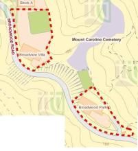
Mount Caroline Cemetery
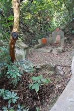
Mount Caroline Cemetery is situated just below what was The Towers at 20 Broadwood Road, now demolished, but final home of my grandfather Charles Warren (1872-1923). A tender exists from the architects A. C. Little & C. E. Warren in 1913 to buy Crown land in order to build an access road to the cemetery for funeral processions. Little and Warren must have gone into partnership to build the road. My cousin, Diana Warren (b. 1927), who lived at 19 Broadwood Road until 1938, has memories of exploring the cemetery as a child. You can get to it via a small path up a bank from Broadwood Road above the existing no. 20. The steep overgrown cemetery represents a piece of old Hong Kong that remains intact next to the new tower blocks with their sentries. Above it is an immaculate tennis court that may be on the site of the old Towers tennis court. My attempt to find the site of The Towers and discovery of the cemetery was in November 2004. It sounds easier to attack it from the top!
Jill, do you and Sean Olson
Jill, do you and Sean Olson have a common great-grandfather, John Olson ?
John Olson
Hi Anneliec,
John Olson was my great grandfather and also the great grandfather of Jill Fell. John 1 - there are three and I am the third - had children with two Chinese women that we know of.
If you look at the chapter Graves at Happy Valley in www.thehongkonglegacy.com all is explained.
Sean
<!--StartFragment-->
Absolutely, but only in 2004 did I search for and find the birth certificate of my grandmother, Hannah Warren née Olson, courtesy of the HKPRO, revealing that Sean and I had different Chinese great-grandmothers, as he reports. John Olson (John 1) had sons by each of them, both of whom he named John. The first, by Yau Kum Olson, and who died aged 2 months in 1879, would have been brother to my grandmother and so my great-uncle; the second, by Ching Ah Fung, later Ellen Olson, was Sean’s grandfather.
There are 2 enterances to the
There are 2 entrances to the Cemetary. From the bottom, behind the stadium: N 22° 16.313 E 114° 11.345 or from the top, near the top of Broadwood Road: N 22° 16.128 E 114° 11.352
You can also see the path on Openstreetmap. Its a fascinating place, but during the summer months it can be a bit stifling with a lot of mozzies. Bring plenty of spray.
TB
caroline hill
yep, it's a relatively well maintained path/staircase, easiest to start from the top and end up by the stadium. I think my jungle trek must have taken in some other more isolated graves
I am fascinated by it too,
I am fascinated by it too, having heard so many haunted story when I was young.
Didn't know it still exsists until last year and visited it thrice.
The author in fact is the wife of a masonic brother of mine.
The author I meant the author
The author I meant the author of ''Lost Souls HK Cemetery", Ms P LIM.
Mt Caroline Cemetery
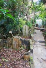
I did some exploring this weekend, and ended up in a small clearing that had a stone carved with "Mt Caroline Cemetery", but it was not where the maps show the Cemetery to be. I have posted all the pictures on my blog:
http://www.rossmoore.net/2014/01/an-awfully-big-adventure.html
We also followed a path down through what was the So Kon Po settlement area (I think) almost to the stadium.
re: mt caroline cemetery
Good find with the cemetery marker
Yep that's the old resettlement area, see more here: https://gwulo.com/node/5076
Re: fruit tree in the album
Hi Sarah,
That is not a Durian tree. According to the shape of the fruit I believe it is Jack Fruit. These are being grown locally and is quite common.
Thanks & Best Regards,
T
re: Mount Caroline cemetery
Hu Liyuan , a thinker and writer who had a strong influence on Republic of China founder Sun Yat-sen is buried there. Anyone know the origin of the name for the hill?
http://www.scmp.com/article/591929/finding-historic-tomb-spurs-call-better-care
re: Mount Caroline cemetery
Hi Sarah, Thanks for taking plenty of photos.
The two square stones you found were used to mark the edges (usually the corners) of a plot of land's boundary.
The first one (see photo) would have been one of several that marked the boundary of the cemetery.
The second one (see photo) originally read "W^D No.13", and was one of at least 13 stones that marked the boundary of a piece of land belonging to the War Department, ie the British Army. I didn't know that the Army had land around here. I wonder what it was used for?
If possible, please could you mark the location of the stones on your map?
Regards,David
PS Here are some more of these boundary stones around Hong Kong: https://gwulo.com/hong-kong-war-department-boundary-stones
re: mt caroline cemetery
the cemetery was gazetted in January 1867, to replace the Chinese cemetery in Happy Valley (guessing that was the one on the plot that later became Le Calvaire convent). The graveyard was for Chinese dying "east of the Parade Ground." Read somewhere that Japanese burials took place there towards the 1940s.
http://sunzi1.lib.hku.hk/hkgro/view/g1867/710837.pdf
"Caroline"
The name "Caroline Hill" is in use by 1863 (See Plate 2-2 in Mapping Hong Kong).
On the 1845 map, the name Caroline Hill isn't used, though there's a building there marked "Morgans Bung". Perhaps a connection between Morgan (or a later resident of that building) and Caroline?
Regards, David
re: Captain Morgan
seems we already have a place for Morgan's bungalow. https://gwulo.com/node/8223
Captain Morgan died in Macau in 1843 and is buried in the Protestant cemetery there. His wife was with him when he was living on Caroline Hill. He was also made a Justice of Peace.
See details here: http://books.google.com.hk/books?id=flbXWNoVraEC&lpg=PA201&dq=Captain%2…
re: coffee plantation
this book appears to describe the cemetery at the old coffee plantation as the city's main one, in 1911: (also has some great descriptions of the span and development of the city at that time)
http://books.google.com.hk/books?id=2CQI31592qIC&lpg=PA106&dq=%22jardine's%20corner%22&pg=PA106#v=onepage&q=coffee&f=false
Is this the same person
Is this the same person mentioned in the article you (80sKid) quoted?
https://zh.wikipedia.org/wiki/%E8%83%A1%E7%A6%AE%E5%9E%A3
Anyone has the idea of the location (with coordinates) of the marker WD13?
I have only been to the #2 boundary stone of this cemetery a few times, but haven't come across the other markers at all.
Has the name Caroline having
Did the name of this hill, Caroline, having anything to do with this battleship?
https://www.nationalhistoricships.org.uk/register/430/hms-caroline