Google Translate is a bit off the mark in this case. I checked with my wife and she says it translates something like:
觀 : goon1 : view
龍 : lung6 : dragon (Google translated this phonetically to 'long')
角 : gok3: a geographical feature that is a pointed piece of land, so a point / promontary / corner in English.
So the phrase translates to something like:
The corner where you get a view of the dragon.
I've no idea what the dragon refers to though. If it was a corner you turned and got the first view of Kowloon / Nine Dragons, that could be an explanation, but is Kowloon visible at this point, or still hidden behind the hill?
My speculation is, it might have something to do Fung Shui. I have been told whenever a Fung Shui Master's investigation, they would use the term of 'observing the Veins of the Dragons', see how they come and go, something like that. The Brits (especially those of the various Hongs) are known to believe in Fung Shui in general........
Or, the Jardine Taipan back than might have asked someone knowledgeable for a Chinese Name of the site, which does not have anything to do with its English name at all.
Yes, a Fung Shui dragon is another possibility. Or just "Give me a Chinese name that sounds auspicious"!
I wonder if features in this area had local names before the arrival of the British? It was quite a remote and uninhabited area, so may not have been given names by the earlier inhabitants.
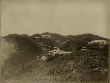
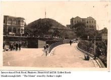
Para.124(c) of the 1924 PWD Report talks about progress in the construction of Stubbs Road, now called Peak Road, from Magazine Gap to Victoria Gap and mentions that the "Mount Kellett Road Bridge was completed". Since I can't think of any other bridge it could be, I presume it refers to the single lane bridge that still exists today across Peak Road joining Mt. Kellett and Plunkett Roads.
I think the bridge is also referred to in "Resist to the End", the diary of Charles Barman covering the Battle of HK and his subsequent internment. On 11th December 1941, in the midst of the Battle, Barman was driving an army vehicle from Magazine Gap to the Mount Austin Battery when it was spotted by two Japanese planes.
"Within a few seconds, the planes commenced strafing me along the highway to the Peak where there is no cover whatsoever for about one and a half miles. All I could do was to zigzag the car along the road to avoid the bullets that were being sprayed at me from right to left of the road and in front of the vehicle. How lucky I was to be able to reach safety under a small overhead bridge where I sheltered for about fifteen minutes until the planes withdrew at which time I continued my journey to Mount Austin".
Although Barman doesn't specifically state that the bridge in question was at Jardine's Corner, I can't think of any other it could have been.
Comments
The Chinese translates as
The Chinese translates as "view of Long Point". Was there a "Long Point"?
Google Translate is a bit off
Google Translate is a bit off the mark in this case. I checked with my wife and she says it translates something like:
So the phrase translates to something like:
The corner where you get a view of the dragon.
I've no idea what the dragon refers to though. If it was a corner you turned and got the first view of Kowloon / Nine Dragons, that could be an explanation, but is Kowloon visible at this point, or still hidden behind the hill?
Any better explanations welcome!
Regards, David
Re: 觀龍角
Hi there,
My speculation is, it might have something to do Fung Shui. I have been told whenever a Fung Shui Master's investigation, they would use the term of 'observing the Veins of the Dragons', see how they come and go, something like that. The Brits (especially those of the various Hongs) are known to believe in Fung Shui in general........
Or, the Jardine Taipan back than might have asked someone knowledgeable for a Chinese Name of the site, which does not have anything to do with its English name at all.
My 2 cents,
T
Dragons
Hi Thomas,
Yes, a Fung Shui dragon is another possibility. Or just "Give me a Chinese name that sounds auspicious"!
I wonder if features in this area had local names before the arrival of the British? It was quite a remote and uninhabited area, so may not have been given names by the earlier inhabitants.
Regards, David
"Mount Kellett Road Bridge"
Para.124(c) of the 1924 PWD Report talks about progress in the construction of Stubbs Road, now called Peak Road, from Magazine Gap to Victoria Gap and mentions that the "Mount Kellett Road Bridge was completed". Since I can't think of any other bridge it could be, I presume it refers to the single lane bridge that still exists today across Peak Road joining Mt. Kellett and Plunkett Roads.
I think the bridge is also referred to in "Resist to the End", the diary of Charles Barman covering the Battle of HK and his subsequent internment. On 11th December 1941, in the midst of the Battle, Barman was driving an army vehicle from Magazine Gap to the Mount Austin Battery when it was spotted by two Japanese planes.
"Within a few seconds, the planes commenced strafing me along the highway to the Peak where there is no cover whatsoever for about one and a half miles. All I could do was to zigzag the car along the road to avoid the bullets that were being sprayed at me from right to left of the road and in front of the vehicle. How lucky I was to be able to reach safety under a small overhead bridge where I sheltered for about fifteen minutes until the planes withdrew at which time I continued my journey to Mount Austin".
Although Barman doesn't specifically state that the bridge in question was at Jardine's Corner, I can't think of any other it could have been.