Page 134 of “Mapping Hong Kong” shows an 1876 map of the sea defences at Lyemun Pass, today’s Lei Yue Mun Channel, at the eastern entrance to Hong Kong Harbour.
Four dotted lines cross the Pass from the headland that today houses the Museum of Coastal Defence to the south coast of the Devil Peak peninsula opposite. The outer dotted line, labeled “Small Torpedoes”, starts from Pak Sha Wan, at the eastern tip of the headland. The three inner dotted lines are marked “Buoyant Electro-contact Torpedoes”. One runs from just to the west of Pak Sha Wan, the second from roughly the middle of the headlands’ coastline, and the third from the approximate position of the Brennan Torpedo Cave at the Coastal Defence Museum. However, as the Brennan Cave was constructed much later, from 1892 to 94, the inner line may not denote its position.
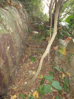
I recently scrambled along this length of coastline to see if any traces of the ancient torpedo defences remain today. When dry the route along the rocks isn’t particularly difficult, and is made much easier by numerous rope handrails (only one of which broke under my weight!), improvised ladders, the ubiquitous concrete blob footholds and even a rickety wooden bridge.
Starting at the eastern end of the headland, next to Heng Fa Chuen, is the small bay of Pak Sha Wan above which the artillery battery bearing its name still stands.

I couldn’t see anything that might once have been part of the “Small Torpedo” installation marked on the old map.
Moving westwards, a few hundred meters along the coastline, brings you to the first significant man-made structures, just a concrete block in-front of a low brick wall.

I’ve no idea what function these once served, but it’s difficult to imagine them as part of a torpedo system. Nevertheless, they’re good markers for locating the first item of real interest, hidden from sight in the bushes a few meters to the right of the three massive boulders in the top right of the photo. The same boulders also appear in http://gwulo.com/node/17112 with the Pak Sha Wan Battery above.
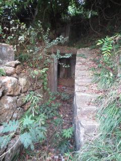
You have to be almost on top of it to see a stone-wall lined path leading inland. Some of the rocks have fallen in and it’s a bit overgrown, but passable.
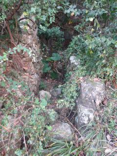
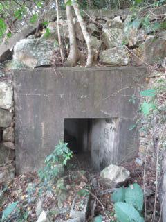
The path leads to the entrance of a concrete bunker with stones and earth piled on the roof, presumably for camouflage and protection.
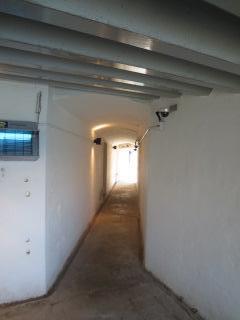
A corridor leads away from the entrance. It’s remarkably dry and free of mozzies and other unfriendly wildlife.
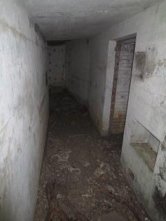
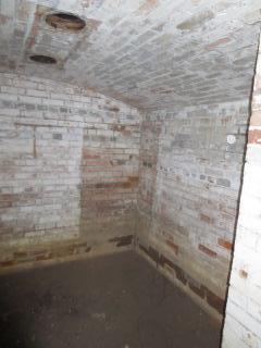
On the right of the corridor is a windowless room, entirely brick lined, with a slightly arched roof and two round ventilation holes.
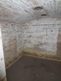
The same room from another angle.
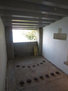
Back into the corridor. It runs a few meters further then ends in a room with a large aperture looking over the Lye Yue Mun Channel, if the view wasn’t blocked by undergrowth.

The roof is corrugated and slopes slightly down towards the front.
It looks like it’s made of concrete, but shows rust marks, so perhaps there’s metal above the concrete or concrete was poured onto a layer of metal that has rusted away.

The lower sill of the front aperture has two “V” shaped indentations, and the side wall curves inwards where it meets the sill.

The far wall contains an indentation in the shape of a flattened, inverted “T”, which is just visible in the photo below. I wonder why it was constructed in this shape?
There’s only one way in and out, so it’s back along the corridor to the exit.
Outside, concrete steps lead up the hill, but after only a few meters become too overgrown to follow.
So what is this building and when was it constructed? A visit to The Museum of Coastal Defence provided some of the answers.
The Museum occupies the western end of the Lyemun Headland and houses a number of old artillery batteries designed to prevent enemy ships entering Hong KongHarbour. One of these is the Lye Yue Mun Pass Battery. It’s been restored and is open to visitors. It’s very similar to the unidentified building. Firstly location. They’re both on the waters edge. Secondly structure. They’re both concrete bunkers. Both also have only one entry/exit and a central corridor.
Off the corridor is a familiar looking windowless, brick-lined, room with a slightly arched roof and two round ventilation holes.

At both ends of the central corridor are rooms (one more than in the unidentified building) with corrugated ceilings sloping towards frontal apertures. One has a shelf-like indentation in the wall shaped like a flattened, inverted letter “T”.
Based on the strong similarities between the Lye Yue Mun Pass Battery and the unidentified building it seems safe to conclude they must have been constructed at around the same time and for the same purpose.
According to information displayed at the Museum, the Lye Yue Mun Pass Battery was completed in March 1892 and armed with two quick-firing (QF) 6 pounder guns intended to stop small, high-speed, torpedo-carrying destroyers entering the Harbour. “The Guns & Gunners of Hong Kong” says that construction was carried out between 1890 and 1892. A plan of the structure labels the brick lined inner room as a magazine. So the unidentified building was probably also constructed around 1890 to 1892 as a QF Battery with the internal, brick lined, room used as a magazine.
Back to “The Guns & Gunners of Hong Kong”, Page 190 of which has a map of the batteries on the Lyemun Headland. The map is undated but, as it doesn’t show Pak Sha Wan Battery (constructed 1901-1903), it’s probably pre-1903. The most easterly battery marked on the map is the Reverse Battery, with three gun emplacements well back from the water. A path runs down from the Reverse Battery to the shore. Although no building is marked, “QF Gun” is written in very faint lettering, just about visible with a magnifying glass, where the path reaches the water. Just like the Lyemun Pass Battery, the unidentified battery housed a Quick Firing Gun.
Page 194 of “Guns & Gunners of Hong Kong” states that Lyemun Reverse Battery was built in 1886-7 for three 9 inch guns, but by 1894-5 an additional 6 pound QF gun had been added. Therefore the old battery building was probably constructed between 1886-7 and 1894-5 to house a 6 pounder Quick Firing Gun. This date range fits nicely with the Lyemun Pass Battery’s construction date of 1890-1892.
Now back to the walk. A few hundred meters to the west of the old battery building a number of concrete beams and debris litter the rocks.

I couldn’t see any sign of a foundation for a building, but obviously one once stood in the close vicinity.
Further along the rocks a square concrete block stands on a concrete base. Again, I’ve got no idea what it was for.

To the west the cliffs get steeper, necessitating the path to run through the undergrowth above the rocks at times. Eventually an old wooden ladder takes you up to a narrow, concrete path that ends on the flat roof of another military structure. This one’s constructed entirely of concrete and basically consists of two rooms, one on top of the other in a sort of ground floor and basement arrangement, joined by an external staircase.
I’ll start on the top floor. This is a single room with a rounded, or perhaps “V”, shaped front facing the water and a square rear dug into the earth behind. A single, wide, aperture runs around the whole length of the front wall. Over the years the inside of the room has been filled with earth to the level of the sill of the aperture.

Another shot taken from inside the room shows the entrance.

Moving further around, a cupboard sized structure stands between the entrance and the back wall.

A view of the rear wall completes the internal tour.

The top floor viewed from its eastern side.

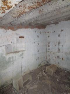
Badly damaged steps descend from the first floor to the entrance to the basement.
A short corridor, partly blocked by earth, leads into the basement.

Lots of soil has flowed into the basement through its only window.

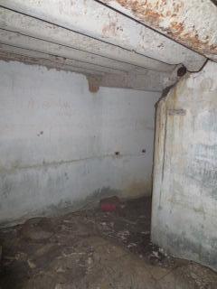
Looking back out of the basement a cupboard sized alcove is seen on the left of the exit.

What purpose was this building constructed for and when? I’ve not come across anything exactly the same as it elsewhere and haven’t been able to find any information on it. Its presence on a stretch of coast long used by the military, and built entirely of concrete, means it too must be of military origin.
The wide, curved or V-shaped, aperture on the top floor bears some resemblance to bunkers built elsewhere to house searchlights. However, this building is bigger than a Lyon Light shelter, but smaller than the searchlight bunkers at Jubilee and Chung Hom Kok Batteries.
According to “Guns & Gunners of Hong Kong” the need for searchlights to support artillery at Lyemun was noted as early as 1886, and by 1889 at least one searchlight had been installed although its exact location is not mentioned. Based on the curved/V-shaped aperture I think this building is probably a searchlight shelter, but I’m open to better suggestions.
Moving on, within a few meters there’s a temple.

Next to the Temple is another military bunker.

The view from the opposite direction.

Whilst the temple is obviously unrelated to military matters, I suspect it may be a recent redevelopment. It would have been illogical for the Army to allow a temple to be sited with a (suspected) artillery searchlight on one side and a bunker on the other.
The bunker itself is badly damaged with huge cracks in its walls and roof.


Looking through the front aperture reveals a large hole in the roof. Lots of earth has fallen in over the years, almost filling the bunker.

Again I don’t know what function this bunker originally served. It’s not a pillbox as the front aperture is too big. I didn’t notice at the time, but looking at the above photo now, I’m wondering if the ceiling at the back of the bunker is corrugated as seen at the Lyemun Pass and Reverse QF Batteries? If so, it may help to date this bunker to the same era, i.e. the late 1800’s or early 1900’s. Anyone know what it is and when it was built?
From the temple and bunker it’s a short distance to the Museum of Coastal Defence, the perimeter railings of which can be seen in the next photo.
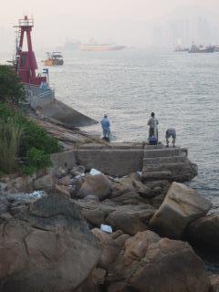
In between, is a concrete platform jutting out into the water on which the three men are fishing. I didn’t go closer and don’t know what this is either. Can anyone help?
That was it for the day. Although I didn’t find any structures related to the torpedo defences marked on the 1876 map, there were plenty of other items of interest. “The Guns of Gunners of Hong Kong” (Pages 46) suggests that the Lyemun Headland wasn’t used as an artillery site until proposed by the Royal Commission on Defences in 1883. Whilst that doesn’t preclude the Headland being used for torpedo defences prior to that date, it would seem illogical not to supplement the torpedos with artillery. For this reason I now suspect the 1876 map may have been a plan of proposed works rather than a map of existing ones.
re: Structures on the South Coast of Lei Yue Mun Channel
That was a good outing!
I note that Wikipedia says "In the 19th century, mines were called torpedoes", so I guess the lines of “Buoyant Electro-contact Torpedoes” on the 1876 map show what we'd call mines today.
So, not likely to be much sign of them remaining, but a good excuse for a scramble, and lots of other interesting stuff to see.
Good detective work identifying the Lyemun Reverse Battery. We've got a Place for that at: https://gwulo.com/node/11016. I recommend you use that Place to identify your photos of the battery. You're currently using "Lei Yue Mun - Lyemoon Pass", which refers to the water-way. Sorry to be picky!
I don't recognise the building with the curved/V-shaped aperture either. I wonder if Rob knows what it was?
I wonder if the concrete platform in your last photo is the pier described in recent wartime diary entries by A H Potts:
Corpl. O’Connor who was in charge asked me to ring up GHQ and report that a great many sampans had crossed from Shaukiwan to Devils Peak and that they should be prevented from returning as it was more than likely they would have Japanese aboard disguised as fisherfolk.
I reported this, also that I thought it might be advisable to blow up the pier at the foot of the road, and was informed these matters were being attended to; however, the sampans returned, and I have no doubt contained many Japanese and ammunition, and the pier was not destroyed.
When we reached the magazines Corpl. O’Connor met me in a very nervous state; he told me they had been subjected to a terrific shelling all day, which had only just stopped and that all the guards had cleared off. He also said the pier had not been blown up and that the light across Lyemun was still out of order.
re Structures on the South Coast of Lei Yue Mun Channel
David,
Ha, and there I was looking for caves or cuttings in the rocks where torpedoes (using the modern meaning of the word) could be launched from, when I should have been looking for something completely different! The old definition certainly explains why I didn't find what I was searching for. Thanks.
I've included the Lyemun Reverse & Pass Batteries as "places".
GW
A series of Defence Electric
A series of Defence Electric Lights (DEL) - searchlights - were installed along the HK Island side of Lye Yue Mun. A single one on the point at Pak Sha Wan was installed in a Matshed building around 1890. This was superceded by five concrete housings along the coastline, completed in April 1902. They were numbered 1 to 5, 1 and 2 facing East into what was then called Lyemun Bay, now Heng Fa Chuen. The other three faced northwards across the water of the pass.
A review not long after they were completed reduced the number to four: 1 and 2 remained unchanged, a new No. 3 was built on top of the old No. 3, No.4 old was abandoned, and a new No. 4 was built on the site of the old No. 5. This was completed in May 1910.
Today, No.1 and 2 no longer exist, lost to reclamation for Heng Fa Chuen, No. 3 old/new and old No.4 remain, as does the base of old 5/new 4.
To follow GW's path, the two storey building is No. 3, the yellow structure near the temple is old No. 4, and the concrete base near the torpedo launch ramp is old 5/new 4.
As suggested, the domed building at the beginning is probably the 6pdr QF Gun position of the original Lyemun Reverse Battery.
Re: Brennan Torpedo Station
Hi GW,
Are you suggesting other than the one (the cave with the torpedo model) in the Museum, there might be another Brennan Torpedo Station somewhere over there?
Thanks & Best Regards,
T
Brennan Torpedo Station
Rob,
Thanks for your informative post.
T,
Based on the old map I thought there may have been some other torpedo related works there, but David's post explains why I couldn't find any.
GW
Military path of the QF gun bunker
We visited the site last year after reading your post and successfully cleared the vegetation blocking our way. After making a left turn passed the corner, we saw a pretty much wide open path heading straight toward the Pak Sha Wan Battery direction. There is a relatively spacious Japanese cave (around 3m deep) on the left side of the wall midway through the path. Then we ran into a dead end, which is the brick wall of the Pak Sha Wan Battery. I believe this was supposed to be the old military path connecting the PSW battery to the QF gun position as early as 1900s.