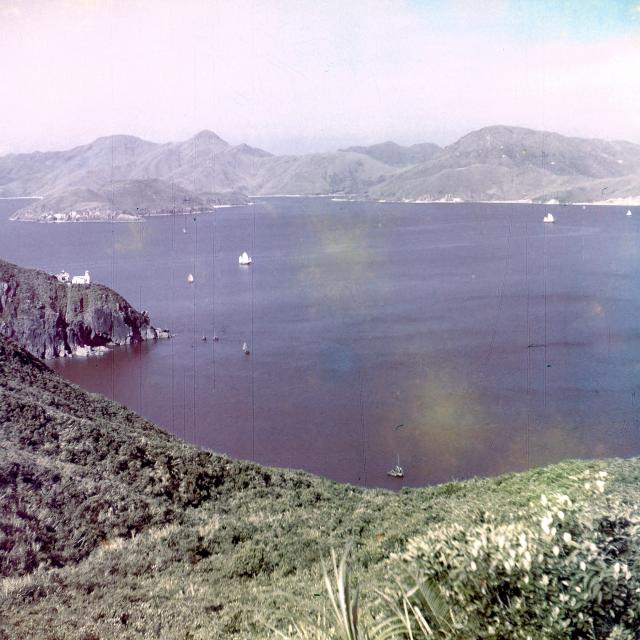
I remember that the lighthouse is Hak Kok Tau Lighthouse (Cape Collinson Lighthouse) [黑角頭燈塔]. The upper side of the Lighthouse is FAT TONG CHAU (JUNK ISLAND) [佛堂洲] . Well, the upper position of JUNK ISLAND is a sharp peak that is TIU YUE YUNG (HIGH JUNK PEAK) [釣魚翁]. The left top seashore side is PAK SHING KOK [百勝角]. Therefore, the sea must be JUNK BAY (TSEUNG KWAN O).
In my opinion, This place is in Cape Collinson Road [歌連臣角道] nearby Siu Sai Wan East [小西灣以東].
Thank you for your attention.Best Wishes and a Happy Mid-Autumn Festival.
Comments
Is This Hebe Haven ?
Don't think so, Mike. But your pic does look like its taken somewhere along the CWB Road.
The building on the headland in your photo has a quite distinctive conical-shaped tower which may provide a clue to identifying the place.
Could it be looking across Silverstrand Bay towards Ngau Mei Chau (Shelter Island) the headland being Ngam Tau Sha ?
I remember Run Run Shaw in those days had studios at CWB and built some remarkable outdoor film sets there !
This is how Hebe Haven looked in 1963 - there were even more boats moored there before Typhoon Wanda in late 1962.
Is this Hebe Haven?
I wonder if it could be Cape Collinson light, which I have read was substantially altered on 1966,but I am not certain about the topography.
re; Cape Collinson
Certainly looks right from the shape of the hill in modern photo below; so in the background would be where all the reclamation and landfill are on the western side of Clearwater Bay
http://imgcdn.geocaching.com/cache/large/7f4c8fdd-fe8c-478c-b9e1-2cbe0a56b3dd.jpg
If we flip the photo the
If we flip the photo the coastline looks very much alike with morden photo below the lighthouse.
Photo Position: (Cape Collinson Road / Siu Sai Wan East)
Dear Everybody:
I remember that the lighthouse is Hak Kok Tau Lighthouse (Cape Collinson Lighthouse) [黑角頭燈塔]. The upper side of the Lighthouse is FAT TONG CHAU (JUNK ISLAND) [佛堂洲] . Well, the upper position of JUNK ISLAND is a sharp peak that is TIU YUE YUNG (HIGH JUNK PEAK) [釣魚翁]. The left top seashore side is PAK SHING KOK [百勝角]. Therefore, the sea must be JUNK BAY (TSEUNG KWAN O).
In my opinion, This place is in Cape Collinson Road [歌連臣角道] nearby Siu Sai Wan East [小西灣以東].
Thank you for your attention.Best Wishes and a Happy Mid-Autumn Festival.
USER: kitsonkwang2012 EDIT DATE: 28ANG2015 V_(;->)_V
Thanks for all the comments.
Thanks for all the comments. I've flipped the photo horizontally, and also updated the title from "Is This Hebe Haven?".