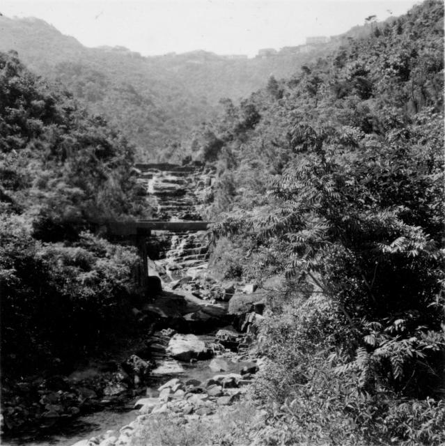
I think I know this bridge. It is very likely the one next to the catch water, quite close to the main dam of the Upper Aberdeen reservoir. But the current location is overgrown with trees and scrubs, very difficult to crash through from above. I'll take a picture of it and compare the stream and see if they look similar the next time I walk by.
It's good to know that some of these places that my husband took photos of so long ago are still there and that you can recognise them. I hadn't noticed the bridge before as we only had the small prints and It doesn't show up very well on there but I can see what you mean now that I can zoom in!
I believe I could confirm the approximate location of the bridge in Google Maps. If you key in the coordinates of 22.25903 & 114.16169 you would be within 25m radius of it. The stream and the catch water are clearly visible in Google Maps.
I have taken a few photos of it, but the old photo appeared to be taken on the other side of the catch water. A few decades back there used to be a foot path on the other side. The angle where I stood wasn't right.
Today, it had been overgrown. I couldn't even see the stream behind the bridge. But if I step back about 50 metres, I was able to see the skyline behind it. They look more or less the same as the old photo.
Thank you T for visiting this place and for the photos, I never thought anyone would identify this but you have obviously done so and I am very grateful.
Comments
Re: Victoria to Aberdeen 1954
Hi there,
I think I know this bridge. It is very likely the one next to the catch water, quite close to the main dam of the Upper Aberdeen reservoir. But the current location is overgrown with trees and scrubs, very difficult to crash through from above. I'll take a picture of it and compare the stream and see if they look similar the next time I walk by.
Best Regards,
T
Thanks T, It's good to
Thanks T,
It's good to know that some of these places that my husband took photos of so long ago are still there and that you can recognise them. I hadn't noticed the bridge before as we only had the small prints and It doesn't show up very well on there but I can see what you mean now that I can zoom in!
Best regards, Pauline.
Re: Bridge near Aberdeen Reservoir
Hi there,
I believe I could confirm the approximate location of the bridge in Google Maps. If you key in the coordinates of 22.25903 & 114.16169 you would be within 25m radius of it. The stream and the catch water are clearly visible in Google Maps.
I have taken a few photos of it, but the old photo appeared to be taken on the other side of the catch water. A few decades back there used to be a foot path on the other side. The angle where I stood wasn't right.
Today, it had been overgrown. I couldn't even see the stream behind the bridge. But if I step back about 50 metres, I was able to see the skyline behind it. They look more or less the same as the old photo.
Best Regards,
T
Photos of Bridge near Aberdeen Reservoir
Thank you T for visiting this place and for the photos, I never thought anyone would identify this but you have obviously done so and I am very grateful.
Kind Regards,
Pauline.
Re: Photos of Bridge near Aberdeen Reservoir
Hi there,
Don't mention it. I usually walk by the location twice a month. That was probably why I was able to recognize it.
Best Regards,
T
Re: Victoria to Aberdeen 1954
Hi there,
Found this series of photos (http://www.wildconqueror.com/forum/viewthread.php?tid=881) with a few of them taken near or under this bridge in the photo.
http://i738.photobucket.com/albums/xx22/alan201050/2011-02-05/Image038…
http://i738.photobucket.com/albums/xx22/alan201050/2011-02-05/Image039…
http://i738.photobucket.com/albums/xx22/alan201050/2011-02-05/Image040…
Best Regards,
T