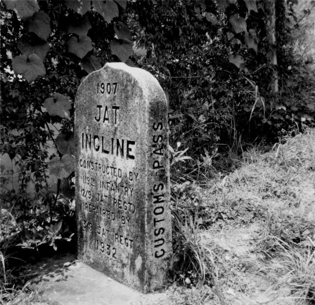
This just says Jat Incline but it seems to be the same marker stone posted recently by moddsey. The inscription is easy to read and the dates of 1907 and 1932 appear on the face with Customs Pass on the side.
Pauline.
Date picture taken
11 Jul 1954
Gallery
Shows place(s)
Comments
Re: Jat Incline Marker
Pauline - nice photo. Jat Incline was the road that was built by the JAT Regiment between Tate's Cairn and Customs Pass.
My photo: http://gwulo.com/node/8688 was taken at the junction with Customs Pass, Clearwater Bay Road. I would not be surpriesed if there is another identical marker on Tate's Cairn.
The left side face of the marker reads Tate's Cairn whilst the right side shows Customs Pass.
Thanks moddsey, Your Jat
Thanks moddsey,
Your Jat Incline Marker looks much newer and shorter than mine doesn't it, do you think it is a replacement for the one in my husband's photo or are they two different markers altogether?
Pauline.
Re: Jat Incline Marker
When my photo was taken it did occur to me at the time that the marker appeared to be 'newer'. As you can see it was placed deeper into the ground. On the to do list next visit to find the other marker, i.e. if there is one.
Re more than one Jat Incline marker
Good hunting. I shall look forward to seeing a photo of the other marker if you find one.
Pauline.
Re: Jat Incline Marker Stone
No luck in finding a second marker near Tate's Cairn.
Here are photos of the exisiting marker stone. I have created a place for it.
Re: Place for Jat incline Marker Stone
Hi Moddsey,
Another nice batch of photos. Do you think this is 'my' marker stone cleaned up and repositioned it looks like it to me although it is deeper in the ground. I am finding the history of my late husband's time in HK fascinating and all these kind comments on photos help me to build up a picture, he seems to have travelled around quite a lot and I am now trying to identify the launch in his photos of the "G" Branch outing to Lamma Island. I know the RASC had a launch called HUMBER.
Thanks again, Pauline.
Re: Jat Incline Marker Stone
The old marker could have been cleaned up with a new coat of paint but the shape of the stone looks strikingly similar to your photo. It is not improbale that the stone was relocated sometime later. Regards.
typeface
Look closely at the two stones and you will see that moddsey's has a slightly different typeface to Pauline's. They're not the same stones.
1930 -1933 JAT Regiment
The Jat Regiment was an Indian infantry regiment that helped construct Jat's Incline from Customs Pass to Tate's Cairn around 1907. Information on the 3/9th. Regiment from the 1930s can be found here
The marker stone at Customs Pass was repaired before the regiment left Hong Kong on 21 December 1933.
Jat Incline Marker / Jat's Incline Marker
Thanks for bringing up the Jat's Incline marker stones: those of the 1954 and 2020 photographs (https://gwulo.com/atom/14567 and https://gwulo.com/atom/14567#comment-17296) are clearly different: note the relative position of 'Jat' and 'Pass', '1932' and 'Customs', the relative surface weathering, and the relative orientation relative to the slope. Presuming that the 1996 (https://gwulo.com/atom/14561) and 2020 images show the same marker, the location of the marker stone seen in 1954 remains unknown. Is it in keeping with the local geography for a marker stone at the top of Jat's Incline to have Custom's Pass marked on its right hand side, or could the 1996/2020 feature be a replacement marker installed in the downslope end of Jat's Incline after 1954?
A brief aside: the slope cuttings exposed on Jat's Incline were a major part of the paper Weathering of Granite and Associated Erosional Features in Hong Kong by Ruxton and Berry (1957), which became a classic model of rock weathering still used by geologists and engineers around the world. On a visit with Professor Cliff Ollier in 1993/1994, he was disappointed to see cuttings that he'd visited before (I believe with Bryan Ruxton) and had reported in Ollier (1969) Weathering (see image on p199) were covered by chunam/shotcrete since his last visit, and that Jat's Incline no longer had the educational value he'd remember.