Moddsey writes:
Cox's Path Government Quarters were completed in 1914. The buildings consisted of 8 two-storied houses with detached servants quarters. Each house had a small plot of ground in front and a small yard in the rear.
The quarters were for subordinate officers of the Government and directly faced Cox's Road and the Kowloon Cricket Club. Staff of the KCR were temporaily housed there.
The quarters were built mainly of Canton red brick.
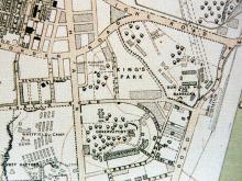
It's worth noting that a 1924 map of the area shows what we call Cox's Road today was named Cox's Path in 1924. Today's Cox's Path didn't exist on that map.
I've guessed the demolition date as 1950, based on the fact that Morse House opened on this site in 1954. However the buildings may have lasted a couple of years longer - or indeed may have suffered wartime damage and been demolished earlier.
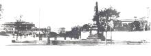
There was another block in a different style built behind, and slightly above these a few years later. If you look at the far left of this photo (click to zoom in), you can see both the upper and lower blocks:

Photos that show this Place
Comments
Cox's Path ( Lower)
David, is it possible for you to upload that 1924 map?
1924 Map of Cox's Path
Rich, here's the map (click map for larger copy):
Unfortunately it doesn't give much detail about the shape or layout of this lower block of quarters.
Curious that there's no sign of the upper block. I'm not sure if that means:
re: 1924 Map of Cox's Path
Rich writes:
Unfortunately this map is not detailed enough solve the mystery of Cox's Path lower and upper, [...] Are more detailed maps available of this area and era? I guess it would mean a visit to the archives.
I haven't seen any more detailed maps, but they should exist. Some suggestions for map archives here.
If the upper and lower blocks were standing after the war, a better bet might be to contact the Public Works Department (or whatever they are called now). A couple of people have posted other buildings' layouts from the PWD, drawn post-war.
I've never contacted them though. Can anyone share their experience of getting copies of PWD plans?
PWD maps from Lands Dept
I have several sets of PWD maps that were at the Lands Department in the North Point Govt Offices (Quarry Bay MTR station, Exit C).
You search their maps year by year, and some I was looking for popped up - originally PWD maps.