Current condition
In use
Reclamation means it isn't an island any more.
It is the site of the Royal Hong Kong Yacht Club.
Photos that show this Place
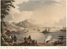
1843

1853
1860
Reclamation means it isn't an island any more.
It is the site of the Royal Hong Kong Yacht Club.
Comments
... or Lantern Island (燈籠洲)
The Chinese names are older and can be more poetic - and have more history for us :)
Kellett Island
They are not always older. The written Chinese of today is not always - or sometimes even often - an accurate rendering of an original colloquial name (<95% of Chinese coastal inhabitants were not literate in Chinese when Samuel Wells Williams was writing in the 1850s). Quite often (my suspicion is quite surprisingly often) a Chinese name is a post-mapping, post-colonial occupation creation with nicely literate names that have no connection with the sort of salty names seafarers and fisherfolk are likely to have used (q.v. Dog's Bum Island off Cape D'Aguilar). Little thorough work has been done on local toponymy, and too much of what has been done rests on the shakey foundation of folk memory often under three generations old. That's not to say 'Lantern Island' (燈籠洲) is NOT the original name, merely that it is indeed the Chinese name in use today but there is not much evidence to support the claim that it is original.
On a Japanese intelligence map of 1939, there's another name altogether, but my Kanji isn't up to reproducing it. Which leads me to a question for Gwulo mavens.
Has anyone ever heard what, if any, use Kellett Island had during the Battle of Hong Kong. I know that the last yacht race finished only about 18 hours before the first bombs fell, so clearly it wasn't requisitioned for military use at that point. However, given the decision to scuttle ships, including the Tamar, to prevent the Japanese using them for OPs or platforms for offensive action, it boggles the mind that Kellett Island that, with a heavy machine gun or some light artillery, dominates the Wan Chai waterfront and the road connection between Wan Chai and North Point, was ignored by both sides, as appears to have been the case. Anyone any ideas?
Stephen D
Kau Pei Chau has wrong Chinese name
Hi Stephen,
The original Chinese name of the island off Cape D'Aguilar was 筊杯洲 which refers to the shape of the island being like moon blocks, a divination tool. As old maps produced by the colonial government or British military are in English, I suspect that at some point someone tried to translate the English name "Kau Pei Chau" back to Chinese, and thought the name was 狗髀洲 (Dog Thigh Island)!
Mr. WONG Dit Wah (黃垤華) wrote quite a few books (in Chinese) on local toponymy and they are gradually being edited and published. Two have come out in the past few years, and hopefully there are many more to come.
Toponyms
Hi C,
Thanks. I think you have made my point rather better than I had managed to. The earliest rendering of the name in Romanized form begining in c.1896 (the Royal Engineers resurvey of Lt Collinson's 1845 map), which lasted until c.1941, was Kau Pui Chau. Post-war (the first GSGS OS map 1945) it became Kau Pi Chau (one is minded of the 'flowery arse' Fuzhou pole junk the hua pi gu (花屁股)) until the late 1960s when it took its present Romanized form of Kau Pei Chau (1969 - Directorate of Overseas Survey, 1:10,000, 1969) that, as of c.1987 (Govt of Hong Kong, 1:20,000, 16 sheets 1987-1991), acquired the Chinese characters that you and Mr Wong so blithely dismiss, though with no reference to maps or any other specified data sources.
What would be interesting would be to learn of Mr Wong's detailed toponymical etymology with its dating - i.e. which source is dated to exactly when, and in reference to what and how, if at all, that relates to or was derived from any local, orally transmitted toponym and what that source was.
For the last decade I've been part of a team of scholars from Academia Sinica, Paris, the Netherlands, Belgium and Germany interested in traditional Chinese navigation and, naturally, we have much concerned ourselves with the zhenjing (針經) and their toponymies. The points of interest in the latter in relation to names like Kau Pei Chau/狗髀洲 /筊杯洲 is how they do not always overlap (i.e. names given to a feature in a Xiamen zhenjing do not always match all of those with all those from Shantou, or Penghu, or...), nor do the names in zhenjing from a single location always show consistency through time for a single feature.
An example would be what westerners know as Pedro Blanco. It's toponym today is Zhenyantou (鎮堰頭 - I shall not venture a translation, though I think I have the sense!) In one of the zhenjings I have helped decipher it is called (sensibly and in a very seafarerlike way) Dajian (大尖 - Big Point/Needle). Needless to say this had been a puzzle because the non-sailing, non-navigating scholars fixated on traditional written toponyms had managed to place Dajian in the north of Daya Wan where there is today (and one assumes was in gazetteers in the past, which would entirely have ignored an offshore rock) a rather unassuming peak called Dajian Mountain (大尖山). Once I pointed out the navigational nonsense that resulted from such a maritime illiterate conclusion, we agreed - because it made perfect navigational sense of the zhenjing directions - that a local, seafarer toponym for a needle rock (as it is when seen from east or west (I've sailed round it a few times)) was, probably unsurprisingly, 'Needle Rock' - western 'views' of it from those bearings, made in the 1760s (yes, 1760s) show clearly why the name fits.
Whilst it is easy to try to account for stuff by referencing Sino-illiterate English surveyors (who, of course, of course, never had the sense or courtesy to consult anyone Chinese, leave alone the local seafarers who actually used the name), I am not sure it is of much help.
One of the sources the team I'm part of is working on just now is a list of 540 toponyms from The Ninepins eastward to the Zhoushan Islands collected by Captain Richard Collinson in 1842-1844 during his surveys of the coast. The list is in his manuscript surveying notebook in the UKHO archive (which means that students of local toponymy have to go beyond only Chinese sources) and has a most interesting layout. It is in six or sometimes seven columns. The first gives the English name if there was one, as that had emerged over the period 1600s-1840s and otherwise a very brief topographical description. Then came a column with the name in Chinese characters. Then a column with a (somewhat eccentric) Romanization of how the name sounded in Fujianese. Then a column similarly less than consistently Romanized, of how it sounded in Mandarin. (Note, never Cantonese or Ningbonese despite the coasts of Guandong and Zhejiang being exclusively covered.) And then two columns giving the feature's geographical coordinates in latitude and longitude. Finally one with any other informative remarks.
The tables are NOT complete - only nine entries have data in all the columns. The most obvious point one can infer is that Captain Collinson's embarked pilot was Fujianese (Fujianese seafarers dominated the southern Chinese maritime world) and very probably illiterate (see the point about literacy in Chinese 19th century seafarers in my last). From the pilot and, no doubt, his interactions with mostly illiterate informants, Collinson derived his long lists of how names SOUNDED in the two language variants he thought important. I suspect subsequently, (that's because, of the 540 toponyms, only 103 examples (19%) appear with their Chinese characters), probably with the assistance of his embarked pilot, he got a literate scribe working with the Royal Navy here in HK to help him come up with a written form of the hundreds of names he had learned. That the list was 80%+ incomplete suggests to me the extreme difficulty of coming upon any agreed written forms as between a literate but non-seafaring scribe and an illiterate but seafaring informant.
For the basic problem here is that Chinese languages have a quite startling number of homophones (I hardly need to write this!), so for any set of approximated sounds in a phonetic transcription, a number, likely rather a large number, of possible 'correct' variants in characters can be come upon, some more 'respectable' than others. As much to the point, there are occasional toponymical terms in Hong Kong that most dictionaries I use respond to by saying 'not in dictionary', or with a set of meanings that seems to bear no relationship to the actual toponymical use - for example 排, used on the Guangdong coast to mean something like 'rock' or 'reef', that in most written Chinese seems to have no obviously related meaning. One suspects that Guangdong coastal dwellers had a 'sounds like' pai referent, probably related to a pre-Han language that was 'found' a Chinese character that did the phonetic job (see No. 61 in the list of 129 possibles in K.M.A. Barnett, "Do words from extinct pre-Chinese languages survive in Hong Kong place names?", JRASHK, vol. 14, 1974, pp.136-159).
At this point a diversion that I hope will be helpful, although I recognize that higher civilizations may not be susceptible to explanations derived from lesser and more vulgar groupings.
Back until the late 16th century in Britain, there was a very common upland bird called, for quite sensible reasons - it had a white rump - a whitearse (the French are less absurdly mealy-mouthed, so still call the bird un cul blanc). It was about this time that printed works in the vernacular were beginning to take off as well as the beginnings of a taxonomic interest in the natural world. Of course the people who compiled and consumed the new printed materials were not from society's vulgar levels, so were disposed to frown on names that were so blatantly gross - here the problem was that English spelling was only beginning to settle down, so 'arse' was as often written 'ears', although pronounced the same way. So there was a perfect side-step and at some point as of around 1590 - no one is quite sure when and where - 'whitearse' became genteely re-rendered into 'wheatear' - the sort of pronunciation polite people with 'nice' manners could exchange in public and in front of ladies, despite the fact that the bird in its natural habitat has nothing to do with fields of wheat and is never found in them, nor does it look like an ear of wheat. Come the mid-18th century and the Linnaean system, such embarrassments could be stepped around with Oenanthe oenanthe (and in Hong Kong's cases Oenanthe pleschanka (白頂(即鳥)) and Oenanthe deserta (漠䳭). (You will find those two local variants (the pied and desert wheatears) in the Hong Kong Birdlist (https://digital.lib.hkbu.edu.hk/hkwildtracks/species.php), though of course the Chinese terms, like the colloquial English one, do their own thing).
So, my simple point is (and was) that local toponyms are usually pretty straightforward and seldom poetic wherever one is in the world (though, of course, in China perhaps things are different). Any claim to an 'original' name has to be supported by some very robust AND MULTIPLE references showing the when, where, and who of the usage as well as showing EXACTLY when, where and by whom the original was transformed into a later form. Waving one's hands and claiming X is the original and Y not, does not constitute an argument, merely an assertion. It seems clear that there was a local toponym for the islets off Tylong Head (1841)/Cape D'Aguilar (1845-today)/Tai Long Head (1897-c.1957)/Hok Tsui (1962-today) (nice set of variants there - I wonder which one is 'correct'?) and that it sounded like Kau Pui/Pi/Pei Chau. The data needed to decide what was indeed the local toponym before literate mapmakers got onto the job would seem to me to be distinctly lacking.
We gweilos are an ignorant bunch, to be sure, but we do try to understand what we write about.
Best,
StephenD
Just to add to things
I provoked myself to wonder a bit more about Pedro Blanco, since the referents I was using were mostly early 19th century and, via Google Earth and some rootling around, what I could find using English searching.
So, I updated my gweilo topnymy by sourcing the first English language set of sailing directions that I know of that did its best to include Chinese translations of all the toponyms it used. That was John R. Morrison's, A Chinese Commercial Guide, 3rd edition, 1848. Pedra Branca, as Morrison correctly styles it, comes up on p.73. Morrison's orthography for the Romanization was Taesingchan or, in characters, 大星簪.
So, to add to the jollity I thought I'd try a search in Chinese (natch within my very, very limited skills) and, by using John Morrison's Chinese toponym, discovered a most fascinating Chinese Wikipedia site. Interestingly, rather than the entry using the official (and presumably original and correct) Chinese toponym, the website was titled with the mid-19th century name, with the official name listed way down as a possible alternate among many. Does that make 大星簪 original, or should we stick with the earlier (and more original? (even if probably Fujianese)) 大尖? Tricky.
For the website vouchsafed a marvellous torrent of 'variations on a theme' alternatives: 大青針 (Daqingshan - Big Blue Needle), 大星簪岩 (Daxingzanyan (Big Star Hairpin), 大星簪礁 (Daxingzanjiao - Big Star Hairpin Reef), 針頭岩 (Zhentouyan - Needle Head Rock - which, q.v. above, is the name registered by the PRC in its (rather aquisitively cheeky and flouting of the spirit of the rules) UN Law of the Sea declaration of its territorial sea baseline), 大青針島 (Daqingzhendao - Big Blue Needle Island), 針頭岩島 (Zhentouyandao - Needle Head Rock Island), and what the westerners call it, translated into Chinese from the garbled Spanishy-Portuguesy-Anglo bastardization (the original Portuguese, as John Morrison reminds us, was Pedra Branca), 白石 (Baishi - White Rock).
(Pedro Blanco, by the way, is a person's name (Peter White). One notorious maritime Pedro Blanco (1795-1854) was a Spanish slave trader working out of Sierra Leone. The Spanish would be Roca Blanca or Piedra Blanca.)
So being stipulative about coastal toponyms in our waters in ANY LANGUAGE doesn't really stand up to much careful scrutiny.
StephenD
Toponyms and Pedro Blanco
Dear Stephen,
Thank you very much for your detailed comments and expert opinions about toponymy, from which I benefited a lot. I must point out that when I wrote my comment, the dismissal of the name "Dog Thigh Island" was entirely my own opinion. I was not referring to Mr. Wong's books.
Through an intermediary, I informed Mr. Wong about this thread. He wants me to add some comments on his behalf.
Mr. Wong said he is not conducting formal toponymic research. Rather, the aim of his work is to organise and preserve place name information as it is (or was) known to the local people. Some names are rude but he documents them as they are, so readers can understand the roots of the names.
About names not overlapping in zhenjings from different regions, Mr. Wong is not surprised as it can happen due to the variation of dialects and local accents. Also, villagers and fishermen may name coastal places and features differently.
Mr. Wong agrees that Kau Pui Chau (珓杯洲, Moon Block Island) is the more correct name based on his interviews of local villagers and fishermen several decades ago. The pair of islands are shaped like moon blocks (珓杯 or 筊杯) alongside each other. The name was corrupted to Kau Pei Chau (狗髀洲, Dog Thigh Island) on government maps, likely due to phonetic similarity.
Based on his notes and visit(s) to the region, he believes the local name of Dajian Mountain (大尖山, Big Point Mountain) is Daxing Shan (大星山, Big Star Mountain). About Pedro Blanco, he supports the name 大星簪 (Daxing Zan, Big Star Hair Stick), again based on interviewing fishermen in Sai Kung and locals in Pinghai, Huidong County. They all informed him of this name. Due to the rock's sharp appearance, local legend said that a female deity dropped her hair stick into the sea which became the rock.
Also, this rock is quite conspicuous from the sea. It and the mountain Daxing Shan together form a pair of landmarks. Therefore, someone named the rock Daxing Jian (大星尖, Big Star Sharp) based on the mountain's name. Mr. Wong is of the opinion that both names 大星簪 (Daxing Zan) and 大星尖 (Daxing Jian) can coexist.