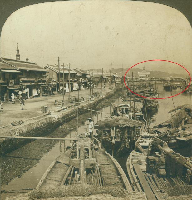
I think those are minarets sticking above the roofline on the left hand side. So I guess that means you are looking at somewhere very close to a mosque.
The bridge you highlighted looked very much like a railroad bridge. I could not recall anything similar except in Taipo, but the bridge & Houses in Taipo did not look like those in the photo. Conclusion, it is very unlikely that the photo had anything to do with Hong Kong.
The style of the wooden houses, as well as the straw hats did not look right too.
The lady on the left is wearing Kimono with an Obi (sash). The mountains in the background are less likely to be Malaysia. I think Japan has lots of hills and mountains. I guess this is Japan somewhere.
I have a strong inkling this is a canal in Yokohama, Japan.
There are Japanese people, elements of Western architecture mixed with east Asian, and shallow draft boats in a canal with bridges. It's a short list of places. The architecture of the buildings and shop fronts are those of late 19th century Yokohama.
I have come across an image which I believe shows the exact same place but from the opposite end (and at a slightly later date)
The link photo was taken from the bridge that was circled in red oval in the opening post of this thread. And vice versa, the photo from the opening thread was taken from the bridge that can be seen spanning across the canal at centre left in the link photo. In particular in the link photo, the arched metal bridge (towards the right of the link photo) with the concrete barriers seen at the end of the metal arches looks exactly the same as the bridge seen in the opening post near the centre just to the left of the red oval..
It's a valid point Peter now that you mentioned it. I don't know where exactly this canal scene is in within the city of Yokohama (if it is that) but the darkened stonework along the bank indicating how high the water level can rise and fall seem to be about that range you quoted once you compare the height of people in the photo and the link photo.
Thanks eurasiandavid. Your discussion on the comparison between the main photo and link photo is convincing. I noted that the power line posts, and roof lines on the two photos are similar.
One old photo of the city shows there were at one time two water courses flowing to the sea - one northwest of the harbour (today's starting point Kitanakadorikita Daiichi Park), and the other to the south east (K3 Route). The main/top photo could be in either one of them. I think that the location was close to the sea/harbour if the photo was taken for a visitor. Regards, Peter
Comments
Minarets?
I think those are minarets sticking above the roofline on the left hand side. So I guess that means you are looking at somewhere very close to a mosque.
Not Hong Kong
I don't think this is Hong Kong
Re: Unknown #2
Hi there,
The bridge you highlighted looked very much like a railroad bridge. I could not recall anything similar except in Taipo, but the bridge & Houses in Taipo did not look like those in the photo. Conclusion, it is very unlikely that the photo had anything to do with Hong Kong.
The style of the wooden houses, as well as the straw hats did not look right too.
My 2 cents,
T
I do agree with you. I'm
I do agree with you. I'm surprised that H. C. White made such a mistake.....
actually there looks to be
actually there looks to be two bridges, the other one to the left facing away.
In hindsight this looks more like a scene from somewhere in Malaysia.
Japan
The lady on the left is wearing Kimono with an Obi (sash). The mountains in the background are less likely to be Malaysia. I think Japan has lots of hills and mountains. I guess this is Japan somewhere.
Belz
Canal in Yokohama, Japan
I have a strong inkling this is a canal in Yokohama, Japan.
There are Japanese people, elements of Western architecture mixed with east Asian, and shallow draft boats in a canal with bridges. It's a short list of places. The architecture of the buildings and shop fronts are those of late 19th century Yokohama.
I have come across an image which I believe shows the exact same place but from the opposite end (and at a slightly later date)
Canal at Yokohama, Japan
The link photo was taken from the bridge that was circled in red oval in the opening post of this thread. And vice versa, the photo from the opening thread was taken from the bridge that can be seen spanning across the canal at centre left in the link photo. In particular in the link photo, the arched metal bridge (towards the right of the link photo) with the concrete barriers seen at the end of the metal arches looks exactly the same as the bridge seen in the opening post near the centre just to the left of the red oval..
Canal in Yokohama, Japan
Greetings! It looks like this part of the canal has sea tide with a total range of 4 to 5 feet. This is only a very rough look - https://www.tide-forecast.com/locations/Yokohama-Japan/tides/latest
(1.7 metres - 0.1 metre) / 0.3048 = 5.25 feet
Could this be a hint supporting Yokohama? Regards, Peter
It's a valid point Peter now
It's a valid point Peter now that you mentioned it. I don't know where exactly this canal scene is in within the city of Yokohama (if it is that) but the darkened stonework along the bank indicating how high the water level can rise and fall seem to be about that range you quoted once you compare the height of people in the photo and the link photo.
Canal in Yokohama, Japan
Thanks eurasian david. Your discussion on the comparison between the main photo and link photo is convincing. I noted that the power line posts, and roof lines on the two photos are similar.
One old photo of the city shows there were at one time two water courses flowing to the sea - one northwest of the harbour (today's starting point Kitanakadorikita Daiichi Park), and the other to the south east (K3 Route). The main/top photo could be in either one of them. I think that the location was close to the sea/harbour if the photo was taken for a visitor. Regards, Peter
Re: Photo Location
Good work. Yes, it is Kanagawa, Yokohama. The confirmation can be seen here Taken in 1901 by Clarence H White.