Funnily enough I have some photos from my late Father-In-Law's collection (I have spent the last few years believing them to be an unidentified town in Malaysian Borneo - where he worked as a railroad coolie in the 50's). I only recently recognised these photos as an old panorama of my current home town.
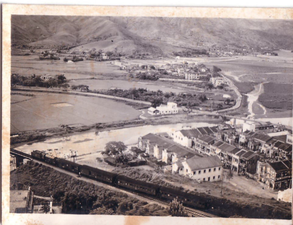
The first photo below shows the Lam Tsuen river and KCR bridge with a KCR train on it of course. Also I note there are some two-storey columned shophouses. Looking at the angle I would say that the pictures were taken in the hills above Pun Chung village.
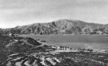
The following picture shows the Tolo Harbour with the identifiable ridge of Pat Sin Leng in the background (this is what eventually made the penny drop).
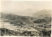
The final part of this veritable feast for the eyes shows another angle over Tolo Harbour with the KCR track at bottom right. About mid-picture on the right-hand-side is what looks like a clump of trees floating in the water. This is Yuen Chau Tsai, location of Island house and if you squint you may be able to see some boats moored around it. Its possible these are boats similar to the ones taken by Hedda Morrison at that location in the 40's.
Phil, what a great view of old Tai Po. Comparing the above satellite map with the first photo, the road that follows the river bank and then curves up and off into the distance is Ting Kok Road. Hard to imagine today that it once ran along the seafront!
Also it looks like the skinny road bridge in that photo still exists today, judging by the satellite view. It looks like it was the only road crossing in the 50's, so would Booth have driven across that?
I think photos #2 and #3 would stitch together nicely to make a panorama. Unfortunately there doesn't look to be any overlap between #1 & 2, or we could have made a good panorama from the whole set.
Great photos, Phil! Now that is what I call "countryside". In the third photo, would the hill below or where the photographer was standing be where the former Tai Po District Office was located?
I've been up to the same spot (or thereabouts) today and unfortunately there is absolutely no way to get a comparison today due to 1) the number of high-rises that now cover both sides of the river and 2) the vantage point is now rather densely covered with tall trees and as Pan Chung village has grown up the side of the hill, I believe the actual position is inaccessible - possibly now part of someone's garden or house.
The vehicular bridge in the background is Kwong Fuk Bridge. A pedestrian bridge now stands in its place. The nearest route over the river now is Po Heung bridge, which would be further down the river. There are a couple of buildings still standing today: of course the old KCR station which now houses the railway museum - hidden in the clump of trees at the bottom of the right hand picture. A little further to the right is a white rooftop with a pole on the roof (looks like a cross here, but it isn't) - this is how I know where the picture was taken - this building is still there!!! I think its name is "Chiu Lo" and you can still see it from the intersection of Heung Sze Wui Street and Po Heung Street at the western end of the Tai Po complex. It's a private residence (I think) with what looks like extensively landscaped gardens that have now sadly fallen into severe disrepair and neglect.
Moddsey - do you mean "The Old District Office North" (which now houses the Scout Association)? If so, this is on one of the hillocks on the far right photo. I've added a note on FLICKR to pinpoint it (as well as a few other places)
Yes, the road on the other side of the river would be the rough line of where Ting Kok Road currently starts, the white building in front occupying roughly where the Govt offices are today. I will need to go back and do a bit more snooping around without getting myself arrested for loitering.
It's a bit of a shame, but my mother-in-law has told me that she had a pile of old photos of (of Hong Kong and Tai Po in the 50's 60's and 70's) which were left behind when she moved to the UK in 1973. My father-in-law had gone over a year or so before to get settled down, and she had to make her own way there with 4 young kids in tow - the youngest being my wife who was 9 months old at the time. No space for photos!
Yes, I was thinking about the Old Tai Po District North Office on the hill next to the Police Station. I now recall, the Old District Office had an obstructed view of the KCR railway prior to its entry into Tai Po proper. So the last photo would be 'slightly off the mark' from what I originally thought. Cheers.
I found this on their website. A similar (but higher up I think) angle to the main one above.
It looks like the main vehicular road remained for quite some time - it looks like an extension to Kwong Fuk Rd. Kwong Fuk Rd now basically ends where it encounters the river, curves left and becomes Pak Shing Street. That part of the crossing is now completely pedestrianised.
Incidentally this angle does include the hillock contain the old district office - immediately to the RHS of the tallest block on the right (on the LHS of that building in the background is Yuen Chau Tsai again).
Thank you for posting the 3 photos of Tai Po. It's amazing to look at them. It brings back a lot of my memory. The little village situated close to the middle bit of the 1st photo is the Tai Po Old Market where I was born in 1951. The New Market is at the bottom to the right. I used to walk along Ting Kok Road by the sea side, cross Kwong Fuk Bridge, then along the Lam Tsuen River, to school when I was little. Tai Po Public Primary School was just right at the first building of the bottom row by the river. The village at the far top right is Nam Han, and Sun Wai Tsai at the left. I have probably left trails of my footsteps all over the places. I used to catch crab and fish at the mangrove area to the left. Now is the prosperous Tai Po Business Centre. I have immigrated to the UK since 1973 and I would love to see more of the photos, especially the Old Market. Thanks again
Hi Sam - good to hear some old memories. If you go to the FLICKR page for these I have started to add some notes identifying some of the buildings. Feel free to add some if possible. Cheers Phil
Phil has written an interesting article describing Tai Po Market's development, from 1892 through to 1964. The development happened in several distinct phases, and he's marked up each of these on a present-day satellite view, to make it easy to match them up with today's Tai Po.
Comments
Tai Po in the 50's
Funnily enough I have some photos from my late Father-In-Law's collection (I have spent the last few years believing them to be an unidentified town in Malaysian Borneo - where he worked as a railroad coolie in the 50's). I only recently recognised these photos as an old panorama of my current home town.
The first photo below shows the Lam Tsuen river and KCR bridge with a KCR train on it of course. Also I note there are some two-storey columned shophouses. Looking at the angle I would say that the pictures were taken in the hills above Pun Chung village.
The following picture shows the Tolo Harbour with the identifiable ridge of Pat Sin Leng in the background (this is what eventually made the penny drop).
The final part of this veritable feast for the eyes shows another angle over Tolo Harbour with the KCR track at bottom right. About mid-picture on the right-hand-side is what looks like a clump of trees floating in the water. This is Yuen Chau Tsai, location of Island house and if you squint you may be able to see some boats moored around it. Its possible these are boats similar to the ones taken by Hedda Morrison at that location in the 40's.
re: Tai Po in the 50's
Phil, what a great view of old Tai Po. Comparing the above satellite map with the first photo, the road that follows the river bank and then curves up and off into the distance is Ting Kok Road. Hard to imagine today that it once ran along the seafront!
Also it looks like the skinny road bridge in that photo still exists today, judging by the satellite view. It looks like it was the only road crossing in the 50's, so would Booth have driven across that?
I think photos #2 and #3 would stitch together nicely to make a panorama. Unfortunately there doesn't look to be any overlap between #1 & 2, or we could have made a good panorama from the whole set.
Regards, MrB
Tai Po...
Wish it still looked like this!!
Tai Po
Great photos, Phil! Now that is what I call "countryside". In the third photo, would the hill below or where the photographer was standing be where the former Tai Po District Office was located?
Old Tai Po
I've been up to the same spot (or thereabouts) today and unfortunately there is absolutely no way to get a comparison today due to 1) the number of high-rises that now cover both sides of the river and 2) the vantage point is now rather densely covered with tall trees and as Pan Chung village has grown up the side of the hill, I believe the actual position is inaccessible - possibly now part of someone's garden or house.
The vehicular bridge in the background is Kwong Fuk Bridge. A pedestrian bridge now stands in its place. The nearest route over the river now is Po Heung bridge, which would be further down the river. There are a couple of buildings still standing today: of course the old KCR station which now houses the railway museum - hidden in the clump of trees at the bottom of the right hand picture. A little further to the right is a white rooftop with a pole on the roof (looks like a cross here, but it isn't) - this is how I know where the picture was taken - this building is still there!!! I think its name is "Chiu Lo" and you can still see it from the intersection of Heung Sze Wui Street and Po Heung Street at the western end of the Tai Po complex. It's a private residence (I think) with what looks like extensively landscaped gardens that have now sadly fallen into severe disrepair and neglect.
Moddsey - do you mean "The Old District Office North" (which now houses the Scout Association)? If so, this is on one of the hillocks on the far right photo. I've added a note on FLICKR to pinpoint it (as well as a few other places)
Yes, the road on the other side of the river would be the rough line of where Ting Kok Road currently starts, the white building in front occupying roughly where the Govt offices are today. I will need to go back and do a bit more snooping around without getting myself arrested for loitering.
Tai Po photos
It's a bit of a shame, but my mother-in-law has told me that she had a pile of old photos of (of Hong Kong and Tai Po in the 50's 60's and 70's) which were left behind when she moved to the UK in 1973. My father-in-law had gone over a year or so before to get settled down, and she had to make her own way there with 4 young kids in tow - the youngest being my wife who was 9 months old at the time. No space for photos!
Tai Po Photos
Yes, I was thinking about the Old Tai Po District North Office on the hill next to the Police Station. I now recall, the Old District Office had an obstructed view of the KCR railway prior to its entry into Tai Po proper. So the last photo would be 'slightly off the mark' from what I originally thought. Cheers.
HK Public Library photo
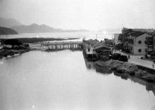
I found this on their website. A similar (but higher up I think) angle to the main one above.
It looks like the main vehicular road remained for quite some time - it looks like an extension to Kwong Fuk Rd. Kwong Fuk Rd now basically ends where it encounters the river, curves left and becomes Pak Shing Street. That part of the crossing is now completely pedestrianised.
Incidentally this angle does include the hillock contain the old district office - immediately to the RHS of the tallest block on the right (on the LHS of that building in the background is Yuen Chau Tsai again).
Tai Po
Dear Philik
Thank you for posting the 3 photos of Tai Po. It's amazing to look at them. It brings back a lot of my memory. The little village situated close to the middle bit of the 1st photo is the Tai Po Old Market where I was born in 1951. The New Market is at the bottom to the right. I used to walk along Ting Kok Road by the sea side, cross Kwong Fuk Bridge, then along the Lam Tsuen River, to school when I was little. Tai Po Public Primary School was just right at the first building of the bottom row by the river. The village at the far top right is Nam Han, and Sun Wai Tsai at the left. I have probably left trails of my footsteps all over the places. I used to catch crab and fish at the mangrove area to the left. Now is the prosperous Tai Po Business Centre. I have immigrated to the UK since 1973 and I would love to see more of the photos, especially the Old Market. Thanks again
RE: Tai Po
Hi Sam - good to hear some old memories. If you go to the FLICKR page for these I have started to add some notes identifying some of the buildings. Feel free to add some if possible. Cheers Phil
re: Tai Po
In case it's not clear, you can click on any of the three photos above to visit their Flickr page, and see the notes that Phil mentions.
Tai Po History
Phil has written an interesting article describing Tai Po Market's development, from 1892 through to 1964. The development happened in several distinct phases, and he's marked up each of these on a present-day satellite view, to make it easy to match them up with today's Tai Po.
If you're interested in Tai Po, also check out Phil's other articles about Tai Po's history.
Regards, David