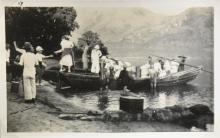
The actual starting point should have been the Tung Chung Pier. The old pier seemed to be gone but if you zoom in from Google Earth the location is still there.
I went there last Sunday and found much of the original path from the Pier through the various villages to 'Shek Mun Kap' village and then up the slops is still there. Part of it is gone during the establishment of the public housing estate Yiu Tung Estate. Two (or was it three) schools and a plaground now are in between Shek Mun Kap and the temple mentioned.
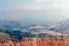
The map shows several ferry routes to and from the pier. There is still a pier there today. Perhaps it was the site of the "rickety wooden pier" where Booth got off the navy launch?
Back in the Yaumati Ferry days, there is a route going from Central to Tai O, which would stop at Tung Chung and Sha Lo Wan. That is an awfully slow route and the schedule is just a few ferries a day for each direction. On weekend and Holidays there would be special ferries to Tung Chung. At the end of the pier there was also the Terminus of the Tung Chung line bus, running between Tung Chung and Silvermine Bay.
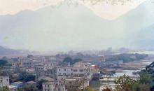
My impression of the old Tung Chung in the late 1970s was that it has some squatters like those in Tai O along the coast from the Pier to a bit inland. Back then, the old wooden plank/pier was still there, but I could not recall the exact location. It might be somewhere in the shallow water between the piece of sedimental land between the pier today and Yiu Tung Estate. Unfortunately I don't have any older photos of the area.
Some of the older houses are still around, however.
I was in Tung Chung again earlier. That was a column commemorating the inauguration of Tung Chung Road very close to the concrete pier, at the very starting point of Tung Chung Road right besides the old bus terminus. The engraving said the road was inaugurated by the Governor Sir David Trench KCMG in 1966.
Then in Booth's days the ony way to go to Tung Chung was either on foot from Silvermine Bay or Tai O, or by ferry.
I went to the Pier, and follow the same old path that Booth undertook back then. The path was right besides the new housing estate. I confirm the Hau Wong Temple, the road side shrine are still there. I think the remains of the wooden pier is still there as well. The government had built a concrete bridge for the villagers and despite the wooden pier is still there, it is in decay and not in use anymore.
The foot path is more or less the same until you reached the Shek Lau Po Village, where a small section had been muddled up by widened passage ways for vehicles of the villagers and redevelopment. Other than that, the orchids are still there.
I will try to mark the places. Oh, actually, there are three shrines on the way to Shek Mun Kap. One before reaching Hau Wong Temple which recognized right away, one at Shek Lau Po Village, and the other right at the Gate in Shek Mun Kap.
That's good - looks like you've tracked down Booth's path exactly.
Based on the engraved stone you saw above, I guess the concrete pier ('A' on the map above) may also have been built around 1966, as part of the road construction project.
Comments
Re: Tung Chung Pier
Hi there,
The actual starting point should have been the Tung Chung Pier. The old pier seemed to be gone but if you zoom in from Google Earth the location is still there.
I went there last Sunday and found much of the original path from the Pier through the various villages to 'Shek Mun Kap' village and then up the slops is still there. Part of it is gone during the establishment of the public housing estate Yiu Tung Estate. Two (or was it three) schools and a plaground now are in between Shek Mun Kap and the temple mentioned.
Best Regards,
T
re: Tung Chung Pier
Hi T,
I checked a 1980 map, and it shows this pier:
[gmap markers=letters::22.286641070398908,113.93418788909912 |align=Center |zoom=15 |center=22.285760840412344,113.93856525421143 |width=480px |height=350px |control=Small |type=Satellite]
The map shows several ferry routes to and from the pier. There is still a pier there today. Perhaps it was the site of the "rickety wooden pier" where Booth got off the navy launch?
Regards, David
Re: Tung Chung Pier
Hi there,
Back in the Yaumati Ferry days, there is a route going from Central to Tai O, which would stop at Tung Chung and Sha Lo Wan. That is an awfully slow route and the schedule is just a few ferries a day for each direction. On weekend and Holidays there would be special ferries to Tung Chung. At the end of the pier there was also the Terminus of the Tung Chung line bus, running between Tung Chung and Silvermine Bay.
My impression of the old Tung Chung in the late 1970s was that it has some squatters like those in Tai O along the coast from the Pier to a bit inland. Back then, the old wooden plank/pier was still there, but I could not recall the exact location. It might be somewhere in the shallow water between the piece of sedimental land between the pier today and Yiu Tung Estate. Unfortunately I don't have any older photos of the area.
Some of the older houses are still around, however.
Best Regards,
T
Tung Chun Wooden Pier/Tung Chung Road
Hi there,
I was in Tung Chung again earlier. That was a column commemorating the inauguration of Tung Chung Road very close to the concrete pier, at the very starting point of Tung Chung Road right besides the old bus terminus. The engraving said the road was inaugurated by the Governor Sir David Trench KCMG in 1966.
Then in Booth's days the ony way to go to Tung Chung was either on foot from Silvermine Bay or Tai O, or by ferry.
I went to the Pier, and follow the same old path that Booth undertook back then. The path was right besides the new housing estate. I confirm the Hau Wong Temple, the road side shrine are still there. I think the remains of the wooden pier is still there as well. The government had built a concrete bridge for the villagers and despite the wooden pier is still there, it is in decay and not in use anymore.
The foot path is more or less the same until you reached the Shek Lau Po Village, where a small section had been muddled up by widened passage ways for vehicles of the villagers and redevelopment. Other than that, the orchids are still there.
I will try to mark the places. Oh, actually, there are three shrines on the way to Shek Mun Kap. One before reaching Hau Wong Temple which recognized right away, one at Shek Lau Po Village, and the other right at the Gate in Shek Mun Kap.
Best Regards,
T
re: Tung Chun Wooden Pier/Tung Chung Road
That's good - looks like you've tracked down Booth's path exactly.
Based on the engraved stone you saw above, I guess the concrete pier ('A' on the map above) may also have been built around 1966, as part of the road construction project.
Regards, David