Hi Andrew, that is Kai Kung Leng which is the mountain immediately north of Shek Kong. In the photo we are viewing it from somewhere just west of Kam Tin I think - perhaps as far as near today's Pok Oi hospital area. I can't quite figure out if that little hill in the foreground is Au Tau area or not.
Thank you Phil. Your location fits very well with the 1952 map and the small hill definitely looks like Au Tau as seen on the map. My own memory is of taking photographs in 1958 and also 1981 on that stretch of road, not far to the East of Yuen Long. The map is a wonderful aid and I am constantly amazed and pleased to see how accurately it fits in with Google Earth. The Ordnance Surveyors and cartographers did a great job. Perhaps we should look again at my old photographs taken along that main road, and try to identify locatations using the 1952 map, especially one or two that show very distinct bends in a river, and perhaps mountains in the background. I recall that in about 2003, when I showed an old lady in Yuen Long my old photographs, she said that she knew where they were taken but that the rivers had been straightened and everything had changed. Now, we have the 1952 map to help us. Best wishes, Andrew
You're welcome Andrew. Thankfully this part of the NT has remained low rise so it is easy to find the general area. I also find this site quite useful : http://www.hkmaps.hk/mapviewer.html
This is the traditional style called "Yum Wah Lo 蔭華廬" (Father's name of the owner), "Sze Tze Uk, Lion Uk 獅子屋" (name from those two pair of gold plated lions deco at the front door) or "Pun Uk 潘屋" (House of Pun's clan). It is located at Au Tau of Yuen Long, next to the Pok Oi Hospital, the building was developed in 1932.
Comments
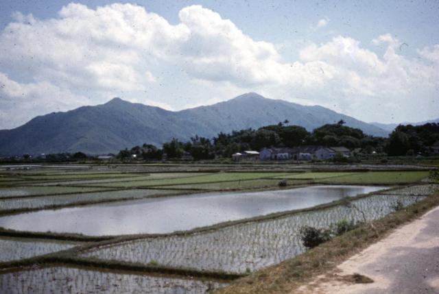
Kai Kung Leng
Hi Andrew, that is Kai Kung Leng which is the mountain immediately north of Shek Kong. In the photo we are viewing it from somewhere just west of Kam Tin I think - perhaps as far as near today's Pok Oi hospital area. I can't quite figure out if that little hill in the foreground is Au Tau area or not.
Thank you Phil. Your location
Thank you Phil. Your location fits very well with the 1952 map and the small hill definitely looks like Au Tau as seen on the map. My own memory is of taking photographs in 1958 and also 1981 on that stretch of road, not far to the East of Yuen Long. The map is a wonderful aid and I am constantly amazed and pleased to see how accurately it fits in with Google Earth. The Ordnance Surveyors and cartographers did a great job. Perhaps we should look again at my old photographs taken along that main road, and try to identify locatations using the 1952 map, especially one or two that show very distinct bends in a river, and perhaps mountains in the background. I recall that in about 2003, when I showed an old lady in Yuen Long my old photographs, she said that she knew where they were taken but that the rivers had been straightened and everything had changed. Now, we have the 1952 map to help us. Best wishes, Andrew
You're welcome Andrew.
You're welcome Andrew. Thankfully this part of the NT has remained low rise so it is easy to find the general area. I also find this site quite useful : http://www.hkmaps.hk/mapviewer.html
Fields east of Yuen Long
"Paddy", or perhaps PADI ?
Both spellings are correct.
Both spellings are correct, although Google translate seems to recognise just 'paddy'. Take your pick.
Padi...or Paddy??
Academic really, since it is the Malay word for “rice field” or alternatively “rice plant,” which has been “incorporated” into the English language.
i guess if one was to be pedantic the correct spelling would be “padi.”
This is the traditional style
This is the traditional style called "Yum Wah Lo 蔭華廬" (Father's name of the owner), "Sze Tze Uk, Lion Uk 獅子屋" (name from those two pair of gold plated lions deco at the front door) or "Pun Uk 潘屋" (House of Pun's clan). It is located at Au Tau of Yuen Long, next to the Pok Oi Hospital, the building was developed in 1932.
This is the location of the…
This is the location of the house in the photo, behind this house now you will see Pok Oi Hospital
https://maps.app.goo.gl/sanaD8KaW3N3VF5U7