Thank you so much - super exciting to see this. It is the house built by NDYP Inspector William Lysaught, who built a number of houses of similar size and slightly smaller on Wanchai Rd. This house became his home and was where he died in June 1910. He purchased the land - I.L. 1584 in 1902 - a 5500 sq ft plot, for $5,420 and built Homeville straight away (as was required by the Crown lease). The property was left to Caroline and Margaret Lysaught, his unmarried daughters, who ran it as a boarding house - sometimes from a distance when they were 'doing the season' in Cannes (! - not bad for girls who'd started life in the Inspector's crowded couple of rooms in the Dockyard ...) Barbara Anslow mentions staying here in her recollections of her childhood in HK. As most people will know by now, more information is in my Pollicing HK - an Irish History. Do you by any chance have photos of other houses in Wanchai Rd, Herostratus? Thanks again for posting this!
Hi Patricia. i have posted all the other photos of the area I have below. The house in the above picture is actually on IL1419 which is adjacent to IL1584 (see map below), was Homeville definitely on IL1584? The IL1584 building was directly behind this one. Below is a lot map of the area c1913.
The below is a photo taken showing the aftermath of a Typhoon c1936. The IL1584 building is at the end of the row of buildings to the right sticking out a little form the row of houses. The back of Wild Dell is on the left.
The below is a photo looking east down Wanchai road taken in the mid 1950s. The two buildings behind the tree are the two built on IL1419 (left building) and IL1584 (right building). Wild Dell is in the right foreground. All three buildings were demolished in the lat 1950s, early 1960s.
Part of the building still survives today. Between IL1584 and IL1419 was a staircase to access the IL1584 building. This still exists between King Sing Mansions and the Connaught Commercial Buildings. Here it is on Google Street View, to the left of the Seleven shopfront.
On the right hand side of the screen, upper midway down is a grey box with two darker grey squares and four grey lines. click on that and the recent images that have been uploaded should appear. Then click insert and the picture should appear in the comment.
Herostratus - Does your 1913 map of the Wanchai Road also show 98a? My grandfather's company, C.E. Warren & Co. was based there from 1911 onwards. It seems to have been a godown that included a "dwelling" according to the Rate Books. My father and his brothers gave it as their postal address from 1924 for some years. There's been previous correspondence about the location of this building and it would be great to see a diagram of it and of 98b, where other members of the family lived.
yes I've had a rethink of this thanks to your clear map and then comparing it to other maps on Gwulo and the various Rate Book records ... My confusiion was that Lysaught owned both IL 1419 and 1584. 151 Wanchai Road - Killadoon - was thus on IL 1584 whilst 153 - Homeville was on IL 1419. Then comes 155 - Rockview and 157-9 Summersville, both owned by Nicholas Nolan (Chief interpreter supreme court) , another of 'my' Irish men, but on my side rather than the Lysaught line. Rateable values in 1912 are Killadoon $2880, Homeville $3400, Rockview $1380 and Summersville $1000 and $960. When Caroline and Margaret Lysuaght, who inherited both Homeville and Killadoon relinquished the lease in 1925 they realised $157,170. I've only got $ conversion rates up to 1919, but taking it at a cautious 3/4 or so to the dollar thats about £25,000 .... which, I'm told, is about £1.4 million now. How would that compare to current property prices, I wonder?
Here is a picture taken c1930 showing the four houses along the top of the photo. From right to left is Killadoon, Homeville (a gap) Rockview (The small house with white patches on the roof) and Summersville (A semi detached building)
By 1947 (The below photo) Rockview and Summersville had gone. There was a renumbering of this part of Wanchai Road in the mid 1930s which is their likely replacement date with the row of terraced houses.
Jill - In the mid 1920s 98a and 98b were renumbered 216 and 218 Wanchai Road. The 1957 map shows them above. They were located where the Lee Cheong Building is today. The size of No 216 suggests it started out as a Godown.
Thank you, Herostratus. The Land Registry wasn’t able to supply me with a diagram of the Wanchai Road buildings of 1911-1923. It’s really good to see their layout. From the current street view, it’s impossible to get an idea of how things looked in the 1920s and earlier. Although the Old Boys address list of the school that the Warrens attended was still giving their address as 98a Wanchai Road in 1926, I see that C.E. Warren & Co. Ltd. announced a move to 31d Wyndham Street in 1924, so the school list was probably out of date.
I ought to put this in a separate post, but I’ve been meaning to ask you if you have a source for knock-down dates of houses, as I’ve noticed your giving these before. I’ve drawn a blank at the Land Registry for finding the precise knock-down date of my grandfather’s house that used to be 20 Broadwood Road, although, thanks to Nona Pio-Ulski's photos, I've narrowed it to about 1960.
Thanks for the map. As noted here with photo from 1941, the map confirms the location of the gasoline pump and the godown/working premises of C E Warren & Co. Ltd at 216 Wanchai Road.
I had been looking again at the Harrison Forman photo cleverly unearthed by Moddsey to try to work out the position of the Warren building in relation to the petrol/gas pump. (What is the brand? - Socor?) The inscription on the Warren building reads "C.E. WARREN & CO. LIMITED. STORES AND MONUMENTAL DEPTS." The inscription for the shelter reads: "Shelter 4923. 300 Persons." Leslie Warren wound up the company in the summer of 1941. In his last letter from Hong Kong to his family on 2nd May 1941 he writes: You people must be awfully fed up with the conditions, but it looks as though you’ll have to stay in England now. I’m so sorry you are not in Australia with the Evacuées. Well, you’ll be wondering what is going to happen to me with the firm closing down. Well we gave up our Town Office two days ago & moved down to Wanchai, and, as soon as all the Stocks and Property have been sold, everything will be finished.
As indicated on the 1957 Map, the petrol station was fronting Hennessy Road. I think one would be facing south looking at Wanchai Road, which is on a rise. The pump should read SOCONY - Standard Vacuum and Oil Company.
Thanks, moddsey. This 1941 photo marks the end of C.E. Warren & Co., which, according to its headed notepaper, started trading in 1899. I don't know of any other photos of the company's workshops or buildings, so it's wonderful that you found it.
Herostratus - I'm back on the subject of the buildings occupied by my grandfather's company, C.E. Warren & Co. at various dates. A 1910 report puts the C.E. Warren & Co. hardware factory at 100-108 Wanchai Road. Would that correspond to 220-228 on your 1957 map? The company bought 98a in 1911 and rented 98b for long duration, so that would have made sense. Grateful if you could confirm this.
Jill - 98A & 98B became 216 & 218 in 1925 - which matches up to their location the 1957 map. In 1925 the old 98 was just to the west of Heard Street - it became (and still is) 180 Wanchai Road.
In 1925 100A B & C became 224, 226 & 228 Wanchai Road, however the original 100-110 Wanchai Road became 250-260 Wanchai Road which is a ways to the east on the other side of Tin Lok Lane, around Chi Shing Lane. The lane doesn't exist today - it is now the site of Bowrington Road Market (North Block)/Siu Fung Building on I.L 499.
Chi Shing lane can be identified today from the cut through to the market from Hennessy Road. This used to run through to Wancha Road and was called Chi Shing Lane. 100-108 was most of the property bordering Wanchai Road between Tin Lok Lane and Chi Shing Lane
Hope this helps, let me know if anything is not clear.
Many thanks, Herostratus. That is indeed very helpful. I hoped I might have taken a photo of the relevant page for 100-108 Wanchai Road in the old Rate Books, but no. I also forgot that there was a 98c and a 98d.
Having never lived in Hong Kong, my sense of the city's geography, ancient or modern, is frail. My short visits have mostly been spent in the PRO. I need to get to grips with David's historic maps. Do you have a rough idea of the square footage that the old 100-108 Wanchai Road would have covered? I will look up Tin Lok Lane and Chi Shing Lane - most grateful for your prompt answer.
PS A couple of days ago I posted a question about my grandfather's first showroom, described in his 1901 ad as in the building opposite the Club Germania in Wyndham Street. Would there be a record of what that was? He doesn't give a number in the Jurors List. From the early picture of the Club Germania the buildings in Wyndham Street look quite impressive.
I don't have a square footage for the site, however the 1900 map does show the outline of a large building on the approximate site which could very well be the factory mentioned in the 1910
I didn't see your question on the showroom anywhere but I created a place for the building opposite Club Germania that hosted the showroom, including photos c1900 here.
The 1955 picture looking east down Wanchai road is interesting. There was a funeral procession going on. Looking down the road at the left hand side and the eastmost spot, there are two buildings. The taller one looks like a residential building. And the shorter white one. Is it the Hong Kong funeral home which was there from 1930s to 1967? It is now the Lee Cheong building.
By the way, at the junction with Heard street, there is a sign on the right hand side "tiger newspaper" meaning "Hong Kong Standard" in English. Its address should be 179 Wanchai road. Of course there are the two buildings at the junction with Wood Road Herostratus mentioned. Therefore it is very likely the short white building is the funeral home.
Just found this photo on Uwants which shows the closeup front view of the funeral home. On the left there was a flower shop. Behind the flower shop was a petrol station on Hennessy road which became a truck parking lot between 1960s and 1974. Between the funeral home and the flower shop, there was a staircase going down to Hennessy road. The parking lot is today a basketball court. The 1957年香港年鑑 shows the addresses of the two buildings: According to the 1957 map above, the funeral home should be at the Warren company site. The company was supposed to be there at least till 1940. But the funeral home also claimed it was there already in the 1930s. A bit of contradiction.
Another source mentioned the funeral home started out in the 1930s on Tak Yan Street on the opposite side of the street as a temporary bamboo structure. It is possible that it moved to 216 Wanchai Road after the Warren Co closed down.
It may be interesting to look at Hennessy road behind the funeral home. This photo is from WeShare. The gap behind the tram was occupied by the petrol stations. The sign with white characters and orange background "永興隆...." is position of a grocery store. Besides the store, there was a staircase going up to Wanchai road where the funeral home was located.
Comments
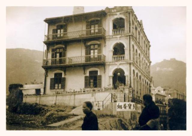
Homeville, Wanchai Road
Thank you so much - super exciting to see this. It is the house built by NDYP Inspector William Lysaught, who built a number of houses of similar size and slightly smaller on Wanchai Rd. This house became his home and was where he died in June 1910. He purchased the land - I.L. 1584 in 1902 - a 5500 sq ft plot, for $5,420 and built Homeville straight away (as was required by the Crown lease). The property was left to Caroline and Margaret Lysaught, his unmarried daughters, who ran it as a boarding house - sometimes from a distance when they were 'doing the season' in Cannes (! - not bad for girls who'd started life in the Inspector's crowded couple of rooms in the Dockyard ...) Barbara Anslow mentions staying here in her recollections of her childhood in HK. As most people will know by now, more information is in my Pollicing HK - an Irish History. Do you by any chance have photos of other houses in Wanchai Rd, Herostratus? Thanks again for posting this!
Hi Patricia. i have posted
Hi Patricia. i have posted all the other photos of the area I have below. The house in the above picture is actually on IL1419 which is adjacent to IL1584 (see map below), was Homeville definitely on IL1584? The IL1584 building was directly behind this one. Below is a lot map of the area c1913.
The below is a photo taken showing the aftermath of a Typhoon c1936. The IL1584 building is at the end of the row of buildings to the right sticking out a little form the row of houses. The back of Wild Dell is on the left.
The below is a photo looking east down Wanchai road taken in the mid 1950s. The two buildings behind the tree are the two built on IL1419 (left building) and IL1584 (right building). Wild Dell is in the right foreground. All three buildings were demolished in the lat 1950s, early 1960s.
Part of the building still survives today. Between IL1584 and IL1419 was a staircase to access the IL1584 building. This still exists between King Sing Mansions and the Connaught Commercial Buildings. Here it is on Google Street View, to the left of the Seleven shopfront.
Existing staircase
On the right hand side of the
On the right hand side of the screen, upper midway down is a grey box with two darker grey squares and four grey lines. click on that and the recent images that have been uploaded should appear. Then click insert and the picture should appear in the comment.
1913 Map of Wanchai Road
Herostratus - Does your 1913 map of the Wanchai Road also show 98a? My grandfather's company, C.E. Warren & Co. was based there from 1911 onwards. It seems to have been a godown that included a "dwelling" according to the Rate Books. My father and his brothers gave it as their postal address from 1924 for some years. There's been previous correspondence about the location of this building and it would be great to see a diagram of it and of 98b, where other members of the family lived.
Jill
Homeville Wanchai Road
Thanks Herostratus -
yes I've had a rethink of this thanks to your clear map and then comparing it to other maps on Gwulo and the various Rate Book records ... My confusiion was that Lysaught owned both IL 1419 and 1584. 151 Wanchai Road - Killadoon - was thus on IL 1584 whilst 153 - Homeville was on IL 1419. Then comes 155 - Rockview and 157-9 Summersville, both owned by Nicholas Nolan (Chief interpreter supreme court) , another of 'my' Irish men, but on my side rather than the Lysaught line. Rateable values in 1912 are Killadoon $2880, Homeville $3400, Rockview $1380 and Summersville $1000 and $960. When Caroline and Margaret Lysuaght, who inherited both Homeville and Killadoon relinquished the lease in 1925 they realised $157,170. I've only got $ conversion rates up to 1919, but taking it at a cautious 3/4 or so to the dollar thats about £25,000 .... which, I'm told, is about £1.4 million now. How would that compare to current property prices, I wonder?
Where did you find the home
Where did you find the home names and owners? Rate Books? Which years? Thanks
Here is a picture taken c1930
Here is a picture taken c1930 showing the four houses along the top of the photo. From right to left is Killadoon, Homeville (a gap) Rockview (The small house with white patches on the roof) and Summersville (A semi detached building)
By 1947 (The below photo) Rockview and Summersville had gone. There was a renumbering of this part of Wanchai Road in the mid 1930s which is their likely replacement date with the row of terraced houses.
The map of 1957 shows Killadoon, numbered 185, being used as a Social Hygiene Clinic. By the early 1960s the building had gone.
Jill - In the mid 1920s 98a and 98b were renumbered 216 and 218 Wanchai Road. The 1957 map shows them above. They were located where the Lee Cheong Building is today. The size of No 216 suggests it started out as a Godown.
I’ve created places for
I’ve created places for Summersrville and Rockview. Can you suggest where to identify their location on the map using current buildings?
Wanchai Road buildings - and another question
Thank you, Herostratus. The Land Registry wasn’t able to supply me with a diagram of the Wanchai Road buildings of 1911-1923. It’s really good to see their layout. From the current street view, it’s impossible to get an idea of how things looked in the 1920s and earlier. Although the Old Boys address list of the school that the Warrens attended was still giving their address as 98a Wanchai Road in 1926, I see that C.E. Warren & Co. Ltd. announced a move to 31d Wyndham Street in 1924, so the school list was probably out of date.
I ought to put this in a separate post, but I’ve been meaning to ask you if you have a source for knock-down dates of houses, as I’ve noticed your giving these before. I’ve drawn a blank at the Land Registry for finding the precise knock-down date of my grandfather’s house that used to be 20 Broadwood Road, although, thanks to Nona Pio-Ulski's photos, I've narrowed it to about 1960.
Re: 1957 Map
Thanks for the map. As noted here with photo from 1941, the map confirms the location of the gasoline pump and the godown/working premises of C E Warren & Co. Ltd at 216 Wanchai Road.
C.E. Warren & Co. Ltd. in Wanchai Road
I had been looking again at the Harrison Forman photo cleverly unearthed by Moddsey to try to work out the position of the Warren building in relation to the petrol/gas pump. (What is the brand? - Socor?) The inscription on the Warren building reads "C.E. WARREN & CO. LIMITED. STORES AND MONUMENTAL DEPTS." The inscription for the shelter reads: "Shelter 4923. 300 Persons." Leslie Warren wound up the company in the summer of 1941. In his last letter from Hong Kong to his family on 2nd May 1941 he writes: You people must be awfully fed up with the conditions, but it looks as though you’ll have to stay in England now. I’m so sorry you are not in Australia with the Evacuées. Well, you’ll be wondering what is going to happen to me with the firm closing down. Well we gave up our Town Office two days ago & moved down to Wanchai, and, as soon as all the Stocks and Property have been sold, everything will be finished.
Re: 1941 Photo
As indicated on the 1957 Map, the petrol station was fronting Hennessy Road. I think one would be facing south looking at Wanchai Road, which is on a rise. The pump should read SOCONY - Standard Vacuum and Oil Company.
1941 photo - the end of C.E. Warren & Co. Ltd.
Thanks, moddsey. This 1941 photo marks the end of C.E. Warren & Co., which, according to its headed notepaper, started trading in 1899. I don't know of any other photos of the company's workshops or buildings, so it's wonderful that you found it.
100-108 Wanchai Road in 1910
Herostratus - I'm back on the subject of the buildings occupied by my grandfather's company, C.E. Warren & Co. at various dates. A 1910 report puts the C.E. Warren & Co. hardware factory at 100-108 Wanchai Road. Would that correspond to 220-228 on your 1957 map? The company bought 98a in 1911 and rented 98b for long duration, so that would have made sense. Grateful if you could confirm this.
Jill - 98A & 98B became 216 &
Jill - 98A & 98B became 216 & 218 in 1925 - which matches up to their location the 1957 map. In 1925 the old 98 was just to the west of Heard Street - it became (and still is) 180 Wanchai Road.
In 1925 100A B & C became 224, 226 & 228 Wanchai Road, however the original 100-110 Wanchai Road became 250-260 Wanchai Road which is a ways to the east on the other side of Tin Lok Lane, around Chi Shing Lane. The lane doesn't exist today - it is now the site of Bowrington Road Market (North Block)/Siu Fung Building on I.L 499.
Chi Shing lane can be identified today from the cut through to the market from Hennessy Road. This used to run through to Wancha Road and was called Chi Shing Lane. 100-108 was most of the property bordering Wanchai Road between Tin Lok Lane and Chi Shing Lane
Hope this helps, let me know if anything is not clear.
C.E. Warren in the Wanchai Road 1910 & in Wyndham Street 1901
Many thanks, Herostratus. That is indeed very helpful. I hoped I might have taken a photo of the relevant page for 100-108 Wanchai Road in the old Rate Books, but no. I also forgot that there was a 98c and a 98d.
Having never lived in Hong Kong, my sense of the city's geography, ancient or modern, is frail. My short visits have mostly been spent in the PRO. I need to get to grips with David's historic maps. Do you have a rough idea of the square footage that the old 100-108 Wanchai Road would have covered? I will look up Tin Lok Lane and Chi Shing Lane - most grateful for your prompt answer.
PS A couple of days ago I posted a question about my grandfather's first showroom, described in his 1901 ad as in the building opposite the Club Germania in Wyndham Street. Would there be a record of what that was? He doesn't give a number in the Jurors List. From the early picture of the Club Germania the buildings in Wyndham Street look quite impressive.
I don't have a square footage
I don't have a square footage for the site, however the 1900 map does show the outline of a large building on the approximate site which could very well be the factory mentioned in the 1910
I didn't see your question on the showroom anywhere but I created a place for the building opposite Club Germania that hosted the showroom, including photos c1900 here.
C.E. Warren & Co. tile factory site 1910 + showroom in 1901
The large outline on Ting Lok Lane certainly looks a likely candidate for the C.E. Warren 1910 factory site. Thank you!
The image of the CEW ad at https://gwulo.com/atom/37218 probably wasn't the best way of presenting my question about the address of the showroom. David has kindly anwered today. Meanwhile I have found a reference to the Phoenix Club in a link to a book uploaded by annelise. The Phoenix Club is described as being opposite the Club Germania at about the right date - I wonder if that could be a good bet. eBook - read the original - Twentieth Century Impressions of Hongkong, Shanghai, and other Treaty Ports of China - published 1908 p. 173
funeral home
On Herostratus's comment:
The 1955 picture looking east down Wanchai road is interesting. There was a funeral procession going on. Looking down the road at the left hand side and the eastmost spot, there are two buildings. The taller one looks like a residential building. And the shorter white one. Is it the Hong Kong funeral home which was there from 1930s to 1967? It is now the Lee Cheong building.
By the way, at the junction with Heard street, there is a sign on the right hand side "tiger newspaper" meaning "Hong Kong Standard" in English. Its address should be 179 Wanchai road. Of course there are the two buildings at the junction with Wood Road Herostratus mentioned. Therefore it is very likely the short white building is the funeral home.
Just found this photo on Uwants which shows the closeup front view of the funeral home. On the left there was a flower shop. Behind the flower shop was a petrol station on Hennessy road which became a truck parking lot between 1960s and 1974. Between the funeral home and the flower shop, there was a staircase going down to Hennessy road. The parking lot is today a basketball court. The 1957年香港年鑑 shows the addresses of the two buildings: According to the 1957 map above, the funeral home should be at the Warren company site. The company was supposed to be there at least till 1940. But the funeral home also claimed it was there already in the 1930s. A bit of contradiction.
Another source mentioned the funeral home started out in the 1930s on Tak Yan Street on the opposite side of the street as a temporary bamboo structure. It is possible that it moved to 216 Wanchai Road after the Warren Co closed down.
http://www.givegift.com.hk/shop/zh-hans/s/exhibit_address_page/18
=========================================
========================================================
============================================================
It may be interesting to look at Hennessy road behind the funeral home. This photo is from WeShare. The gap behind the tram was occupied by the petrol stations. The sign with white characters and orange background "永興隆...." is position of a grocery store. Besides the store, there was a staircase going up to Wanchai road where the funeral home was located.
1920s Wanchai Road
With the revival of interest in Wanchai Road on the funeral home etc, a similar scene below of a funeral procession.
precious blood primary school
This building was used as a girl school from 1945 to 1954.
It was called Tack Ching Girls' Secondary School then. (德貞第二女子中學)
Now it is a primary schools with both boys and girls called "precious blood primary school or 寶血小學 located in Happy valley.
http://www.preciousbloodhv.edu.hk/tc/school.php?id=9
staircase
A better view of the staircase between Connaught Commericial building (185 Wanchai rd) and King Sing Mansion (187 Wanchai rd) mentioned above