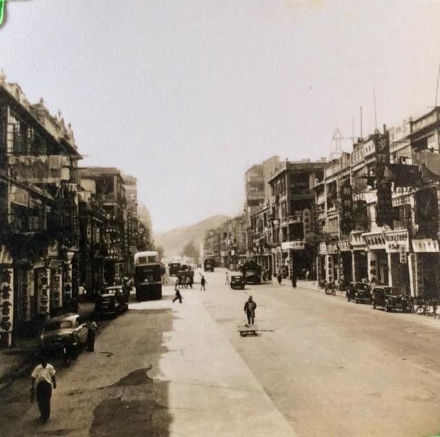
Greetings. Wide road, double decker bus, pre-WWII buildings, this might have been taken from a bus going northwest on Cheung Sha Wan Road just passed Maple Street playground. There was a bookstore on the far left but its name does not ring a bell. In those days, Cheung Sha Wan Road traffic terminated at Yen Chow Street with two large metal gates. Beyond the gates were two trees which could be the same in this photo, and farther up no more pre-war buildings. Distance from here to Yen Chow Street is about right, almost certain Cheung Sha Wan Road if the bus can be confirmed Route #4.
The second shop on the right hand side of the photo is a shoe retail shop that is still in operation today. According to the shop keeper, this shop was in operation from the mid 20s to 1970, whereas the back of the shop was also a factory from the mid 20s to late 30s. From other confirmed sources, the address of this shop is 302-304 Lai Chi Kok Road, the shop keeper also confirmed that despite there are two numbers in the address, it is of a single shop front. The shop on the left "新時代" is a photography studio located on the 1/F.
Greetings, and thanks Trav for identifying the location.
My original estimate was Lai Chi Kok Road given its multitude of shops and more/bigger vertical signs compared to Cheung Sha Wan Rd.
Next, two features in the photo changed my mind. There was a book store on the south side of Cheung Sha Wan Road just west of the playground with its location matching well with the one in this photo. Also, there were two trees on the other side of Yen Chow Street. They stood on the ground higher than the road as if years ago someone placed a pile of soil there.
According to your information, the bus in this photo would be Route #2 which started at TST and terminated at the corner of Yen Chow St and Lai Chi Kok Road. There were typically one or more buses waiting at the corner visible from this vantage point. Another bus line was #12 (between Jordan ferry and Lai Yuen. Note that this photo shows the distant ridgeline sloping downward from right to left.
This photo - https://gwulo.com/atom/28814 - taken from Lai Chi Kok Road about the same distant from Yen Chow St., shows the ridgeline sloping downward from left to right. Would a small change in vantage point result in this difference given that the road is straight?
Both ridgelines are atop of today's St. Raphael Cemetary, and since the two roads are parallel, the Cheung Sha Wan Road shows its northern portion.
Coincidentally I was on Cheung Sha Wan Road earlier today and it still benefits from seeing some of the distant ridgelines (albeit between buildings) and it looks to be slightly further to the right of the above view, so I think this most likely is lai Chi Kok Road. Unfortunately, Lai Chi Kok Road's view to the hills is now completely obscured by high rises so a definitive view is not possible.
With reagrds to the link you just posted, there is something not quite right about the picture and it's a combination of the complete lack of hills in the background (just a slope going the wrong) coupled with the shophouses looking not quite the same. The ones in that old photo seem to have taller columns compared to the upper floors whereas the one still standing seems to have much more squat ones by comparison. Just an opinion anyway, but it makes me wonder if perhaps the original creator of that comparison had correctly identified Lai Chi Kok Road - or at least the direction we are looking?
Hi Phil, thank you for the feedback. Nothing beats an on-site investigation by a local citizen.
The hill in this photo, slightly to the right/north from the road's alignment, could be the peak with elevation 149 metres on this 1952 map - https://gwulo.com/jubilee-buildings?a=1#15/22.3411/114.1475/Map_by_ESRI…; . This places the location at Lai Chi Kok Road. The view from Cheung Sha Wan Road would be its northern slope.
Regarding the old and new photo comparison, I think they are showing the same shophouse (location arrow corrected on that page). The upper/old photo shows it and adjacent flats having about the same height clearance; if there were differences, ground level appears about one foot higher. The Google street view shows there is a pipe (downspout) and a decorative panel attached to the columns, resulting in a different perspective I guess. I think if we walk up the road another two blocks, we should be able to see the same 149-metre peak, in those early years of course.
Now, the two trees, they could be those just west of the police station.
Perhaps one is looking at Nathan Road southbound. Not clear, but I think there is a pai lau (for the visit by the Duke of Edinburgh) further up on the road on the right. Guessing near the Alhambra Theatre. The hill (???) on the left may be the Nathan Road and Gascoigne Road intersection.
Greetings, and valuable discussions, thanks folks. The white outline at the end of the street, just before the tree, could be a part of the police station, similar height as the adjacent 3-level shophouses. I saw these vertical shop signs in the 1950s, but after so many years, I cannot be sure of their location, Regards, Peter
I have take a closer look at the Lai Chi Kok Road in the 1930s photo and have highlighted some of my observations in another photo file uploaded herewith, the observations include:
1. there appears to be fewer or more houses from 264 Lai Chi Kok Road towards Nam Cheong Street (main street) intersection;
2. there appears to be 2 intersections very close together along this section of Lai Chi Kok Road (perhaps one is a main street and another one is a service lane between houses)
Thanks moddsey for the photo and suggestion. I agree the hill in the middle is most likely the same as that in the page-top photo.
Thanks Trav also for your investigation. I believe there was once a service lane between the Nam Cheong corner flats and the surviving shophouse, with the latter counting second from the lane. This lane no longer exists, but the lane on the opposite/south side is still there.
moddsey, your photo appears to show the water's edge. If true, Lai Chi Kok Road is three short blocks up on the 1952 map. On the screen showing the 1952 map, extend Lai Chi Kok Road with a ruler, for the cameraman on the western portion of Lai Chi Kok Road, the "middle" hill should be visible off by a bit to the right of the street alignment.
This could be the source of my original confusion. In the page-top photo, the camera's view was aligned with the road. However, since it was taken from the south side of the road and about 10 feet (3 metres) above ground, it was able to capture more scenery to the north including the peak discussed above. The 1930s photo, taken at street standing level and closer to road's midpoint, missed the peak due to obstructions; so it captured more of the southern slope of the same peak. Does this this sense?
Greetings and thank you Trav for comparing the past structual changes to the buildings blocks at Lai Chi Kok Road and Nam Cheong Street.
The original pre-WWII shophouses typically have one staircase serving two columns of flats. If the number is odd, then one of the corner units has its own staircase. Re-developments often proceed in pairs but here is one interesting exception.
When looking at your Intersection Line 2, the northeast corner block west of the service lane had four columns, hence possibly 3 units. The middle space might have been a part of the corner unit, but this needs to be verified. Currently, there are 2 columns of flats at the corner - 270 and 272 in your photo (thanks). So, one would expect that they maintained the original width up to the lane, but it appears not so.
Although the service lane is gone, its location should align with that on the south side. Using Google street views, I estimate it to be between the current 266 and 268 flats, slightly more on the 266 side. So, the current set up has three addresses west of the lane. Given these units were not re-developed at the same time, it is puzzling how they did it.
As for the surviving shophouse, I estimated it was second from the lane according to the discussion above. Regards, Peter
Many thanks to all your collective efforts to identify the location of this photo [taken between march -july- 1957], will now add this location to photo in my album. With a magnifying glass I am able clearly to read these words written along the bottom of the long vertical banner of Chinese characters directly above the first car on right hand side of photo.
PO SHING
S--- CO LTD.
The number on bus not able to identify
While in Command Workshops I was for a time assigned to Refrigeration repair workshop and would escort the Chinese foreman and one of his workforce when collecting spares from stores/shops needed as replacments. Never knew the camp was built on reclaimed land and found the old photos produced most interesting, Thankyou Bryan.
Greetings Bryan. I thank you too for posting the photo. Over time, details got distorted or forgotten. From these discussions, I can equate what I saw decades ago to a specific street. Looking at it now is more enjoying because you were standing, more likely riding on the upper decker, three blocks from my former residence. Regards, Peter
My 94 year old father used to live in a shop house at the corner of Un Chau Street and Pei Ho Street before the war. As third national he escaped to China to try and contact his family in Peru but his brother remained in HK. I would be very interested in any old photos of the house he used to live in and it would make him extremely happy to see it again. I visited the street corner last year but could not identify anything which might have been "his" shop house.
Any help with this and with finding my uncle's grave would be much appreciated. He died during the Japanese occupation but although I have been to both Cheungshawan and Happy Valley cemetries to look for documentation I was unable to find any. Thanks in advance
Comments
Sham Shui Po - estimated location
Greetings. Wide road, double decker bus, pre-WWII buildings, this might have been taken from a bus going northwest on Cheung Sha Wan Road just passed Maple Street playground. There was a bookstore on the far left but its name does not ring a bell. In those days, Cheung Sha Wan Road traffic terminated at Yen Chow Street with two large metal gates. Beyond the gates were two trees which could be the same in this photo, and farther up no more pre-war buildings. Distance from here to Yen Chow Street is about right, almost certain Cheung Sha Wan Road if the bus can be confirmed Route #4.
Location Update
The second shop on the right hand side of the photo is a shoe retail shop that is still in operation today. According to the shop keeper, this shop was in operation from the mid 20s to 1970, whereas the back of the shop was also a factory from the mid 20s to late 30s. From other confirmed sources, the address of this shop is 302-304 Lai Chi Kok Road, the shop keeper also confirmed that despite there are two numbers in the address, it is of a single shop front. The shop on the left "新時代" is a photography studio located on the 1/F.
Sham Shui Po - view from road/bus
Greetings, and thanks Trav for identifying the location.
My original estimate was Lai Chi Kok Road given its multitude of shops and more/bigger vertical signs compared to Cheung Sha Wan Rd.
Next, two features in the photo changed my mind. There was a book store on the south side of Cheung Sha Wan Road just west of the playground with its location matching well with the one in this photo. Also, there were two trees on the other side of Yen Chow Street. They stood on the ground higher than the road as if years ago someone placed a pile of soil there.
According to your information, the bus in this photo would be Route #2 which started at TST and terminated at the corner of Yen Chow St and Lai Chi Kok Road. There were typically one or more buses waiting at the corner visible from this vantage point. Another bus line was #12 (between Jordan ferry and Lai Yuen. Note that this photo shows the distant ridgeline sloping downward from right to left.
This photo - https://gwulo.com/atom/28814 - taken from Lai Chi Kok Road about the same distant from Yen Chow St., shows the ridgeline sloping downward from left to right. Would a small change in vantage point result in this difference given that the road is straight?
Both ridgelines are atop of today's St. Raphael Cemetary, and since the two roads are parallel, the Cheung Sha Wan Road shows its northern portion.
Regards, Peter
Photo
Hi Peter.
Coincidentally I was on Cheung Sha Wan Road earlier today and it still benefits from seeing some of the distant ridgelines (albeit between buildings) and it looks to be slightly further to the right of the above view, so I think this most likely is lai Chi Kok Road. Unfortunately, Lai Chi Kok Road's view to the hills is now completely obscured by high rises so a definitive view is not possible.
With reagrds to the link you just posted, there is something not quite right about the picture and it's a combination of the complete lack of hills in the background (just a slope going the wrong) coupled with the shophouses looking not quite the same. The ones in that old photo seem to have taller columns compared to the upper floors whereas the one still standing seems to have much more squat ones by comparison. Just an opinion anyway, but it makes me wonder if perhaps the original creator of that comparison had correctly identified Lai Chi Kok Road - or at least the direction we are looking?
Just my 2 cents anyway.
Phil
Sham Shui Po - Identifying Street
Hi Phil, thank you for the feedback. Nothing beats an on-site investigation by a local citizen.
The hill in this photo, slightly to the right/north from the road's alignment, could be the peak with elevation 149 metres on this 1952 map - https://gwulo.com/jubilee-buildings?a=1#15/22.3411/114.1475/Map_by_ESRI…; . This places the location at Lai Chi Kok Road. The view from Cheung Sha Wan Road would be its northern slope.
Regarding the old and new photo comparison, I think they are showing the same shophouse (location arrow corrected on that page). The upper/old photo shows it and adjacent flats having about the same height clearance; if there were differences, ground level appears about one foot higher. The Google street view shows there is a pipe (downspout) and a decorative panel attached to the columns, resulting in a different perspective I guess. I think if we walk up the road another two blocks, we should be able to see the same 149-metre peak, in those early years of course.
Now, the two trees, they could be those just west of the police station.
Again, many thanks for your help.
Regards, Peter
Lai Chi Kok Road in the 1930s
background
I guess it's possible the hills are obscured by mist? But does anyone know what that slope would correspond to - part of the camp?
Observations
Perhaps one is looking at Nathan Road southbound. Not clear, but I think there is a pai lau (for the visit by the Duke of Edinburgh) further up on the road on the right. Guessing near the Alhambra Theatre. The hill (???) on the left may be the Nathan Road and Gascoigne Road intersection.
Sham Shui Po - Identifying Street
Greetings, and valuable discussions, thanks folks. The white outline at the end of the street, just before the tree, could be a part of the police station, similar height as the adjacent 3-level shophouses. I saw these vertical shop signs in the 1950s, but after so many years, I cannot be sure of their location, Regards, Peter
Hills near Sham Shui Po
Not sure of the Lai Chi Kok Road alignment with reference to the hills below. May be the hill in the middle.
Further Observations
I have take a closer look at the Lai Chi Kok Road in the 1930s photo and have highlighted some of my observations in another photo file uploaded herewith, the observations include:
1. there appears to be fewer or more houses from 264 Lai Chi Kok Road towards Nam Cheong Street (main street) intersection;
2. there appears to be 2 intersections very close together along this section of Lai Chi Kok Road (perhaps one is a main street and another one is a service lane between houses)
Sham Shui Po - identifying street
Thanks moddsey for the photo and suggestion. I agree the hill in the middle is most likely the same as that in the page-top photo.
Thanks Trav also for your investigation. I believe there was once a service lane between the Nam Cheong corner flats and the surviving shophouse, with the latter counting second from the lane. This lane no longer exists, but the lane on the opposite/south side is still there.
moddsey, your photo appears to show the water's edge. If true, Lai Chi Kok Road is three short blocks up on the 1952 map. On the screen showing the 1952 map, extend Lai Chi Kok Road with a ruler, for the cameraman on the western portion of Lai Chi Kok Road, the "middle" hill should be visible off by a bit to the right of the street alignment.
This could be the source of my original confusion. In the page-top photo, the camera's view was aligned with the road. However, since it was taken from the south side of the road and about 10 feet (3 metres) above ground, it was able to capture more scenery to the north including the peak discussed above. The 1930s photo, taken at street standing level and closer to road's midpoint, missed the peak due to obstructions; so it captured more of the southern slope of the same peak. Does this this sense?
Regards, Peter
Lai Chi Kok and Nam Cheong Junction
Greetings and thank you Trav for comparing the past structual changes to the buildings blocks at Lai Chi Kok Road and Nam Cheong Street.
The original pre-WWII shophouses typically have one staircase serving two columns of flats. If the number is odd, then one of the corner units has its own staircase. Re-developments often proceed in pairs but here is one interesting exception.
When looking at your Intersection Line 2, the northeast corner block west of the service lane had four columns, hence possibly 3 units. The middle space might have been a part of the corner unit, but this needs to be verified. Currently, there are 2 columns of flats at the corner - 270 and 272 in your photo (thanks). So, one would expect that they maintained the original width up to the lane, but it appears not so.
Although the service lane is gone, its location should align with that on the south side. Using Google street views, I estimate it to be between the current 266 and 268 flats, slightly more on the 266 side. So, the current set up has three addresses west of the lane. Given these units were not re-developed at the same time, it is puzzling how they did it.
As for the surviving shophouse, I estimated it was second from the lane according to the discussion above. Regards, Peter
1930s Sham Shui Po Barracks - Lai Chi Kok Road
Lai Chi Kok Road
Impressive and conclusive! For you and for this photo, respectively. Regards, Peter
Sham Shui Po
Many thanks to all your collective efforts to identify the location of this photo [taken between march -july- 1957], will now add this location to photo in my album. With a magnifying glass I am able clearly to read these words written along the bottom of the long vertical banner of Chinese characters directly above the first car on right hand side of photo.
PO SHING
S--- CO LTD.
The number on bus not able to identify
While in Command Workshops I was for a time assigned to Refrigeration repair workshop and would escort the Chinese foreman and one of his workforce when collecting spares from stores/shops needed as replacments. Never knew the camp was built on reclaimed land and found the old photos produced most interesting, Thankyou Bryan.
Sham Shui Po - identifying street
Greetings Bryan. I thank you too for posting the photo. Over time, details got distorted or forgotten. From these discussions, I can equate what I saw decades ago to a specific street. Looking at it now is more enjoying because you were standing, more likely riding on the upper decker, three blocks from my former residence. Regards, Peter
Un Chau St Shop Houses
My 94 year old father used to live in a shop house at the corner of Un Chau Street and Pei Ho Street before the war. As third national he escaped to China to try and contact his family in Peru but his brother remained in HK. I would be very interested in any old photos of the house he used to live in and it would make him extremely happy to see it again. I visited the street corner last year but could not identify anything which might have been "his" shop house.
Any help with this and with finding my uncle's grave would be much appreciated. He died during the Japanese occupation but although I have been to both Cheungshawan and Happy Valley cemetries to look for documentation I was unable to find any. Thanks in advance
Corner shophouse
Hi LR I wonder if this was the building? http://hongkongandmacaufilmstuff.blogspot.hk/2016/06/rush-hour-2-jackie… Phil