Sent to me by harrym via email. He wrote:
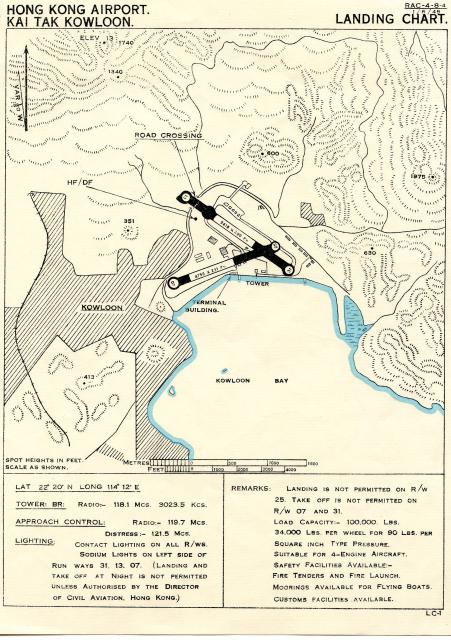
You may also be interested in the 1945/46 Kai Tak airfield information chart attached herewith which gives a good idea of the airfield’s very constricted and potentially hazardous nature, obvious from its close proximity to Lion Rock and other rather knobbly terrain! I operated from it during that period and later in the 1950s, as well as from the ‘new’ Kai Tak (opened in 1958) until my retirement from flying in 1982.
Correction of date: runway extention was made in 1950, so the date was set to 1951.
Date picture taken
1951
Gallery
Shows place(s)
Comments
Kai Tak Airfield chart
Although this landing chart is annotated 1-6-45 in the top righthand corner, it shows the runway extension crossing over the Clearwater Bay Road that was not built until 1950.
Therefore it is not a 1946 chart.
See other Kai Tak charts and images on gwulo for the same periods.
Further links
HMS Vengeance website:
As IDJ mentions, the general layout of 1945/46 Kai Tak can be viewed here showing the RN and RAF sides of the airfield. More photos here
Date of map
I contacted harrym. He replied that it's hard for him to remember what the situation exactly was in 1946, but he's now quite sure that -although the chart is generally valid - the extention was made later than 1946. He remembers to have landed in Kai Tak in 1952 (after not flying to Hong Kong for a while) and that he was happy that runway 13 was extended over the main road.
I'll amend the entry to 1951.
P.S. He added: Hope your eagle-eye friends discover no more errors!