Victoria-Harbour - map of 1866

Tue, 03/15/2016 - 14:12

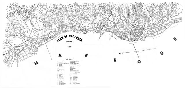
Here goes my second attempt at adding maps for David's new map project. The source this time is the 1867 edition of the Chronicle & Directory of China. Japan & Corea etc.,etc. Note that there are some minor imperfections in the street alignments in the area adjacent to Taiping Shan, Union Chapel & Hollywood Road ( marked as "37" & "D" respectively in the Index) . These errors (arising from page joints or paper folds) were present in the original microfilm reader printouts from which I have stitched this map together. Readers also note that the cartographer has not aligned this map in the conventional North facing direction.

Date picture taken
1866

Comments

Another good addition, thank you. Here's the index to help people find it when searching by text:

INDEX.

  • 1.    Government House.
  • 2.    Government Offices.
  • 3.    Cathedral.
  • 4.    Murray Barracks Officers Quarters.
  • 5.    Court house.
  • 6.    Post Office.
  • 7.    English Club.
  • 8.    Zetland Lodge.
  • 9.    St. Pauls College.
  • 10.    Gaol.
  • 11.    Victoria Library
  • 12 / 13. Murray Barracks.
  • 14.    Main Guard.
  • 15.    Parade Ground.
  • 16.    Head Quarters
  • 17.    Naval Yard
  • 18.    Arsenal
  • 19.    Commissariat.
  • 20.    Cricket Ground
  • 21    Military Hospital.
  • 22    Wellington Battery
  • 23    Gunshed
  • 24 Native Hospital
  • 25 Engine House
  • 26 Ordinance Office
  • 27    New Seamens Hospital
  • 28    East Guard House.
  • 29. New City Hall: {Public Fountain Opposite
  • 30. Clock Tower.
  • 31. Roman Catholic Church.
  • 32. Central Market.
  • 33.    P. & 0. Company’s Offices
  • 34.    Messrs Jardine, Matheson & Co.
  • 35.    Messrs Dent & Co.
  • 36. Ice House.
  • 37.    Union Chapel.
  • 38.    Mint.
  • 39.    Racecourse Grand Stand
  • 40.    Cemetaries. -  Parsee. / Protestant / Roman Catholic
  • 41.    China Mail Office
  • 42.    Daily Press Office.
  • A. A. A. Praya.
  • B  B  B. Queen's Road
  • C           Public Garden
  • D D       Hollywood Road
  • E. E.      Caine Road
  • F. F       Bonham Road.
  • G          Hospital Road
  • H           Mosque.
  • I            Mahomedan Cemetary.
  • J           Water Tank.
  • K.          Harbour Master's Office

Tymon has found this map was also used in the 1867 edition of "The Treaty Ports of China and Japan. A Complete Guide to the Open Ports of those Countries, together with Peking, Yedo, Hongkong and Macao" It has been reprinted by Cambridge Press, and they have the maps (colour, hand-tinted) available for download in their "resources" section. The Hong Kong map is "Map 003: Map of Victoria", on the second page of the resources:

http://www.cambridge.org/hk/academic/subjects/history/east-asian-histor…