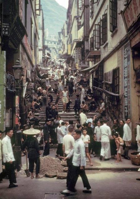
I did flip it, but some of the writting at the bottom of the street was then backwards so I think this is the correct way. Due to the slope of the hill I thought it was more in the Sands St. region.
I have an impression that Pottinger Street was (and still is) much wider and its steps were primarily made of irregular granite slaps, not those shown in the photo. The steps at Sands Street a likely even wider.
I wonder if it was one of those smaller steps uphill somewhere in Sheung Wan ......
We discussed this at length on the "Hong Kong - the Early Years" facebook page, and decided that it couldn't be Pottinger Street - for a start, there's a set of modern stairs on the right of pottinger street.
It's not Aberdeen Street, because the building on the right is similar, but has an enclosed verandah on the 2nd level.
Could it be "Ladder" street?, (although a lot of photos of "stair" streets are captioned wrongly as "ladder" street")
If the western side (West End?) is concerned, there might be a few of those steps going up between Eastern and Western Streets. Well, some of them, or what's left of it, still exist. It would be very difficult to check out the skyline nowadays though. Worth taking a look if you are in the area. It's just about two city blocks or so if you do not mind walking up and down repeatedly.
After taking a look using the Full Screen mode of Zoomify for a while I recognized there is a paint on signage on the wall saying 江蘇酒家老牌子. Looking up 江蘇酒家 using Google I found a photo (https://zh-tw.facebook.com/oldhkphoto/photos/a.408777819207446.95836.34…). According to the description in that public facebook page, the photographer was standing at around the junction of Queen's Road Central & Hiller Street, with the then Central Theatre on the Left. The neon sign of 江蘇酒家 could also be seen in the photo. The site of the Central Theatre is now Central Mansion.
I believe the paint-on signage is likely very close to the restaurant, or on the wall of the restaurant itself. That would be right around present day Ladder Street. If only we could find out when the Government build Lok Ku Road.... Maybe who has old maps and/or photos of that particular length of Queen's Road Central should have the clue of this.
The white words on the column looked like 高棧佳記自製廠. It might only be part of the signage though. If, the photo is showing the lower part of Ladder street (at present day Lok Ku Road), the YMCA building should be visible of sort. However it is very difficult to see anything similar. Anyway, with the 江蘇酒家老牌子 signage there, I believe the steps was likely somewhere along the last section of Queen's Road Central towards Sheung Wan.
I was Googling 上環江蘇酒家 and found a site with information provided by Mr Cheng Po Hung (http://www.thevoice.org.hk/thevoiceOnline/article.asp?Position=1&ToPage…) Mr Cheng's narratives mentioned the said Restaurant was in the junction of Ladder Street and Queen's Road Central. That seemed to match the photo stated in the Facebook page mentioned in a previous message, before Lok Ku Road was created.
It would seem if we could confirm the building to the right hand side of the photo was actually 江蘇酒家, that would be Ladder Street. Or, if someone has photos of the upper end of Ladder Street/Seymour Road at the same period we might be able to verify the block of older building.
There is still no proof, but I am now inclined to think the photo showed the pre Lok Ku Road Ladder Street and the original steps was a bit more narrow than the current version at Queen's Road Central. This being:
1. 江蘇酒家老牌子 sinage was very likely painted on the exterial wall of mentioned 江蘇酒家;
2. In an narrative elsewhere Mr Cheng Po Hung had stated 江蘇酒家 used to be at Ladder Street & Queen's Road Central;
3. I have been to Ladder Street earlier today. At the bottom (actually I have to walk a few steps up so the light box of Lok Cha Hin would not block my line of sight) one could not see the YMCA building as Ladder Street bent toward the west a little bit when it reached Man Mo Temple;
4. One cannot see Man Mo Temple at the bottom of Ladder Street;
5. In the original photo there was a low building (with a verenda?) at an angle to the steps. In present day the Tung Shing Terrace up in Bridges Street is also at an angle to Ladder Street;
I am uncertain when was the photo taken. I guess we now need some older photos of Man Mo Temple with the older version of Tung Shing Terrace for comparision.
I think T is right about the photo being Ladder Street looking up from Queen's Road Central. The building directly behind Man Mo Temple can be seen in the 1940s photo posted above.
In the background of Moddsey's picture is a building with the date "1929" on the top, HKMan has a really clear picture of that building, with that date on it.
Yet found another photo, also from eternal1966's Flickr collection, concerning the building behind Gung Sor (公所). The phrase Tung Wah Group of Hospitals (東華三院) was visible, but the signage was cropped. So it would seem at a certain stage that has something to do with TWGH. Yet another photo of the collection revealed another school name 聖雲仙英文書院中區分校 (St. Vincent English College Central District branch). The paint job of the outer wall looked different too.
On the next building behind it, there was a vertical sign saying 威靈頓英文書院 (Wellington English College). That was a quite famous private school.
Comments
Re Pottinger St
Looks like Pottinger St. Please see if there is a need to horizontally flip the photo when comparing it with other photos in the gallery
re Pottinger St
I did flip it, but some of the writting at the bottom of the street was then backwards so I think this is the correct way. Due to the slope of the hill I thought it was more in the Sands St. region.
Re:Pottinger St?
Hi there,
I have an impression that Pottinger Street was (and still is) much wider and its steps were primarily made of irregular granite slaps, not those shown in the photo. The steps at Sands Street a likely even wider.
I wonder if it was one of those smaller steps uphill somewhere in Sheung Wan ......
Thanks & Best Regards,
T
I agree with T that Pottinger
I agree with T that Pottinger Street is wider than this one, and Sands Street is wider still. Here are views up Pottinger Street from Queen's Road:
and from Wellington Street:
Regards, David
Not Pottinger Street
We discussed this at length on the "Hong Kong - the Early Years" facebook page, and decided that it couldn't be Pottinger Street - for a start, there's a set of modern stairs on the right of pottinger street.
It's not Aberdeen Street, because the building on the right is similar, but has an enclosed verandah on the 2nd level.
Could it be "Ladder" street?, (although a lot of photos of "stair" streets are captioned wrongly as "ladder" street")
Confused (as usual)
Alun
Central Lane
There is the same photo in Google search photos, although i have a suspicion that any street with "steps" is called a ladder.
https://www.google.com.hk/search?q=Ladder+Street+photos&biw=1366&bih=60…
Re: Central Lane
Agreed not Pottinger, Aberdeen, Ladder or Sand Streets. Interesting photo to resolve.
Re: Steps going up hill west of Hollywood Road....
Hi there,
If the western side (West End?) is concerned, there might be a few of those steps going up between Eastern and Western Streets. Well, some of them, or what's left of it, still exist. It would be very difficult to check out the skyline nowadays though. Worth taking a look if you are in the area. It's just about two city blocks or so if you do not mind walking up and down repeatedly.
My 2 cents,
T
Re: speculations......
Hi there,
After taking a look using the Full Screen mode of Zoomify for a while I recognized there is a paint on signage on the wall saying 江蘇酒家老牌子. Looking up 江蘇酒家 using Google I found a photo (https://zh-tw.facebook.com/oldhkphoto/photos/a.408777819207446.95836.34…). According to the description in that public facebook page, the photographer was standing at around the junction of Queen's Road Central & Hiller Street, with the then Central Theatre on the Left. The neon sign of 江蘇酒家 could also be seen in the photo. The site of the Central Theatre is now Central Mansion.
I believe the paint-on signage is likely very close to the restaurant, or on the wall of the restaurant itself. That would be right around present day Ladder Street. If only we could find out when the Government build Lok Ku Road.... Maybe who has old maps and/or photos of that particular length of Queen's Road Central should have the clue of this.
T
Not sure if it can help, but
Not sure if it can help, but here's a stretched view of the sign on the green pillar at the left of the photo:
Re: white words on column
Hi there,
The white words on the column looked like 高棧佳記自製廠. It might only be part of the signage though. If, the photo is showing the lower part of Ladder street (at present day Lok Ku Road), the YMCA building should be visible of sort. However it is very difficult to see anything similar. Anyway, with the 江蘇酒家老牌子 signage there, I believe the steps was likely somewhere along the last section of Queen's Road Central towards Sheung Wan.
My 2 cents,
T
上環江蘇酒家 Kiang Su Restaurant
Hi there,
I was Googling 上環江蘇酒家 and found a site with information provided by Mr Cheng Po Hung (http://www.thevoice.org.hk/thevoiceOnline/article.asp?Position=1&ToPage…) Mr Cheng's narratives mentioned the said Restaurant was in the junction of Ladder Street and Queen's Road Central. That seemed to match the photo stated in the Facebook page mentioned in a previous message, before Lok Ku Road was created.
It would seem if we could confirm the building to the right hand side of the photo was actually 江蘇酒家, that would be Ladder Street. Or, if someone has photos of the upper end of Ladder Street/Seymour Road at the same period we might be able to verify the block of older building.
My 2 cents,
T
1940s Same Street Scene
Great match on the photos. I
Great match on the photos. I've stared at them intently, but I'm still none the wiser about where we're looking at!
Regards, David
Re: speculations
Hi there,
There is still no proof, but I am now inclined to think the photo showed the pre Lok Ku Road Ladder Street and the original steps was a bit more narrow than the current version at Queen's Road Central. This being:
1. 江蘇酒家老牌子 sinage was very likely painted on the exterial wall of mentioned 江蘇酒家;
2. In an narrative elsewhere Mr Cheng Po Hung had stated 江蘇酒家 used to be at Ladder Street & Queen's Road Central;
3. I have been to Ladder Street earlier today. At the bottom (actually I have to walk a few steps up so the light box of Lok Cha Hin would not block my line of sight) one could not see the YMCA building as Ladder Street bent toward the west a little bit when it reached Man Mo Temple;
4. One cannot see Man Mo Temple at the bottom of Ladder Street;
5. In the original photo there was a low building (with a verenda?) at an angle to the steps. In present day the Tung Shing Terrace up in Bridges Street is also at an angle to Ladder Street;
I am uncertain when was the photo taken. I guess we now need some older photos of Man Mo Temple with the older version of Tung Shing Terrace for comparision.
My two cents,
T
Re: Photo Identification
I think T is right about the photo being Ladder Street looking up from Queen's Road Central. The building directly behind Man Mo Temple can be seen in the 1940s photo posted above.
Good work!
I'd never have guessed that - the bottom of ladder street looks very different today.
Regards, David
Re: Same Photo
Hi there,
Same photo already identified as Ladder Street back in 2009 by blogger Mr Anthony Lee
http://oceandeeop3000.blogspot.hk/2009/11/670-2.html
T
Man Mo Temple, Hollywood Road and Ladder Street
In the background of Moddsey's picture is a building with the date "1929" on the top, HKMan has a really clear picture of that building, with that date on it.
https://www.flickr.com/photos/old-hk/3013087224/sizes/o/
So no question, It is "Ladder Street", unlike the dozens of other pictures of "stair" streets, that are also labeled Ladder Street ;-)
Re: Building behind Gung Sor (公所)
Hi There,
Yet found another photo, also from eternal1966's Flickr collection, concerning the building behind Gung Sor (公所). The phrase Tung Wah Group of Hospitals (東華三院) was visible, but the signage was cropped. So it would seem at a certain stage that has something to do with TWGH. Yet another photo of the collection revealed another school name 聖雲仙英文書院中區分校 (St. Vincent English College Central District branch). The paint job of the outer wall looked different too.
On the next building behind it, there was a vertical sign saying 威靈頓英文書院 (Wellington English College). That was a quite famous private school.
Thanks & Best Regards,
T
Ladder Street before 1945
The main photo was taken before 1945, as the building on No. 39-49 Bridges Street (present numbering) still stood in the photo.
That building is highlighted in magenta in the collage below.
Green: Ladder Street
Orange: Bridges Street
Light blue: Hollywood Road
Yellow: Buildings on the Southeast of Bridges St / Ladder St Junction
Comparing photos taken before and after WW2, the building was destroyed in the war and site left empty in 1945 and 1949 LD photos.
In early 1950’s, No. 39-49 Bridges Street became Wellington College, then a few other schools afterwards.
So the main photo was taken before 1945.