Over on Flickr, poster eternal1966 asked if anyone knew the name of the street running along the side of the nullah (drainage channel). Here are some maps of the area, to see if they help answer the question.
The first map below is dated 1924. The area on the right of the map is marked out with a grid of streets, but to the bottom left of the grid there's a street pointing to 11 o'clock. If you click the map and zoom in, you'll see it's actually a pair of parallel streets with a nullah between them - the same one shown in the photo above. Unfortunately the name of the street isn't shown.

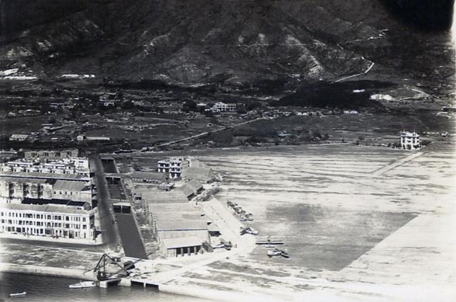
Moving ahead to this 1930 map, we can see it matches the view shown in the photo. The grid of streets never happened, and instead the area has become the Kai Tak Airfield.

This 1944 aerial reconnaissance photo shows the airport has been expanded. This was one of the projects undertaken by the Japanese during their occupation of Hong Kong. The houses along the nullah were demolished as part of that work. So, by this time the street shown in the photo had already gone, and apparently the nullah had too.

But as this later map from 1957 shows, the nullah is still there, it just doesn't show up in the 1944 photo :

Finally, this recent aerial view shows the nullah is still there today. It's had a new curved section added at the bottom, where the shoreline was reclaimed. But the previous section still follows much the same route as it did in the 1930s photo shown above.

So, no luck finding out the name of that street, but we do know where it ran, and that it is long gone. And fortunately a couple of readers have been able to tell us a lot more about what's shown in the photo. Reader IDJ first:
The multi-storey building at the right-centre was known as Field Cottage and used by the aviation club as a clubhouse. The remains of the original estate's road layout [see 1924 map] can be seen leading up to it. The hangars in the foreground were the RAF's, built as bamboo matsheds, they suffered a number of fires which periodically destroyed them:

The crane at the waterfront was used to lift aeroplanes on floats from the water onto the land for maintenance. These aircraft were based on Royal Navy ships of the "China Station" Fleet.
Reader moddsey adds:
My record for another matshed (hangar) fire at RAF Kai Tak is 16 November 1927 (see article). The fire at Kai Tak on 15 December 1931 in IDJ's photo was more serious with two matshed hangars and a Flight Office burnt down.

And a 1927 photo of 'Field Cottage' on the Kai Tak Bund:

Thanks to them for their input. Can you tell us any more? If yes, please leave a comment below.
Regards, David
PS Further reading:
- More history of Kai Tak
- Details of the old hangar, that still stands today at Diamond Hill. (It's indicated by the red arrow on the maps above)
Source: This image came from Flickr, see https://flickr.com/photo.gne?id=5346165634
Comments
1930s Kai Tak Airport
On a map originally drawn in 1939 but including amendments until 1941 which shows the No.1 Nullah area and estate at Kai Tak, the road running alongside the nullah was called Sam Tak Road. Three roads leading off it parallel with the waterfront are named as, Kai Yee Road, Cheung On Street and Kai Yan Road. The other ends of these streets lead onto Sai Kung Road. The streets going down to the waterfront are not named on this map. Each of the Kai Tak nullahs were numbered as and when they were constructed.
However, a 1942 map drawn by hand of the same area does not name the above streets, but does name four of the streets leading down to the waterfront as, Sa Po Road, Po Kang Road, Da Ko Ling Road and South Wall Road. All shown as leading off Prince Edward Road which is named as such.
Interestingly, Sa Po Road and South Wall Road still exist today opposite the demolished Kai Tak Passenger Terminal site. The other two named roads appear to have been renamed. Presumably South Wall Road as the only English name then and now was named after the old Kowloon City southern boundary?
An layered constant scale map would be useful of this area to see the year by year developments, which were considerable.
Re: 1930s Kai Tak Airfield
This is the closest ground level photo of the junction of Sai Kung Road (today's Prince Edward Road East) and Sam Tack Road (adjacent to the nullah). Note the Field Cottage in the distance.