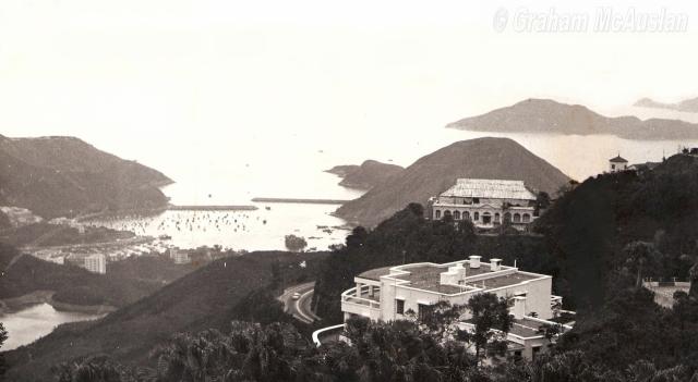
I believe Aberdeen Dockyard is not vsible in the photo at all. The embankments shown are the eastern entrance of the Aberdeen Shelter with Apleichau by the right.. The dock should have been obscured by the hill in the foreground.
The rocky shore by the left wth lots of berthing boats would have been Sham Wan. I have found an approximate position with a similar view in street view. You might have to zoom in.
Thanks, T, for your comment, you are spot on. What I should have named as visible was the Aberdeen Harbour Typhoon Shelter.
Thanks for the matching current day view from Google Maps Street View. Do you know if it would be legal from a copyright perspective to "screen capture" that street view and post it here. Do you reckon that would be "Fair Use"?
I will remove the reference to the Dockyard being visible.
Thanks Admin (David or T, I'm guessing). That imbedding is a great feature Google facilitates, and it certainly avoids any copyright issues I imagine.
The view shown in the current day Street View is very similar to the one all the residents on Mt Gough enjoyed every day to the south over Aberdeen reservoirs and the Typhoon Shelter back when I lived at Clavadel on Gough Hill Road over 40 years ago. Of course there are many more tall buildings down there beyond the reservoir now than there were back then!
You're welcome. Unfortunately I haven't found a way to add in Street View without using Admin rights - it would be much better if everyone could add it.
T did well to match up the view. The roadsides today are a lot more overgrown than in the old photos, so in Streetview there's often a tree in the way!
Comments
Re: Chief Justice's House (Lysholt) 18 Gough Hill Road The Peak
Hi there,
I believe Aberdeen Dockyard is not vsible in the photo at all. The embankments shown are the eastern entrance of the Aberdeen Shelter with Apleichau by the right.. The dock should have been obscured by the hill in the foreground.
The rocky shore by the left wth lots of berthing boats would have been Sham Wan. I have found an approximate position with a similar view in street view. You might have to zoom in.
Best Regards,
T
Yes, you are correct re Aberdeen Dockyard....
Thanks, T, for your comment, you are spot on. What I should have named as visible was the Aberdeen Harbour Typhoon Shelter.
Thanks for the matching current day view from Google Maps Street View. Do you know if it would be legal from a copyright perspective to "screen capture" that street view and post it here. Do you reckon that would be "Fair Use"?
I will remove the reference to the Dockyard being visible.
Thanks and Cheers, Graham,.
Google's view
View Larger Map
Excellent! - Imbedded Google Maps Street View...Thanks, Admin
Thanks Admin (David or T, I'm guessing). That imbedding is a great feature Google facilitates, and it certainly avoids any copyright issues I imagine.
The view shown in the current day Street View is very similar to the one all the residents on Mt Gough enjoyed every day to the south over Aberdeen reservoirs and the Typhoon Shelter back when I lived at Clavadel on Gough Hill Road over 40 years ago. Of course there are many more tall buildings down there beyond the reservoir now than there were back then!
Street View
You're welcome. Unfortunately I haven't found a way to add in Street View without using Admin rights - it would be much better if everyone could add it.
T did well to match up the view. The roadsides today are a lot more overgrown than in the old photos, so in Streetview there's often a tree in the way!
Regards, David