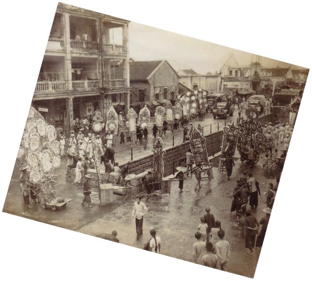
Photo courtesy of reader Geoffrey:
This pic is surreal. Could not possibly imagine all these walking wreaths and two congregations of marching bands taking up the whole road for a funeral possession. And what about that stone wall in the middle - what purpose does it serve? Have absolutely no clue about the location once again.
Date picture taken
1947
Gallery
Shows place(s)
Comments
A nullah somewhere
Hi there,
That was a typical nullah somewhere. The exact location could be difficult.
However there is a funeral parlour in Tai Kok Tsui that might have dated back to the 1940's and there was a nullah close by. Part of that stream still exist today, which runs near the railroad/Mongkok Stadium towards the shoreline in a fairly straight line. Along it's route today there is a short street between Prince Edward Road and Nathan Road called 'Nullah Road'. The side street is very easy to locate as there are a few gasoline stations there. The Nullah had gone underground though.
Best Regards,
T
Kowloon Funeral Parlour
Hi there,
Just checked and according to Wiki this Funeral Parlour only dated back to the 1950's, so the Nullahs nearly might not have much to do with the one in the photo. The homepage of the Parlour does not provide any information concerning their historical background.
Gotta have some cross references using other old Hong Kong photo albums in the market for comparison. I remember I have browse some of those by famous photographers which also have some funeral march photo in them.
Best Regards,
T
Nullahs near Temple Street
Any idea how far the procession would travel? Would it just do a circuit in the area, or make a longer journey?
Looking on the 1947 map of Kowloon, there are several roads in the area with nullahs. They all had covered sections like the photo above, usually where side streets would need to cross over the nullah :
Could it be any of those?
I also had a message by email suggesting another couple of nullahs in Kowloon, but they seem too far away?
MrB
- I saw roadworks on Waterloo Road a couple of years back, where they had dug up the center of the road outside the Fire Station, near the YWCA. You could see the stone-lined nullah looking very similar to the style of the one in the picture. So the nullahs are still there, just covered over with concrete slabs, and with a road layed on top.
- In section 7 of Paul Tsui Ka Cheung's Memoirs, he mentions the Argyle Street Nullah, as shown below. There's lots of information there about Hong Kong in the first half of the 20th Century.
Nullahs
Hi there,
The Nullahs in Waterloo Road and Nam Cheong Street then looked too wide to match the one in the old photo. At least my faint memory of the area told me that. Have to look for other old photos for comparison.
T
Questions for Geoffrey
More questions in by email:
I think the question asked above is why would the procession would make a detour at this point? In this photo they appear to have come out of a side street at the top of the photo, turned right, then walked a short way before making a u-turn at this junction. Why didn't they just come out of the side street, cross straight over the nullah and turn left?
MrB
Nullahs
Greetings:
It could be Nam Cheong Street, southwest of Lai Chi Kwok Road, looking southwest towards the sea, judging by two clues:
1. Most buildings on the southwest side of Lai Chi Kwok Road were at that time smaller than 4 storey tall.
2. The nullah (storm drainage ditch) had just about the same width opening at road surface. I remember in the early 1050s Nam Cheong Street was covered by venders stalls selling merchandise and I had an opportunity to peep down and into the ditch through a small opening at one of the stalls.
Nullahs
As far as I can remember, only Nam Cheong Street to the northeast of Lai Chi Kwok Road had its nullah occupied by merchants and their shops above it continuously almost all the way to Cheung Sar Wan Road. Though not definite, this photo appears to show these shops which would have forced the procession to make a detour.
Nullahs
A couple more observations:
So that leaves us with:
The map also shows that some of the buildings facing the nullas have alleys behind them, while others have an alley between them at right-angles to the nullah. If we say the block on the far side of the road has an alley between the three-storey building on the left and the low building on the right, that cuts out most of the Nam Cheong St options, leaving:
MrB
Located at last!
Geoffrey says that Tim Ko was able to quickly identify this photo by the pale, roofless building near the top-right corner of the photo. That is the Yau Ma Tei Theatre, which was damaged and lost its roof during WWII.
So the road with the nullah is Waterloo Road, the bridge over the nullah in the foreground is Shanghai Street, and the bridge in the distance is Reclamation Street.
Funeral procession route
If the procession came up from 40-50 Temple St. through Reclamation St. to Waterloo St., then made a right turn to Shanghai St. and made a U-turn towards Reclamation St., it would not have passed through the Portland St./Waterloo junction as shown in the photo with the street sign.
One scenario is that it went up Reclamation to Argyle, turned right to go back south on Nathan, then turned right at Waterloo and paused at Portland for photo-op before resuming. This would fit all the available photos.