Merry Christmas!
If you're celebrating Christmas, I hope the day brings you:
A present or two if you're on Santa's 'good' list, ...

something tasty, ...
- Read more about Merry Christmas!
- 1 comment
- Log in or register to post comments
Welcome to GwuloHere you'll find over 50,000 pages about old Hong Kong to explore, including over 30,000 photos. The content is added by a friendly community of people who enjoy sharing what we know about Hong Kong's history, and you are very welcome to join us. Kind regards, David P.S. To receive more old Hong Kong photos and stories, please sign up for our free weekly newsletter. |
If you're celebrating Christmas, I hope the day brings you:
A present or two if you're on Santa's 'good' list, ...
something tasty, ...
What's new and updated on the Gwulo website:
General
Update on the new Gwulo book
On Monday, Suk Woon sent over photos showing that printing was underway. Here's the printing press that would print the new Gwulo books.
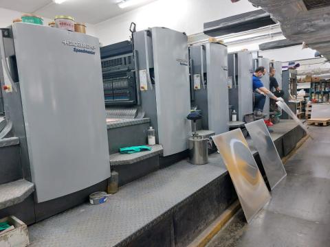
And here's one of the printing plates being mounted. There are four plates in all, one each for the cyan, magenta, yellow, and black inks (CMYK).
After mounting all the plates, the technicians can print sample sheets and make adjustments to get the best results. They check the registrations of the four colours to make sure they are all aligned, to get the sharpest final image. They also tweak the four ink levels to get the printed colours as close as possible to the proof prints we saw in the previous update.
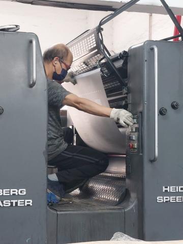
Once they are satisfied, they set the printer going. I've ordered 1,000 books, so they'll print 1,000 copies of the sheet.
The whole process is repeated another three times for the rest of the sheets that make up the book's pages, and then once more for the book's cover.
On Thursday I saw the results of their work, when Suk Woon gave me copies of all the printed sheets and the cover. Looking good!
Back at the printing company, the printed sheets were being folded, cut, and sewn into 16-page signatures. Finally they'll glue the signatures into the covers, and trim them to produce the finished books.
The latest estimate from the printer is that they will deliver the books to me on Wednesday, 20 Dec.
Thanks to everyone who has already pre-ordered the new book. If you're still planning to order, I recommend you order before Wednesday, so we can send your book(s) out as soon as the printer delivers: click here to pre-order Volume 5.
People
|
28 Dec 2023 update: The printer has delivered the new book, so the pre-order offers have now finished, and the book's price is back to the regular HK$168. Shipping remains free for all orders to a Hong Kong address, and free for orders of 2 or more copies to international addresses. The discounts for larger orders also continue, so you'll save 15% on orders for 5 or more books, and save 20% on orders for 10 or more books. Please click the links below to place your order:
|
Take advantage of these pre-order offers as we get close to the launch of the new Volume 5:
Special price
The book's list price will be HK$168, but regular readers can pre-order copies at HK$150 until 22 December.
Please click a "Pre-order ..." link below to pre-order your book(s). Payment can be made online using a credit card or a Paypal account. Readers with a bank account in Hong Kong also have the option to pay by bank transfer, or HK$ cheque.
Add other volumes
If you're missing any of the earlier volumes, you can use the links below to either buy the whole set, or to add individual volumes to your shopping cart:
Bigger orders, bigger savings
In the past I've received occasional larger orders where people buy for a group of friends, for their company's clients, and even to put a copy in each room of a boutique hotel. If you order a larger quantity of any combination of my books, you will automatically receive additional discounts, e.g.:
Free shipping
All deliveries to addresses in Hong Kong and Asia are shipped free of charge.
If you live outside of Asia, orders for two or more of any of Gwulo's books delivered to the same address are shipped free of charge. Orders for a single book pay HK$84 for shipping.
Please note the special instructions for customers in the European Union in the Q&A section below.
Signed copies
If you'd like me to sign your book(s), that's easy to arrange. Once you've completed your order you'll receive an order confirmation email. Please reply to that with a message as follows:
| If you'd like ... | you send the reply ... | and I'll write ... |
| Standard signature | Please sign | With best wishes, David |
| Standard + names | Please sign to Emma and John | To Emma and John, with best wishes, David |
| Custom message | Please sign: A gift from Ann and Charles | A gift from Ann and Charles |
Free sample
If you'd like a look inside Volume 5, please click here to download a PDF sample of pages from the book.
Q&A
Q. When will the orders be mailed out?
A. The latest news from the printer is that they will deliver 'on or before 22 December'. I've seen photos of the printing underway and it was going well, so I'm crossing my fingers the delivery will happen on the 20th instead. As soon as the books arrive, we'll get to work packing and mailing your orders.
Q. So will they arrive in time for Christmas?
A. If we can get the earlier delivery from the printer, then I expect that Hong Kong orders placed before 20 December will arrive before Christmas. Overseas orders will be sent by airmail, and so should reach you in early January.
Q. I live in the European Union. Why isn't my country listed as a shipping destination?
A. In recent years the EU countries have got much stricter about claiming VAT on books arriving from overseas. Customers have to pay VAT plus a handling charge that can be as much as, or more than, the cost of the book. If you're happy to accept that risk, please email me details of the books you'd like to order, your mailing address, and whether you prefer to pay by credit card or PayPal, and I'll arrange the order for you. Alternatively, you may prefer to wait until the books are in stock at Amazon, and order from them.
Q. Do you still use PayPal to handle credit card payments?
A. No, credit card payments are now handled by Stripe.
Q. I live overseas and don't have a Hong Kong bank account. Can I still pay by bank transfer?
A. Sorry, but no. You'd need to arrange a T.T. / wire transfer, and from past experience they have caused too many headaches.
If you have any other questions about ordering, or run into any problems, please contact me at david@gwulo.com
Regards,
David
PS If you have friends who like old Hong Kong photos but may not be subscribers to Gwulo's newsletter, please could you let them know about this offer?
December, 1941.
82 years ago, tensions were high as war with Japan grew ever more likely. On December 8th, Hong Kong's fears were confirmed when Japanese planes attacked Kai Tak, and Japanese soldiers crossed the border into the New Territories. The fighting continued until the British surrendered on Christmas Day.
The end of the fighting marked the beginning of the Japanese occupation, a time of great hardship for Hong Kong's residents. They would have to endure for three years and eight months, until the Japanese surrendered in August 1945 and Hong Kong was liberated shortly afterwards.
What was it like?
Let the people who lived through those times tell you themselves: A new cycle of Hong Kong's wartime diaries has just begun, where a daily email message from Gwulo shows you a selection of diary entries written on the same date, 82 years ago.
If you look at the diary entries from 7 Dec 1941, you'll see that on the eve of war there were still conflicting opinions: Hong Kong's soldiers were being mobilised, but Major Monro had strong doubts, "I don’t really believe that anyone thinks that it will come to anything".
To read the diary entries from December 1941 and beyond, please click here to sign up and receive them by e-mail each morning. It's free of charge, your details stay private, and you can unsubscribe at any time.
Sample extracts from the daily messages

What's new and updated on the Gwulo website:
General
Update on the new Gwulo book
Yesterday I finally signed off the proofs!
That was a great feeling, as the rounds of edits to text and photos were starting to feel like they would never end. That's been the case with each of the books, but thankfully there's always a sudden rush at the end where everything slots into place.
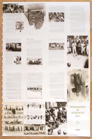
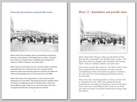
The first glimmer of hope is when I see pages with their proper layout. I create the draft document in Microsoft Word, adding in photos to show how I want the page to look. When I've finished I'm pretty happy with it, but it always surprises me how much better it looks after Lilly, the designer, turns it into the layout for the printer. Here's page 12 as an example, with my Word version on the left, and the layout from Lilly on the right.
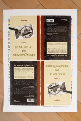
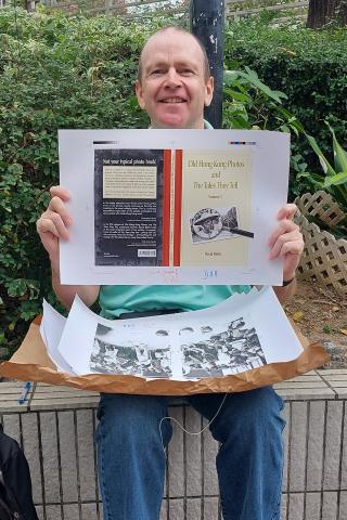
The next leap forward is when I see the cover for the first time. This is one of the last parts of the layout to be completed, so when I see this I know the end is in sight.
Once I finally decide I've run out of things to change, we ask the printer to produce a proof copy of the book. The proof copy is printed on a digital printer, so it doesn't exactly match the colours we'll get in the final offset-printed book, but it is very close. This is the first time I get to hold the book, and is always a happy moment.
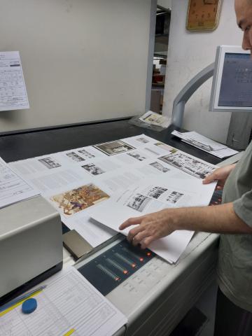
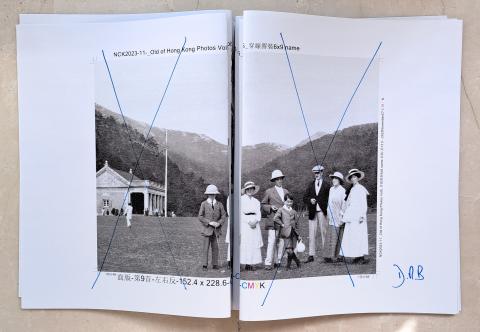
Below is the proof copy I received on Thursday. The pages are grouped into 'signatures', in this case groups of 16 pages that are printed on the same large sheet of paper, then cut and folded, and sewn together during binding. You'll see I've initialled each 16-page signature, which is the signal that I've approved the printer to go ahead with printing. BUT, you'll also note I've crossed these two pages, as I wasn't happy with the appearance of this image.
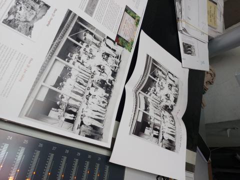
Looking through the proof copy I noted seven images I felt could be improved, which meant another late night's work in Photoshop. Lilly and Suk Woon (who works with the printing company to handle the actual printing) are both very responsive and quickly turned around my changes. Yesterday (Saturday) morning I received the new proofs for the updated pages.
The changes all looked good so I signed them all, handed them back to Suk Woon, and breathed a sigh of relief. Suk Woon takes it from here, guiding the book through the printing process.
We're nearly there! I'll let you know once I have the delivery date for the printed books.
People