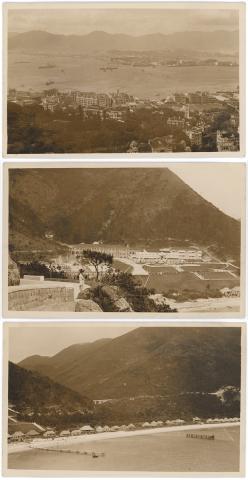
Here's another set of postcards I bought recently, this time from eBay. Like the set of four we investigated a few weeks ago, these are also Real Photo Postcards (RPPCs).
Let's see if there are any clues on the backs of the cards:
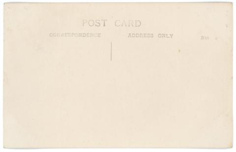
No notes from the owner, unfortunately. There is what looks like the manufacturer's code at top right where the stamp would go: "B10 3". Sometimes we can look up the manufacturer's code on the internet, and find out the range of dates when the paper was manufactured. Alas, I couldn't find any information for this one.
All three cards have this layout on the back, so they were very likely taken at around the same time, and by the same photographer. That's all I can tell from the backs though, so we'll turn them over again and see what clues the photos have for us.
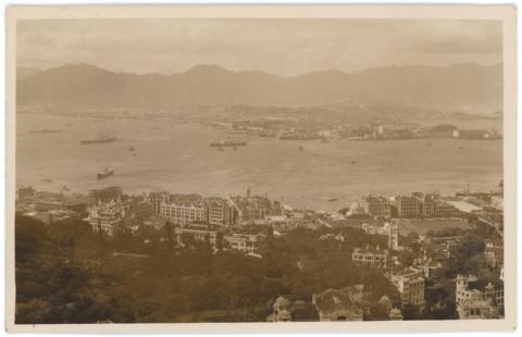
The first thing that strikes me is the
heavy colour tint. Old photos often end up with a light sepia tint, but this is much worse than usual. Maybe there was a mistake in the chemicals used during developing the prints? Never mind, Photoshop will help fix that.
What does a quick skim of the photo tell us?
- Over in Tsim Sha Tsui there's no sign of The Peninsula Hotel [1927- ], so the photo must have been taken before 1927.
- At the very bottom of the photo, just right of centre, Kingsclere / Kingsclere Hotel [c.1901-1924] is still standing, so that pushes the date back to 1924 or earlier.
- Not much earlier though. On the seafront at the left of the photo, the metal girders show the P&O building (4th generation) [1924-1961] is under construction, suggesting a date of c. 1923 for this photo.
There was a burst of construction in Central at around this time, and in particular around Pedder Street.
A building boom in Central
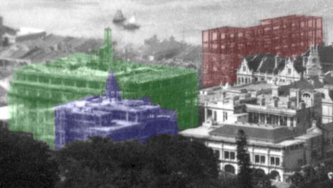
- Red: A closer view of the P&O Building, which extended from Connaught Road back to Des Voeux Road. The ornate looking building on the right of it is the older General Post Office.
- Green: On the corner of Pedder Street and Queen's Road, the new China Building (1st generation) [1924-1975] is taking shape.
- Blue: Standing on the south side of Queen's Road, the Asiatic Building / Shell House (1st generation) [1924-1958] faced into Pedder Street, so it often appears in street-level photos of the area.
All three buildings were completed in 1924 - in fact a fourth building was too: Pedder Building [1924- ]. It stood next to the China Building on the north side (the right side in the photo). I can't see any sign of it yet in this photo, so it must have sprouted up at a rapid pace to catch up with the others. It is the only one of these buildings still standing today.
The photo captures two more construction projects, a short distance to the east.
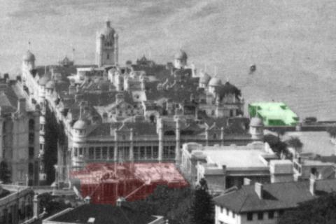
The building on the seafront with the tower in the middle is Queen's Building [1899-1961], on the site of today's Mandarin Oriental Hotel. Moving closer to the photographer we see Prince's Building (1st generation) [1904-1962], larger than Queen's Building, but built in the same style. Facing Prince's Building from across Des Voeux Road, the red highlight shows yet another building that will be finished in 1924, Bank of Canton [1924-c.1966].
Over to the right of Queen's Building, the green highlight shows Queen's Pier (1st Generation) [1925-1955]. Although it is the smallest of the construction projects, it is the one that will put a firm date on the photo. That's because the project was handled by the Government's Public Works Department, who published annual reports of progress. Their 1923 report includes these notes about the pier:
The construction of the re-inforced concrete pier and approach was completed by February.
The surfacing to the pier and approach has been suspended pending the erection of the facade to the Praya and roof to the pier.
A Contract for the construction and erection of the structural steelwork and C.I. columns for the roof was let to the Taikoo Dockyard and Engineering Co. in March.By the end of the year, the standards and trusses complete, were in position and only required painting.
That confirms the photo was taken in 1923, some time between finishing the construction of the pier in February, and erecting the structural steelwork later in the year. These photos are 100 years old!
Repulse Bay, beach, and hotel
The other two photos show Repulse Bay.
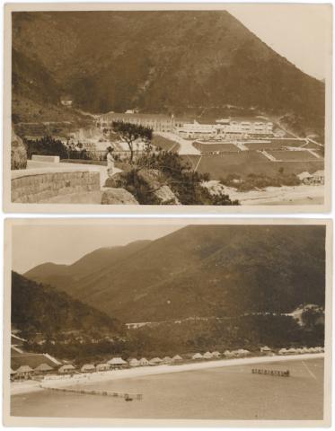
I bought them hoping the photographer had taken both from the same spot, so that I'd be able to use my computer to stitch them together. Happily that worked out well, giving us this panorama of Repulse Bay in 1923.
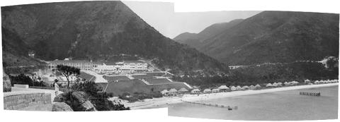
On the left we have The Repulse Bay Hotel [1920-1982], with its various outbuildings and the large Repulse Bay Hotel garage [1921- ] seen behind the man and the tree in the foreground.
The hotel overlooks the main road, where there is a line of cars parked.
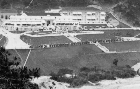
By the 1920s, Hong Kong's wealthier residents had taken to owning a motor car, but didn't have many options for where to drive it. The new road along the south of the island gave them a new route, and the hotel and beach gave them the destination, making the trip to Repulse Bay a popular outing. (I wonder how many private cars were owned in Hong Kong in 1923, and what proportion of them were here in Repulse Bay when this photo was taken!)
The right half of the panorama captures the sea and the beach:
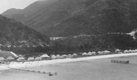
There are two piers visible. The closer one is for people visiting on launches. Launches were the main way to get to Repulse Bay before the road was built, and were still a popular option in the 1920s. The pier let you get from launch to land without getting your feet wet. The far pier involved getting a lot more more than your feet wet! It was for swimmers who wanted to dive into the sea.
Along the back of the beach is a line of beach huts, available to rent, then above that we can see the new road where it runs along the hillside.
Further reading:
If you've got Volume 3 of my books, Photo 8 gives a close-up view of the finished Queen's Pier, and Photo 20 shows Repulse Bay at about the same time the above photos were taken, but from the hotel looking out to sea.
In Volume 4, Photo 10 shows Pedder Street in 1925, after all the 1923 construction projects were finished.