From the "Albany Nullah" (which is now under Garden Road and Cotton Tree Drive) to the "Gleanealy Nullah" and Queen's Road Central.
Learn more at http://www.governmenthill.org

[gmap polygon=22.279353526913194,114.16274499875726 + 22.277645919447625,114.16034173947992 + 22.277328222735054,114.15862512571039 + 22.27693110082949,114.157294750039 + 22.276335415856938,114.15523481351556 + 22.277328222735054,114.15489149076166 + 22.27792390347912,114.1534752844018 + 22.27907554572337,114.15463399869623 + 22.280147755839376,114.15536355954828 + 22.28046544614682,114.15609312040033 + 22.279274103772483,114.15677976590814 + 22.28022717848391,114.15772390348138 + 22.279830064810202,114.15978384000482 + 22.279353526913194,114.16274499875726 |zoom=16 |center=22.278910742570872,114.15794849395752 |width=480px |height=350px |control=Small |type=Map]
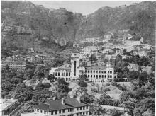
Photos that show this Place