Monday 26 October 26
丙午馬年九月十七
Happy to have found a copy of Yue Daji (粤大記), or the "Grand Record of Guangdong".
It is a late-Ming dynasty historical gazetteer compiled by Guo Fei (郭棐) between 1577 and 1595.
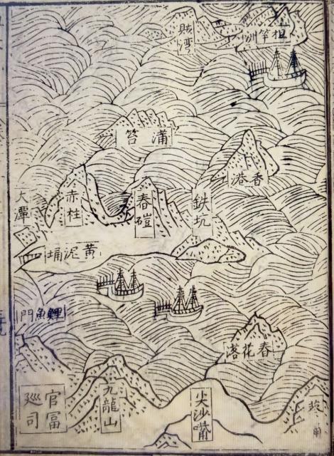
Its Coastal Map of Guangdong (廣東沿海圖) features the earliest known written record of the name "Hong Kong" (香港).
See attached map.
Paul Tsang
26 10 26
island
From the map, it looks like 香港 was perhaps the name for Ap Lei Chau, or some other island off the south coast?
關於「明代《粵大記》中的香港是指現在的鴨脷洲(或香港仔…
在地理上,正對著黃竹坑(鐵坑)、夾在舂坎角與大潭之間,且與主島相對的獨立海澳/小島,正正就是鴨脷洲與香港仔避風塘(古稱石排灣)這一帶的水域。
不論是從《粵大記》中與鐵坑(黃竹坑)、春磑(舂坎角)的鄰近相對位置,還是清雍正年間地圖將其畫成一個獨立小島,都充分佐證了明代的「香港」其最初的核心範圍,就是指今天的鴨脷洲及香港仔避風塘這一帶的莞香貿易港灣。
Re: Maybe 香港村 Hong Kong Village
Hi Phil,
That map maybe stating where "香港村/Hong Kong Village" was, which is now called Wong Chuk Hang Kau Wai (黃竹坑舊圍).
Such a map was what's put on ink for verbal descriptions of sailors of their routes along the coast.
T
Hong Kong
Hi T - to my eyes it looks like the characters for HK are written on a completely separate island - centre right. I assumed HK Island proper was the large bit in the middle with Stanley and Wong Nai Chung clearly marked on it. Is that Po Toi left of centre? Interesting map all the same.
Phil
Re: 粵大記old maps
Hi Phil,
There are interpretations of the old text and maps saying the name 香港/Hong Kong does not mean the present day city, or the island back then at all. It was just for a village. I will try to find a suitable source when I am home.
T
The big waterfall ...
I've always been told it was the name given to the location near the big waterfall in the Aberdeen area
Re: Hong Kong
Hi There,
The Chinese text posted by pyktsang dated 26th October already had a broad explanation the context. It generally agreed with what I mentioned previously where "Hong Kong" was the name of a village. Unfortunately there I could not find any corresponding text in English, yet. I can do a precis while attempting to translate it. But not today. Just back from a long photography session and I am sort of exhausted and dehydrated.
Or you may use Google Translate. Google Translate should be up to around 75% accurate for these tasks. I will also try to find out if John Carroll's book had any mention about it.
T