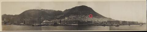
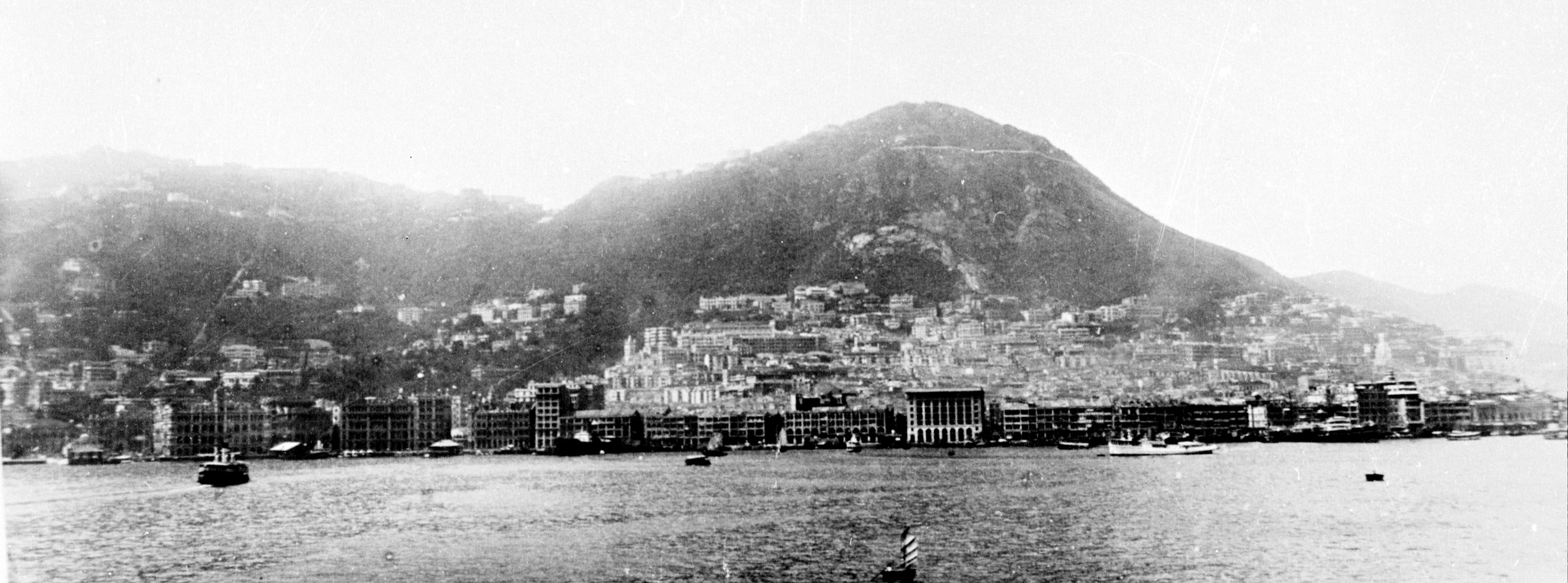
I think I have identified 29 Conduit Road on the amazingly high-resolution panorama of Hong Kong Island taken in 1906 and currently available for viewing here:
More information on this panorama can be found here: https://gwulo.com/media/47520
Please let me know what you think.
The significance of this find is more interesting than its face value. What it does is place the achievements of Ho Kom Tong (the owner of the house) into a socio-historical context, which today's high-rises and skyscrapers literally obscure.
At that time, the colony was a two-tier system with Europeans at the top of the tree and Chinese at the bottom. For example, when Ho Kom Tong was 22 years old, the 1888 Light and Pass Ordinance required Chinese residents to carry a lamp when passing at night because it assumed that all Chinese residents were potential criminals.
Old Hong Kong's top-down social hierarchy based on race, showed itself literally in where one lived, as one's status was defined by the elevation of one's home with Europeans at the top and Chinese at the bottom. The heel on the boot of the system was an ordinance forbidding Chinese from living on the Peak (repealed 1930) and the European District Reservation Ordinance of 1888 for urban areas in Hong Kong.
Within this context, the 1906 panoramic photograph shows that a house on Conduit Road (at the time) represented the height of social mobility and attainable uber status, because one can see the grand houses along its length literally sat on top of most of the Colony. Thus, it was no small feat for a Chinese person to live on Conduit Road and call oneself a neighbour of the likes of Sir Catchick Paul Chater (of Armenian descent). These individuals had reached the limits of what could be achieved by non-Europeans at that time in Hong Kong.
It would take the likes of Sir Robert Ho Tung (Ho Kom Tong's eldest brother) to break through the glass ceiling and gain acceptance into the Peak (literally as an exception to the rule).
The identification uses two different approaches:
A) Topographical identification.
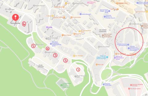
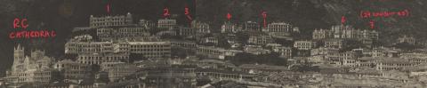
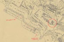
Image 1) Apple Maps was used to identify the location of 29 Conduit Road relative to the Roman Catholic cathedral, which is a prominent landmark on the 1906 panorama. In modern maps it is located at both the 7th building and 7th plot from the iconic Chater Hall (formerly Marble Hall) at 1 Conduit Road also in plot 1. Note: the distinctive bend in the road around plot/building 6, which almost forms a right-angle. This will be used to identify 29 Conduit Road in aerial photos.
Using a 1909 plan of the City of Victoria, Hong Kong available [here], it was possible to identify the same location for 29 Conduit Road (assuming plots and numbering haven't changed). This made possible a count of the number of plots from a key landmark: Marble Hall, and from the 1906 panorama to count the buildings to reach 29 Conduit Road.
Image 2) Below is a snippet from that street plan, which has been labeled to show two key reference points: the Roman Catholic cathedral and Marble Hall, 1 Conduit Road (which was famously owned by Sir Catchick Paul Chater). 29 Conduit Road should be the seventh property on Conduit Road when counted from Marble Hall. Again notice the identifying bend in the road at plot/building 6.
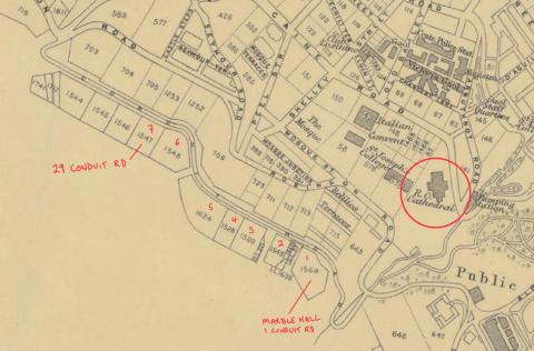
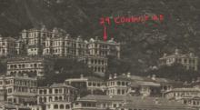
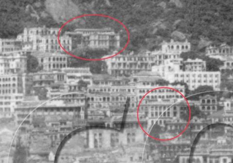
Image 3) Close crop of the panorama to show the buildings of interest:
There a couple of issues with this topological approach: empty plots and multiple buildings on one plot make counting difficult. Although there are properties on both sides of Conduit Road, in these old photos, the odd-numbered buildings sit above the even-numbered buildings which are situated below road level (as far as I can tell using both Google Street View and aerial photos).
[UPDATE: TN Kwok, in the comments below, has further identified 29 Conduit Road from a new perspective showing the rear of the property in a photo from Lugard Road looking over the Harbour to Kowloon.]
B) Features comparison
Image 4) A features-to-features comparison of the building identified in the panorama with known photos of 29 Conduit Road make a compelling case. Five features have been identified and are shown in a photo taken in the 1960s here:
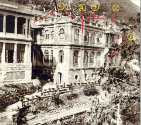
List of features:
- Noticeably larger column of windows (2nd from right).
- Masonic style triangle on top of (1).
- Three smaller windows grouped in the middle.
- The window on the far left is set in a faux square-corner turret.
- Three additional masonic style triangles.
Items 1, 3, and 4 make the front of the building asymmetrical, which makes it unique among buildings in the panorama and therefore more readily identifiable.
Image 5) The image below is of building 7 from the close crop of the panorama (above). When we compare it to our list we can see a one-to-one match of features, which makes it a strong match for 29 Conduit Road.
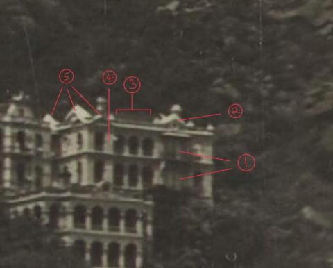
The 1906 image has various additional spherical globes on the roof which are not present in the 1960s photo, but it could be that the building was altered in the intervening time.
Image 6) The following painting of 29 Conduit Road shows the same five features:
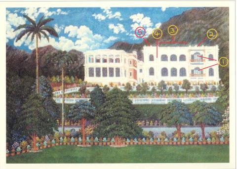
The painting shows a second house that Ho Kom Tong built to the left of the original building.
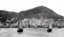
Image 7) In the crop (below) from the photo titled 'c.1935 view of Hong Kong from the harbour' (with two junks), we can see the 2nd and 3rd houses that Ho Kom Tong built at 29 Conduit Rd, which further supports this identification.
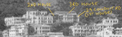
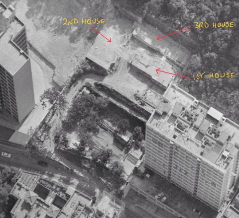
Image 8) The 1949 aerial photo below confirms that the plot identified contains the 3 buildings described above in image (7). It also shows the distinctive almost right-angled curve in the road mentioned in the maps in images (1) and (2).
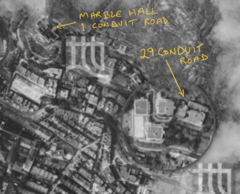
Image 9) The 1963 aerial photo below again shows the three houses (or at least their foundations) after they were demolished, and it shows the distinctive bend in the road which confirms its location relative to the maps in images (1) and (2).

Image 10) A different aerial photo of the same demolition site in image (9) makes it easier to recognise the buildings at 29 Conduit Road without any mental gymnastics, because it is in the same east-west orientation as all Peak-Harbour panoramas. In those, photos we see 29 Conduit Road face-on and that's the same here.
Conclusion: the two approaches (topology id. & features id.), when combined, provide compelling evidence that the correct property has been correctly identified in the panorama. Thoughts/comments welcome.
This analysis (if correct) can be used to identify the building in other photos, even if the resolution does not allow the recognition of features. Merely, the topological mapping could be sufficient. In this way, it can be spotted in the long list of photos.
Image 11) Once one knows how to spot 29 Conduit Road in old Peak-Harbour photos, one can use this to identify Kom Tong Hall in some some of them, for example:
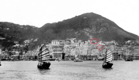
Image 12) The following close crop of image (11) shows Kom Tong Hall at roughly 4.30pm on a clock-face and around four buildings further down.
Here is a list of photos in which 29 Conduit Road can be identified using topology but not features. Those marked with an asterisk additionally show Kom Tong Hall.
https://gwulo.com/media/41178/zoom
1906 https://gwulo.com/media/45568/zoom
1909 https://gwulo.com/media/47586/zoom
1909 https://gwulo.com/media/47815/zoom
1909 https://gwulo.com/media/49931/zoom
1910 https://gwulo.com/media/51982/zoom
1917 https://hpcbristol.net/visual/WC02-60
1920s https://gwulo.com/media/32842/zoom
*1924 https://digitalrepository.lib.hku.hk/catalog/f7628m58b#
1924 https://www.grs.gov.hk/ws/erp/Scenes-of-HK/en/home/index.html
1924 https://gwulo.com/media/12863/zoom
*1927 https://gwulo.com/media/30697/zoom
1930 https://www.grs.gov.hk/ws/hip/common/img/record/019.jpg
*1935 Two junks https://gwulo.com/media/19421/zoom
1935 https://gwulo.com/media/19421/zoom
1937 https://hpcbristol.net/visual/Hn-d046
*1937/09/17 https://gwulo.com/media/45394/zoom
*1937/09/17 https://gwulo.com/media/31437/zoom
1930-50 warship https://digitalrepository.lib.hku.hk/catalog/j9607q787#
*1950s Star Ferry https://digitalrepository.lib.hku.hk/catalog/2j62zc08c#
*1961-62 Star Ferry https://digitalrepository.lib.hku.hk/catalog/s752cm83f#
[Update: as spotted by TN Kwok, in the comments below, the last two links are of the same photo].
Photos that show this Place
Comments
a photo of the building in the 60's
Interesting and full of details.
The last two links in the text above are almost the same photo, both taken in the late-1950's, namely:
" *1950s Star Ferry https://digitalrepository.lib.hku.hk/catalog/2j62zc08c# "
" *1961-62 Star Ferry https://digitalrepository.lib.hku.hk/catalog/s752cm83f# "
Seems the house(s) was still inhabited in the early-1960's before demolition.
Below is a photo taken from Lugard Road, between April and August 1961, showing sign that it was probably still occupied around 1961 on the roof of (one of) the building at that site.