The company was active in Hong Kong after the First World War. On the website Historical Photos of China (University of Bristol) the George Trobridge Collection can be found. Frederic George Trobridge was a mining engineer and the managing director of the China Mining and Metal Company Ltd., Hong Kong. He arrived in Hong Kong in 1919 and left in 1925. He worked also at several locations in Mainland China, mostly Guangdong.
George Trobridge took a lot of photos in Hong Kong and southern China, mainly Guangdong and Hunan. Most photos show factories and equipment of the company which was active in dressing, smelting and refining of non-ferrous metals. The company in Hong Kong owned a launch named “Stibnite”. This is the Latin name for a mineral containing Antimony. Antimony was used in alloys e.g. for type metal or tin ware. In the 1910s, new processes were developed which allowed to produce theses non-ferrous metals in large quantities at reasonable costs. Likely the company not only produced Antimony but also other metals. The origin of the ore is unknown to me, it came either from a mine in Hong Kong or from Guandong.
George Trobridge labelled all his photos, some are labelled “Hongkong works”. The location is not given, but this was likely in the New Territories.
China Mining and Metal Company Ltd. were incorporated on the 14 April, 1916. The company is also listed amongst others permitted to work according to the Non-Ferrous Metal Industry Ordinance from 1919. Additionally, the company is listed in the Juror’s lists from 1917 to 1926. In the lists from 1923 and 1924, 9 people from this company can be found in each year - obviously the most prosperous time. Interesting to note is the fact that the mangers lived on Hong Kong Island, only the foreman and the chemist (!) lived at “Company’s Works”. George Trobridge stayed at the Peak Hotel, the way to the works was quite long; Peak Tram, rickshaw (likely), Star Ferry, then probably KCR train and rickshaw again. This would indicate that the works were somewhere near a train station.
The Hong Kong Government Gazette from 8 November 1928 refers the dissolving of the company.
One of his photos show the Hong Kong Works in 1922.
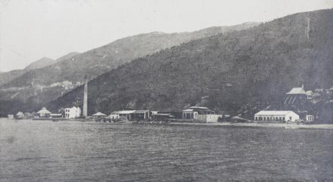
Different views are here and here. Others can be found in the collection.
Obviously a remote area. This was necessary because there were no filters and retaining systems in the process, all exhaust gases and dust were emitted into the air – they were quite toxic.
So the question arises: where was the location of the company?
Question answered by Phil, see the created place Hong Kong Works of the China Mining and Metal Company Ltd. [c.1920-1928]
Comments
Tsing Yi
Hi Klaus, the ridgeline in the first link you provide is a view o
f Tai Mo Shan seen from the sw, so I think* the mine was most likely along the north shore of Tsing Yi. The location would be where all the boatyards are now along Tam Kon Shan Road, or perhaps slightly further east nr Mun Tsai Tong area.Phil
*just a guess, I haven't examined it in detail yet.
Errata: actually, the angle on Tai Mo Shan is much more indicative of the old coastline along Kwai Chung area. If you lookon the 1924 aerial imagery(https://www.hkmaps.hk/viewer.html), there looks to be something along where the modern Lai Cho Road/Lai King Hill Rd now runs that may match the mining facilities.
Re: Tsing Yi
Phil, this is a possible location. The 1924 map on https://www.hkmaps.hk/viewer.html shows further south the name Lap Sap Wan with 6 buildings, this is probably a small village and not the factory. On one of the photos in the collection is the company's steam launch near Lantau Island, this should indicate the location of the works on the western shores of Kowloon/NT's.
Gin Drinkers Bay, Kwai Chung
Hi Klaus, I've had time to examine further and I am confident the works was located in the Kwai Chung area. On the 1924 map and aerial imagery there is some reasonably straight coastline in Gin Drinker's Bay around the area marked as "Mong Shü". The aerial imagery also shows a cluster of buildings, and piers, here. This lines up exactly with the angle on Tai Mo Shan that can be seen in the first linked image. The second image shows the view from the same area over to the north of Tsing Yi island, between Tsing Chau Teng (then, still an island) and the nw tip of the bay (this "tip" is Ma Kok Shan and was later turned into the cemetery). Obviously this gap, as well as the whole bay, has since been reclaimed and is now Kwai Chung Park.
Phil
Re: Gin Drinkers Bay
Think you found the exact location. Besides the two piers, the map and the aerial photograph show a valley a bit further north which can be seen on the left side of the photo. A nullah is running though it, this was likely used for the reservoir.
P.S. When browsed the collection once again, I found a photo labelled TAI MO SHAN FROM GIN DRINKER'S BAY. This seems to be the final clue, and thank you again, Phil, for identifying the location without this information.
Gin Drinkers Bay
Great stuff, glad to be of help.