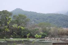
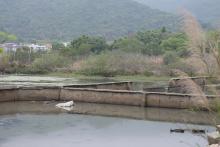
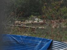
I went to have another look earlier today. Definitely NOT paddy fields. Pond is possible, but why partitioned with concrete? If they had been fish ponds, they looked very different than those in the New Territories. Unable to tell how deep they are though. Some partitioned area further away are full of reed, but those immediately next to Ngan Ho Court are empty. From closer observation some of the existing partitions are doubled, with water channel in between. Photos later.
If your schedule allows suggest to go there to have a look before or after your People talk at Vibe. It is not that far away.
T
ps I have seen similar partitioning structures in Tai O, right next to Siu Kei Yuen.
Comments
Looking through the maps at…
Looking through the maps at https://www.hkmaps.hk/viewer.html, these are a relatively recent structure:
Is it possible these walls surrounded fish ponds, rather than salt pans?
Re: Salt Pans or something else
Hi David,
I went to have another look earlier today. Definitely NOT paddy fields. Pond is possible, but why partitioned with concrete? If they had been fish ponds, they looked very different than those in the New Territories. Unable to tell how deep they are though. Some partitioned area further away are full of reed, but those immediately next to Ngan Ho Court are empty. From closer observation some of the existing partitions are doubled, with water channel in between. Photos later.
If your schedule allows suggest to go there to have a look before or after your People talk at Vibe. It is not that far away.
T
ps I have seen similar partitioning structures in Tai O, right next to Siu Kei Yuen.