Location of marker is approximate.
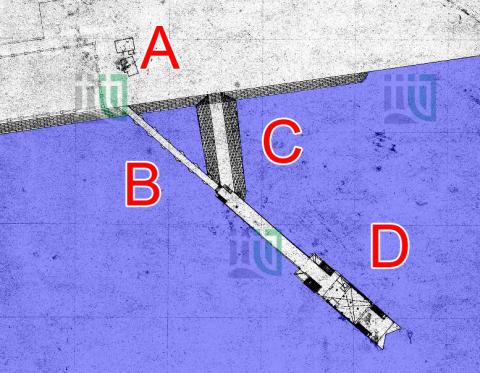
This causeway was a small addition to the Lung Tsun / Kowloon City Pier. I've marked the causeway with a 'C' on this 1930s map of the area:
- A: The sea wall and reclaimed land
- B: The southern end of the granite section of the Lung Tsun Stone Bridge. (The points of the hexagonal pillars can be seen.)
- C: This causeway
- D: The concrete pier, 'Kowloon City Pier'
Construction in 1934
In March 1934, the government requested tenders to build the causeway in the Government Gazette:
|
Public Works Department. No. S. 97.—It is hereby notified that sealed tenders in triplicate, which should be clearly marked "Tender for Raising Level of Causeway to Kowloon City Pier", will be received at the Colonial Secretary’s Office until Noon of Tuesday, the 20th day of March, 1934. The contract comprises the dumping of pell-mell rubble to form a causeway to Kowloon City Pier and the surfacing of same with cement concrete and any other contingent works. For form of tender, specification and further particulars apply at this Office. The Government does not bind itself to accept the lowest or any tender. R. M. Henderson, 7th March, 1934. |
The work was finished that year, as noted in the Public Works Department's (PWD) Annual Report for 1934:
|
PORT WORKS 184. Raising Level of Causeway to Kowloon City Pier: — A contract for this work was let to Messrs. Lam Woo & Co. for $2,440.00. Progress was slow but all construction was completed on the 5th December. Expenditure $1,236.34 |
Buried circa 1942
When Kai Tak was expanded during the Japanese occupation of Hong Kong, the causeway was buried under the reclamation and disappeared from sight. I've guessed 1942 as the likely date but it could have been buried later in 1943.
Excavation in 2008-9
An archeological excavation of the site took place from 31 October 2008 to 20 February 2009. The Further Archeological Excavation Report records the discovery of one side of the causeway:
| 5.3.3 A single side sloping-faced portion of the 1930s’ causeway of overall 20.4m length and approximately 4m width was discovered. The top elevation of this causeway was at 3.32 mPD. The causeway clearly reflected the design of a granite rubble core/foundation faced with rough-dressed granite blocks which were mostly sub-square. The full cross-section of the causeway was not exposed. |
Was the causeway built in 1933 or 1934?
The government records from 1934 quoted above note the causeway was built in 1934.
However the modern government records about this site refer to it as the '1933 Causeway', eg point 4.4.8 in the Further Archeological Excavation Report mentioned above notes: "... A causeway in form of seawall was constructed for the Former Kowloon City Pier in 1933 ... ". The various documents quote the source as 何佩然 2004 (地換山移 : 香港海港及土地發展一百六十年).
I got a copy of the English-language version (Challenges for an Evolving City, 160 Years of Port and Land Development in Hong Kong by Ho Pui-yin) from the library. The causeway is mentioned in an entry in Table 2.12, Pier Erection and Reconstruction Expenditure (1885-1939):
- Year: 1933
- Work Item: Raising level of causeway to Kowloon City pier
- Expenditure: HK$1,236
Since the descriptions of the work item and amount spent match the entry from the 1934 PWD Annual Report, I believe the book has a mistake, and the correct year should be 1934.


Comments
Aerial Photograph
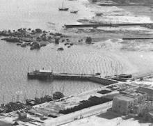
The causeway is visible on an aerial photograph from 1934 on hkmaps.hk.